TopoQuest Logo
Do you find TopoQuest useful?
Help keep TopoQuest running and adding new maps/features by donating!
Bitcoin:  19c7KJd3qBynnjoSw5npx9KScwjBe4ifkT
Litecoin:  LXs6TkuXGGXo1vDsWCkWVdjQX94eUKd6ui
Home View Maps Find Maps Find Places Resources & Links


Ashton, Florida Topographic Map

USGS Map Title: Ashton, FL
USGS Map MRC: 28081B2
DRG (GeoTIFF) Download: o28081b2.tif


Neighboring USGS Topographic Map Quads:


  Saint Cloud North, FL  
28081C3
 

  Narcoossee, FL  
28081C2
 

  Narcoossee SE, FL  
28081C1
 

  Saint Cloud South, FL  
28081B3
 

  Ashton, FL  
28081B2
 

  Holopaw, FL  
28081B1
 

  Cypress Lake, FL  
28081A3
 

  Holopaw SW, FL  
28081A2
 

  Holopaw SE, FL  
28081A1


Map MRC Location:

N29°
W82°
N29°
W81°
H8 H7 H6 H5 H4 H3 H2 H1
G8 G7 G6 G5 G4 G3 G2 G1
F8 F7 F6 F5 F4 F3 F2 F1
E8 E7 E6 E5 E4 E3 E2 E1
D8 D7 D6 D5 D4 D3 D2 D1
C8 C7 C6 C5 C4 C3 C2 C1
B8 B7 B6 B5 B4 B3 B2 B1
A8 A7 A6 A5 A4 A3 A2 A1
N28°
W82°
N28°
W81°

Ashton, FL USGS 1:24K Topographic Map Preview:
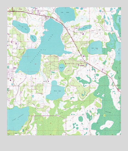
Ashton, FL USGS Topographic Map
Click on map above to begin viewing in our Map Viewer.

This topographic map contains these locations and features:
Feature Name Type Latitude Longitude GNIS ID View Map
Alligator LakeSwampN28.2101°W81.2100°277794View Map
AshtonPopulated PlaceN28.2464°W81.2440°294659View Map
Bay LakeLakeN28.2302°W81.1636°278208View Map
Berl IslandIslandN28.1350°W81.2265°278504View Map
Big Bend SwampSwampN28.1282°W81.1404°278629View Map
Brick LakeLakeN28.1680°W81.1962°279374View Map
Buck LakeLakeN28.2106°W81.1529°279574View Map
Canoe CreekStreamN28.1278°W81.2362°279991View Map
Cat LakeLakeN28.2069°W81.1260°280133View Map
Colonial Mobile Home ParkPopulated PlaceN28.2454°W81.2145°2452208View Map
Gator AirparkAirportN28.1576°W81.2375°2676677View Map
HarmonyPopulated PlaceN28.1895°W81.1451°2063058View Map
Harmony High SchoolSchoolN28.1942°W81.1576°2063059View Map
Lake GentryLakeN28.1409°W81.2439°283023View Map
Lake LizzieLakeN28.2452°W81.1857°285895View Map
Lakeview Trailer TerracePopulated PlaceN28.2377°W81.1964°2452218View Map
Live Oak LakeLakeN28.2311°W81.2343°285874View Map
Osceola County Fire Rescue and Emergency Medical Services Department Station 53BuildingN28.1802°W81.2437°2331381View Map
Pearl LakeLakeN28.1915°W81.1901°288634View Map
Sardine LakeLakeN28.2200°W81.2211°290689View Map
Scrub IslandIslandN28.1767°W81.1865°290773View Map
Sharps Mobile Home ParkPopulated PlaceN28.2462°W81.2134°2452212View Map
Sweet Bay IslandIslandN28.1522°W81.1792°291931View Map

Note: Coordinates in the location and feature list above are referenced to NAD83 datum.


Copyright (C) 2008-2025 Ryan Niemi / Sunset Dynamics ... All Rights Reserved