TopoQuest Logo
Do you find TopoQuest useful?
Help keep TopoQuest running and adding new maps/features by donating!
Bitcoin:  19c7KJd3qBynnjoSw5npx9KScwjBe4ifkT
Litecoin:  LXs6TkuXGGXo1vDsWCkWVdjQX94eUKd6ui
Home View Maps Find Maps Find Places Resources & Links


Narcoossee, Florida Topographic Map

USGS Map Title: Narcoossee, FL
USGS Map MRC: 28081C2
DRG (GeoTIFF) Download: o28081c2.tif


Neighboring USGS Topographic Map Quads:


  Pine Castle, FL  
28081D3
 

  Narcoossee NW, FL  
28081D2
 

  Narcoossee NE, FL  
28081D1
 

  Saint Cloud North, FL  
28081C3
 

  Narcoossee, FL  
28081C2
 

  Narcoossee SE, FL  
28081C1
 

  Saint Cloud South, FL  
28081B3
 

  Ashton, FL  
28081B2
 

  Holopaw, FL  
28081B1


Map MRC Location:

N29°
W82°
N29°
W81°
H8 H7 H6 H5 H4 H3 H2 H1
G8 G7 G6 G5 G4 G3 G2 G1
F8 F7 F6 F5 F4 F3 F2 F1
E8 E7 E6 E5 E4 E3 E2 E1
D8 D7 D6 D5 D4 D3 D2 D1
C8 C7 C6 C5 C4 C3 C2 C1
B8 B7 B6 B5 B4 B3 B2 B1
A8 A7 A6 A5 A4 A3 A2 A1
N28°
W82°
N28°
W81°

Narcoossee, FL USGS 1:24K Topographic Map Preview:
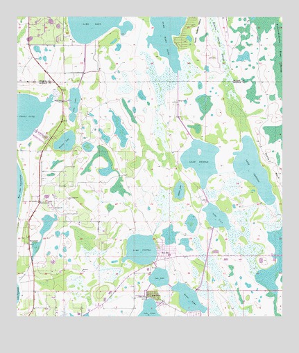
Narcoossee, FL USGS Topographic Map
Click on map above to begin viewing in our Map Viewer.

This topographic map contains these locations and features:
Feature Name Type Latitude Longitude GNIS ID View Map
Ajay LakeLakeN28.3405°W81.2228°277708View Map
Bullock LakeLakeN28.3029°W81.1732°279657View Map
Coon LakeLakeN28.2665°W81.1829°280767View Map
Fells CoveBayN28.3343°W81.2471°282413View Map
Hinden LakeLakeN28.3231°W81.2269°284046View Map
Lake CenterLakeN28.2782°W81.1914°280245View Map
Lake JoelLakeN28.2919°W81.1558°284827View Map
Lake Mary JaneLakeN28.3731°W81.1793°286482View Map
Lake MyrtleLakeN28.3156°W81.1635°287513View Map
Lake PrestonLakeN28.3116°W81.1384°289298View Map
NarcoosseePopulated PlaceN28.2983°W81.2390°287534View Map
Narcoossee Arthur Fell CemeteryCemeteryN28.3000°W81.2259°287535View Map
Narcoossee Baptist ChurchChurchN28.2989°W81.2401°299510View Map
New EdenPopulated PlaceN28.2781°W81.1795°287612View Map
North Roberts IslandIslandN28.3675°W81.1642°287861View Map
Osceola County Fire Rescue and Emergency Medical Services Department Station 51BuildingN28.2988°W81.2384°2331131View Map
Osceola County Fire Rescue and Emergency Medical Services Department Station 52BuildingN28.2667°W81.1950°2331380View Map
Pine GrovePopulated PlaceN28.2597°W81.1845°288837View Map
RunnymedePopulated PlaceN28.2814°W81.2440°294914View Map
Saint Luke ChurchChurchN28.2958°W81.2326°290269View Map
Sandalwood Mobile Home ParkPopulated PlaceN28.3475°W81.2392°2452221View Map
Trout LakeLakeN28.2582°W81.1694°292474View Map
WNZQ-AM (Saint Cloud)TowerN28.2808°W81.2434°310135View Map

Note: Coordinates in the location and feature list above are referenced to NAD83 datum.


Copyright (C) 2008-2025 Ryan Niemi / Sunset Dynamics ... All Rights Reserved