TopoQuest Logo
Do you find TopoQuest useful?
Help keep TopoQuest running and adding new maps/features by donating!
Bitcoin:  19c7KJd3qBynnjoSw5npx9KScwjBe4ifkT
Litecoin:  LXs6TkuXGGXo1vDsWCkWVdjQX94eUKd6ui
Home View Maps Find Maps Find Places Resources & Links


Genoa, Nevada Topographic Map

USGS Map Title: Genoa, NV
USGS Map MRC: 39119A7
DRG (GeoTIFF) Download: o39119a7.tif


Neighboring USGS Topographic Map Quads:


  Marlette Lake, NV  
39119B8
 

  Carson City, NV  
39119B7
 

  New Empire, NV  
39119B6
 

  Glenbrook, NV  
39119A8
 

  Genoa, NV  
39119A7
 

  McTarnahan Hill, NV  
39119A6
 

  South Lake Tahoe, CA  
38119H8
 

  Minden, NV  
38119H7
 

  Gardnerville, NV  
38119H6


Map MRC Location:

N40°
W120°
N40°
W119°
H8 H7 H6 H5 H4 H3 H2 H1
G8 G7 G6 G5 G4 G3 G2 G1
F8 F7 F6 F5 F4 F3 F2 F1
E8 E7 E6 E5 E4 E3 E2 E1
D8 D7 D6 D5 D4 D3 D2 D1
C8 C7 C6 C5 C4 C3 C2 C1
B8 B7 B6 B5 B4 B3 B2 B1
A8 A7 A6 A5 A4 A3 A2 A1
N39°
W120°
N39°
W119°

Genoa, NV USGS 1:24K Topographic Map Preview:
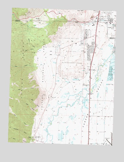
Genoa, NV USGS Topographic Map
Click on map above to begin viewing in our Map Viewer.

This topographic map contains these locations and features:
Feature Name Type Latitude Longitude GNIS ID View Map
Adams CanyonValleyN39.0280°W119.8430°858673View Map
Adams RanchLocaleN39.0249°W119.8346°847679View Map
Ambrosetti PondLakeN39.0406°W119.7868°858698View Map
Barrett Mill (historical)LocaleN39.1113°W119.7921°847683View Map
Bennett CanyonValleyN39.0880°W119.8421°858869View Map
Bridge HousePopulated PlaceN39.0432°W119.7813°855591View Map
Capital Christian SchoolSchoolN39.1169°W119.7547°2087938View Map
Chedic CanyonValleyN39.0855°W119.8455°859212View Map
Childs CanyonValleyN39.0324°W119.8338°859227View Map
Clear Creek CanyonValleyN39.1119°W119.7935°847694View Map
Clear Creek Station (historical)LocaleN39.1157°W119.7713°847693View Map
Clear Creek Youth CenterBuildingN39.1152°W119.8463°859260View Map
Cook RanchLocaleN39.0419°W119.8249°847680View Map
Cradlebaugh (historical)Populated PlaceN39.0432°W119.7810°857706View Map
Cradlebaugh BridgeBridgeN39.0480°W119.7799°859414View Map
Cradlebaugh Post Office (historical)Post OfficeN39.0432°W119.7810°864728View Map
Douglas County Sheriff SubstationBuildingN39.0966°W119.7665°2740008View Map
East Fork Fire and Paramedic Districts Station 12BuildingN39.1003°W119.7711°2581378View Map
East Fork Fire and Paramedic Districts Station 15 Jacks Valley SeasonalBuildingN39.0883°W119.8165°2581383View Map
East Fork Fire and Paramedic Districts Station 16BuildingN39.0887°W119.7792°2581393View Map
East Fork Fire and Paramedic Districts Station 3 Genoa Volunteer Fire DepartmentBuildingN39.0048°W119.8463°2581220View Map
Fuji ParkParkN39.1155°W119.7771°859774View Map
GenoaPopulated PlaceN39.0044°W119.8471°859807View Map
Genoa CanyonValleyN39.0005°W119.8468°859808View Map
Genoa CemeteryCemeteryN39.0116°W119.8441°859809View Map
Genoa Census Designated PlaceCensusN39.0256°W119.8309°2583925View Map
Genoa Mining DistrictCivilN39.0055°W119.8585°848421View Map
Genoa Station (historical)LocaleN39.0044°W119.8471°848225View Map
Grace Christian AcademySchoolN39.0076°W119.7631°2089665View Map
Haskells Mill (historical)LocaleN39.1124°W119.8299°856550View Map
Heyburn DitchCanalN39.0319°W119.7613°859976View Map
Hobo Hot SpringsSpringN39.0591°W119.8163°860005View Map
Hollister RanchLocaleN39.0185°W119.8377°847707View Map
Indian HillsRangeN39.0721°W119.8046°1699882View Map
Indian HillsPopulated PlaceN39.0860°W119.7841°1867347View Map
Indian Hills Census Designated PlaceCensusN39.0894°W119.7977°2408421View Map
Jacks ValleyBasinN39.0838°W119.8288°860172View Map
Jacks Valley CemeteryCemeteryN39.0841°W119.8468°860173View Map
Jacks Valley Elementary SchoolSchoolN39.0936°W119.7983°855702View Map
Jacks Valley RanchLocaleN39.0799°W119.8435°847710View Map
Jacks Valley Wildlife Management AreaParkN39.0877°W119.8035°862663View Map
James CanyonValleyN39.0485°W119.8299°860184View Map
James Canyon RanchLocaleN39.0324°W119.8305°847708View Map
Liberty Christian AcademySchoolN39.0994°W119.7752°857011View Map
Minden WarehouseLocaleN39.0013°W119.7582°864988View Map
Minden-Tahoe AirportAirportN39.0007°W119.7554°864091View Map
Mormon Station Historic State MonumentParkN39.0044°W119.8452°860646View Map
Old Mormon Station (historical)LocaleN39.0160°W119.8382°848162View Map
Ormsby County FarmLocaleN39.1141°W119.7793°860848View Map
Parker Airport (historical)AirportN39.1235°W119.7532°855604View Map
Rite of PassageSchoolN39.0250°W119.7523°2089667View Map
Schoolhouse CanyonValleyN39.0063°W119.8480°861286View Map
Sierra CanyonValleyN39.0177°W119.8416°861377View Map
Sierra Front Interagency Dispatch and Air Operations CenterBuildingN39.0092°W119.7555°2581380View Map
Snyder Meadows State ParkParkN39.1152°W119.8438°846181View Map
Snyder RanchLocaleN39.0894°W119.8341°847709View Map
StewartPopulated PlaceN39.1163°W119.7585°861589View Map
Stewart Branch Post Office (historical)Post OfficeN39.1163°W119.7585°864820View Map
Stewart CommunityCivilN39.0337°W119.7989°2419480View Map
Stewart Indian School (historical)SchoolN39.1132°W119.7574°861592View Map
Stewart Indian School RanchLocaleN39.0644°W119.8218°848467View Map
Sulphur SpringsSpringN39.0849°W119.7674°847684View Map
Tahoe-Carson SpeedwayParkN39.1085°W119.7555°861665View Map
Thornton (historical)LocaleN39.1135°W119.7807°858596View Map
Tiedge RanchLocaleN39.0057°W119.8177°863193View Map
Voltaire CanyonValleyN39.1249°W119.7910°861860View Map
Water CanyonValleyN39.0713°W119.8482°861918View Map
Webster Hotel StationLocaleN39.0663°W119.7849°857332View Map
Williams SloughStreamN39.0441°W119.7846°862026View Map
Winkleman RanchLocaleN39.0124°W119.8246°847678View Map

Note: Coordinates in the location and feature list above are referenced to NAD83 datum.


Copyright (C) 2008-2024 Ryan Niemi / Sunset Dynamics ... All Rights Reserved