TopoQuest Logo
Do you find TopoQuest useful?
Help keep TopoQuest running and adding new maps/features by donating!
Bitcoin:  19c7KJd3qBynnjoSw5npx9KScwjBe4ifkT
Litecoin:  LXs6TkuXGGXo1vDsWCkWVdjQX94eUKd6ui
Home View Maps Find Maps Find Places Resources & Links


Gladesville, West Virginia Topographic Map

USGS Map Title: Gladesville, WV
USGS Map MRC: 39079D8
DRG (GeoTIFF) Download: o39079d8.tif


Neighboring USGS Topographic Map Quads:


  Rivesville, WV  
39080E1
 

  Morgantown South, WV  
39079E8
 

  Masontown, WV  
39079E7
 

  Fairmont East, WV  
39080D1
 

  Gladesville, WV  
39079D8
 

  Newburg, WV  
39079D7
 

  Grafton, WV  
39080C1
 

  Thornton, WV  
39079C8
 

  Fellowsville, WV  
39079C7


Map MRC Location:

N40°
W80°
N40°
W79°
H8 H7 H6 H5 H4 H3 H2 H1
G8 G7 G6 G5 G4 G3 G2 G1
F8 F7 F6 F5 F4 F3 F2 F1
E8 E7 E6 E5 E4 E3 E2 E1
D8 D7 D6 D5 D4 D3 D2 D1
C8 C7 C6 C5 C4 C3 C2 C1
B8 B7 B6 B5 B4 B3 B2 B1
A8 A7 A6 A5 A4 A3 A2 A1
N39°
W80°
N39°
W79°

Gladesville, WV USGS 1:24K Topographic Map Preview:
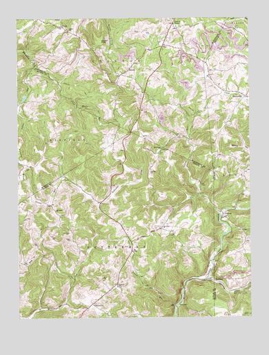
Gladesville, WV USGS Topographic Map
Click on map above to begin viewing in our Map Viewer.

This topographic map contains these locations and features:
Feature Name Type Latitude Longitude GNIS ID View Map
Amnon CemeteryCemeteryN39.4009°W79.9876°1534924View Map
Amnon Primitive Baptist Church (historical)ChurchN39.4006°W79.9876°1689759View Map
Bethel Baptist ChurchChurchN39.4962°W79.9756°1535713View Map
Bethel School (historical)SchoolN39.4954°W79.9720°1535722View Map
Boyce CemeteryCemeteryN39.3920°W79.9551°1536272View Map
Brown CemeteryCemeteryN39.4945°W79.9337°1536407View Map
Browns ChapelPopulated PlaceN39.4979°W79.9153°1536432View Map
Browns Chapel Elementary SchoolSchoolN39.4965°W79.9142°1728425View Map
Browns Chapel Methodist ChurchChurchN39.4959°W79.9137°1728426View Map
Browns-Halleck LibraryBuildingN39.4965°W79.9142°1728427View Map
Cherry RunStreamN39.4334°W79.9765°1537249View Map
Dean Schoolhouse (historical)SchoolN39.4045°W79.9831°1689777View Map
Fairview School (historical)SchoolN39.4365°W79.8787°1560100View Map
Faith Christian FellowshipChurchN39.4894°W79.9190°2586399View Map
Ford CemeteryCemeteryN39.4101°W79.9178°1539117View Map
GladesvillePopulated PlaceN39.4670°W79.8770°1554561View Map
HalleckPopulated PlaceN39.4793°W79.9392°1554626View Map
HardmanPopulated PlaceN39.3904°W79.8948°1554645View Map
Haymond School (historical)SchoolN39.3881°W79.9473°1540090View Map
Haymond United Methodist ChurchChurchN39.3804°W79.9598°1540087View Map
Hope Halleck United Methodist ChurchChurchN39.4779°W79.9412°1728452View Map
Hope Halleck United Methodist Church CemeteryCemeteryN39.4778°W79.9414°2586250View Map
IrontownPopulated PlaceN39.3793°W79.9151°1554781View Map
Kincaid KnobSummitN39.4904°W79.9548°1554878View Map
Kincaid School (historical)SchoolN39.4906°W79.9765°1728458View Map
Laurel RunStreamN39.4187°W79.8915°1541521View Map
Laurel RunStreamN39.4793°W79.9909°1541523View Map
Laurel Run Lake DamDamN39.4668°W79.9965°1559025View Map
Laurel Run School (historical)SchoolN39.4212°W79.9173°1689810View Map
Little Laurel RunStreamN39.3804°W79.9165°1542154View Map
Manacea SpringSpringN39.4173°W79.8903°1558596View Map
Maple RunStreamN39.4634°W79.9673°1542736View Map
Martin School (historical)SchoolN39.4623°W79.9109°1728467View Map
Matthew CemeteryCemeteryN39.4356°W79.9290°1542870View Map
McConkey CemeteryCemeteryN39.4104°W79.9728°1542956View Map
McConkey ChurchChurchN39.4195°W79.9798°1542957View Map
McConkey School (historical)SchoolN39.4129°W79.9776°1689814View Map
Moran CemeteryCemeteryN39.4081°W79.9823°1543525View Map
Moran School (historical)SchoolN39.4537°W79.9806°1718181View Map
Oak Grove CemeteryCemeteryN39.4145°W79.9237°1689822View Map
Oak Grove ChurchChurchN39.4129°W79.9226°1544291View Map
Oak Grove School (historical)SchoolN39.4129°W79.9228°1689823View Map
Oakdale School (historical)SchoolN39.4587°W79.9387°1728477View Map
Paradise Lake Golf CourseLocaleN39.4975°W79.9060°2634147View Map
Pride CemeteryCemeteryN39.4373°W79.9959°1545269View Map
Raccoon CreekStreamN39.3912°W79.8978°1545361View Map
Roderick School (historical)SchoolN39.4109°W79.9265°1689838View Map
Rogers CemeteryCemeteryN39.4073°W79.9720°1546043View Map
South Point ChurchChurchN39.4456°W79.9226°1547089View Map
TriunePopulated PlaceN39.4965°W79.9751°1555826View Map
Triune - Halleck Volunteer Fire DepartmentBuildingN39.4972°W79.9769°2577720View Map
VictoriaPopulated PlaceN39.4179°W79.8892°1548657View Map
Wickwire School (historical)SchoolN39.3793°W79.9884°1689873View Map

Note: Coordinates in the location and feature list above are referenced to NAD83 datum.


Copyright (C) 2008-2024 Ryan Niemi / Sunset Dynamics ... All Rights Reserved