TopoQuest Logo
Do you find TopoQuest useful?
Help keep TopoQuest running and adding new maps/features by donating!
Bitcoin:  19c7KJd3qBynnjoSw5npx9KScwjBe4ifkT
Litecoin:  LXs6TkuXGGXo1vDsWCkWVdjQX94eUKd6ui
Home View Maps Find Maps Find Places Resources & Links


Glenwood, West Virginia Topographic Map

USGS Map Title: Glenwood, WV
USGS Map MRC: 38082E2
DRG (GeoTIFF) Download: o38082e2.tif


Neighboring USGS Topographic Map Quads:


  Mercerville, OH  
38082F3
 

  Apple Grove, WV  
38082F2
 

  Arlee, WV  
38082F1
 

  Athalia, OH  
38082E3
 

  Glenwood, WV  
38082E2
 

  Mount Olive, WV  
38082E1
 

  Barboursville, WV  
38082D3
 

  Milton, WV  
38082D2
 

  Hurricane, WV  
38082D1


Map MRC Location:

N39°
W83°
N39°
W82°
H8 H7 H6 H5 H4 H3 H2 H1
G8 G7 G6 G5 G4 G3 G2 G1
F8 F7 F6 F5 F4 F3 F2 F1
E8 E7 E6 E5 E4 E3 E2 E1
D8 D7 D6 D5 D4 D3 D2 D1
C8 C7 C6 C5 C4 C3 C2 C1
B8 B7 B6 B5 B4 B3 B2 B1
A8 A7 A6 A5 A4 A3 A2 A1
N38°
W83°
N38°
W82°

Glenwood, WV USGS 1:24K Topographic Map Preview:
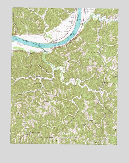
Glenwood, WV USGS Topographic Map
Click on map above to begin viewing in our Map Viewer.

This topographic map contains these locations and features:
Feature Name Type Latitude Longitude GNIS ID View Map
AshtonPopulated PlaceN38.6243°W82.1646°1550121View Map
Barker RidgeRidgeN38.5068°W82.1954°1535233View Map
Barker Ridge CemeteryCemeteryN38.5092°W82.1908°2724829View Map
Barker Ridge ChurchChurchN38.5048°W82.2040°1535235View Map
Barker School (historical)SchoolN38.5045°W82.1907°1535238View Map
Bear Hollow CreekStreamN38.5462°W82.1365°1535375View Map
Beech Grove School (historical)SchoolN38.5573°W82.1410°1535540View Map
Bexfield CemeteryCemeteryN38.5080°W82.2019°2724832View Map
Big 4 ChurchChurchN38.6040°W82.2168°1075373View Map
Big Four CemeteryCemeteryN38.6045°W82.2168°1964039View Map
Big Four HillSummitN38.6068°W82.2185°1068746View Map
Bryan CreekStreamN38.5518°W82.1665°1536527View Map
Central School (historical)SchoolN38.5137°W82.2332°1537170View Map
Chestnut Grove CemeteryCemeteryN38.5052°W82.1377°2726305View Map
Chestnut Grove ChurchChurchN38.5051°W82.1379°1537276View Map
CloverPopulated PlaceN38.5834°W82.2276°1549633View Map
Clover Railroad OverpassBridgeN38.5861°W82.2395°2635349View Map
Cottonwood BarBarN38.5973°W82.2454°1067111View Map
Dudley GapPopulated PlaceN38.5029°W82.1443°1538406View Map
Eighteenmile CreekStreamN38.6101°W82.1696°1538579View Map
Fairfield ChurchChurchN38.5643°W82.1257°1538789View Map
GlenwoodPopulated PlaceN38.5918°W82.1865°1539470View Map
Glenwood Post OfficePost OfficeN38.5912°W82.1889°1560198View Map
Green Bottom Wildlife Management AreaParkN38.5904°W82.2488°2043526View Map
Guyan CreekStreamN38.5884°W82.2157°1539804View Map
GwinnPopulated PlaceN38.5609°W82.2143°1549722View Map
Hannon LandingLocaleN38.5923°W82.2071°1051230View Map
HomesteadLocaleN38.5848°W82.2457°1540414View Map
Horse CreekStreamN38.6195°W82.1726°1051232View Map
Jenkins BranchStreamN38.5154°W82.1435°1540857View Map
Jenkins Plantation MuseumBuildingN38.5867°W82.2491°2727794View Map
Knife BranchStreamN38.5512°W82.1435°1541266View Map
Lacey Lane Post LightBuildingN38.6000°W82.2167°2702471View Map
Lawrence ChapelChurchN38.5176°W82.1651°1541560View Map
Left Fork Sprulock CreekStreamN38.5595°W82.2146°1541731View Map
Little Swan CreekStreamN38.6162°W82.2143°1058202View Map
Little Swan CreekStreamN38.6159°W82.2143°1076280View Map
Lynn ForkStreamN38.5251°W82.1399°1542643View Map
McCowan BranchStreamN38.5576°W82.1699°1542960View Map
McFanns LandingLocaleN38.6120°W82.1749°1051239View Map
Meadowfield School (historical)SchoolN38.5226°W82.1582°1543084View Map
Michael BranchStreamN38.5687°W82.2007°1543151View Map
Milton Volunteer Fire Department Barker Ridge SubstationBuildingN38.5054°W82.1918°2577910View Map
Moores ChapelChurchN38.6145°W82.1454°1543521View Map
Moores Chapel CemeteryCemeteryN38.6145°W82.1457°1678900View Map
Mount Olive School (historical)SchoolN38.6168°W82.1257°1543725View Map
Mount Zion Baptist ChurchChurchN38.6126°W82.1788°1076465View Map
Mount Zion CemeteryCemeteryN38.6126°W82.1788°1058201View Map
Perry CreekStreamN38.5476°W82.2218°1544728View Map
Pleasant View School (historical)SchoolN38.5029°W82.1507°1545050View Map
Road BranchStreamN38.5262°W82.1757°1545794View Map
Rocky ForkStreamN38.6145°W82.1432°1546014View Map
Spurlock CreekStreamN38.5681°W82.1999°1553032View Map
Spurlock Creek ChurchChurchN38.5562°W82.2138°1547288View Map
Stillhouse BranchStreamN38.5968°W82.2390°1076972View Map
Sugar CreekStreamN38.5981°W82.2432°1076991View Map
Sugar CreekStreamN38.5979°W82.2443°1058203View Map
Sunrise ChurchChurchN38.5518°W82.2143°1547758View Map
Swan CreekStreamN38.5923°W82.2035°1077006View Map
Swan CreekPopulated PlaceN38.5940°W82.2021°1077007View Map
Swan Creek ChurchChurchN38.6004°W82.1857°1077008View Map
Swan Creek Methodist Episcopal CemeteryCemeteryN38.6012°W82.1860°1964076View Map
Swan Creek Post Office (historical)Post OfficeN38.5945°W82.2026°1988274View Map
Swan Creek SchoolSchoolN38.6029°W82.1835°1077009View Map
SwannPopulated PlaceN38.5231°W82.1588°1555765View Map
Templeton CemeteryCemeteryN38.5786°W82.1391°2586351View Map
Trace ForkStreamN38.5501°W82.1540°1548215View Map
Union Baptist ChurchChurchN38.5290°W82.2201°1548469View Map
Union RidgeLocaleN38.5384°W82.2057°1548487View Map
Union Ridge CemeteryCemeteryN38.5342°W82.2140°1548489View Map
WAEZ-FM (Milton)TowerN38.5059°W82.2090°1559810View Map
Walnut Grove School (historical)SchoolN38.5609°W82.2207°1548767View Map
Waughs LandingLocaleN38.6073°W82.1763°1084157View Map
WOWK-TV (Huntington)TowerN38.5059°W82.2090°1559866View Map
WSAZ-TV (Huntington)TowerN38.5095°W82.2190°1559865View Map

Note: Coordinates in the location and feature list above are referenced to NAD83 datum.


Copyright (C) 2008-2025 Ryan Niemi / Sunset Dynamics ... All Rights Reserved