TopoQuest Logo
Do you find TopoQuest useful?
Help keep TopoQuest running and adding new maps/features by donating!
Bitcoin:  19c7KJd3qBynnjoSw5npx9KScwjBe4ifkT
Litecoin:  LXs6TkuXGGXo1vDsWCkWVdjQX94eUKd6ui
Home View Maps Find Maps Find Places Resources & Links


Athalia, Ohio Topographic Map

USGS Map Title: Athalia, OH
USGS Map MRC: 38082E3
DRG (GeoTIFF) Download: o38082e3.tif


Neighboring USGS Topographic Map Quads:


  Waterloo, OH  
38082F4
 

  Mercerville, OH  
38082F3
 

  Apple Grove, WV  
38082F2
 

  Aid, OH  
38082E4
 

  Athalia, OH  
38082E3
 

  Glenwood, WV  
38082E2
 

  Huntington, WV  
38082D4
 

  Barboursville, WV  
38082D3
 

  Milton, WV  
38082D2


Map MRC Location:

N39°
W83°
N39°
W82°
H8 H7 H6 H5 H4 H3 H2 H1
G8 G7 G6 G5 G4 G3 G2 G1
F8 F7 F6 F5 F4 F3 F2 F1
E8 E7 E6 E5 E4 E3 E2 E1
D8 D7 D6 D5 D4 D3 D2 D1
C8 C7 C6 C5 C4 C3 C2 C1
B8 B7 B6 B5 B4 B3 B2 B1
A8 A7 A6 A5 A4 A3 A2 A1
N38°
W83°
N38°
W82°

Athalia, OH USGS 1:24K Topographic Map Preview:
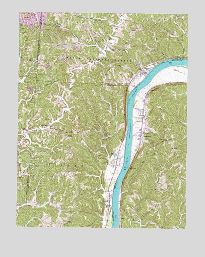
Athalia, OH USGS Topographic Map
Click on map above to begin viewing in our Map Viewer.

This topographic map contains these locations and features:
Feature Name Type Latitude Longitude GNIS ID View Map
AthaliaPopulated PlaceN38.5162°W82.3065°1075289View Map
Athalia Rural Branch Post Office (historical)Post OfficeN38.5168°W82.3068°2025777View Map
Bay BottomFlatN38.5870°W82.2860°1066450View Map
Bay HollowValleyN38.5945°W82.2740°1051217View Map
Big CreekStreamN38.5987°W82.2638°1075377View Map
Caldwell CemeteryCemeteryN38.5117°W82.2729°1550580View Map
Calloway CemeteryCemeteryN38.6215°W82.2671°1964041View Map
Center Point ChurchChurchN38.5876°W82.3707°1075554View Map
Clean ForkStreamN38.5529°W82.3104°1075585View Map
Cottonwood LandingLocaleN38.5993°W82.2546°1051222View Map
Cremeans ChapelChurchN38.5465°W82.2596°1550833View Map
Crown CityPopulated PlaceN38.5806°W82.2782°1550850View Map
Crown CityPopulated PlaceN38.5909°W82.2829°1075656View Map
Crown City CemeteryCemeteryN38.5884°W82.2868°1964043View Map
Crown City Fire DepartmentBuildingN38.5927°W82.2845°2550504View Map
Crown City Methodist ChurchChurchN38.5898°W82.2826°1068764View Map
Crown City Post OfficePost OfficeN38.5904°W82.2832°1987888View Map
Dillon ChapelChurchN38.5126°W82.3065°1075716View Map
Dirty ForkStreamN38.5559°W82.3132°1075718View Map
Double CreekStreamN38.5993°W82.2551°1075736View Map
Fairland School Number 3SchoolN38.5534°W82.3379°1080095View Map
Fairland West Middle SchoolSchoolN38.5029°W82.3374°1081289View Map
Fairview CemeteryCemeteryN38.5520°W82.2640°1551080View Map
Federal CreekStreamN38.5415°W82.2960°1075837View Map
Forest Glen ChurchChurchN38.5515°W82.3126°1075864View Map
Garland CreekStreamN38.6079°W82.3310°1075893View Map
Georges CreekStreamN38.6176°W82.3049°1075900View Map
Good HopePopulated PlaceN38.6042°W82.3138°1806787View Map
Good Hope CemeteryCemeteryN38.6079°W82.3138°1068775View Map
Good Hope ChurchChurchN38.6084°W82.3143°1075934View Map
Goose RunStreamN38.5206°W82.2990°1551257View Map
Green BottomPopulated PlaceN38.5523°W82.2838°1551283View Map
Green Bottom School (historical)SchoolN38.5654°W82.2813°1551284View Map
Greenbottom CemeteryCemeteryN38.5541°W82.2834°2586184View Map
Guyan Valley ChurchChurchN38.5587°W82.3532°1075974View Map
Halley CemeteryCemeteryN38.6245°W82.2993°1964049View Map
LesagePopulated PlaceN38.5065°W82.2985°1551780View Map
Little Double CreekStreamN38.5993°W82.2557°1051235View Map
Lower Green Bottom ChurchChurchN38.5556°W82.2829°1551959View Map
MillerPopulated PlaceN38.5368°W82.3018°1076391View Map
Miller CemeteryCemeteryN38.5395°W82.3035°1961209View Map
Miller Post Office (historical)Post OfficeN38.5362°W82.3013°2026097View Map
MillersportPopulated PlaceN38.5359°W82.2915°1552147View Map
Pilgrim ChurchChurchN38.5856°W82.2924°1076630View Map
Pine CreekStreamN38.5140°W82.3624°1076635View Map
PlatformPopulated PlaceN38.5584°W82.3513°1063425View Map
Platform Post Office (historical)Post OfficeN38.5584°W82.3513°2026010View Map
Pleasant Ridge CemeteryCemeteryN38.5367°W82.3521°1961218View Map
Pleasant Ridge ChurchChurchN38.5367°W82.3521°1076658View Map
PolkadottePopulated PlaceN38.5842°W82.3740°1076669View Map
Polkadotte Post Office (historical)Post OfficeN38.5848°W82.3735°2026012View Map
Pops LakeLakeN38.5426°W82.3032°1076676View Map
Rome Volunteer Fire Department Station 2BuildingN38.5368°W82.3023°2549131View Map
Scottown CemeteryCemeteryN38.5574°W82.3743°2729364View Map
Shoal CreekStreamN38.5773°W82.2932°1076884View Map
Simms RunStreamN38.5904°W82.2793°1051247View Map
Township of RomeCivilN38.5164°W82.3357°1086446View Map
Twomile CreekStreamN38.5118°W82.3046°1077090View Map
Village of AthaliaCivilN38.5127°W82.3096°2398003View Map
Village of Crown CityCivilN38.5900°W82.2911°2398656View Map
Vinson ChapelChurchN38.5523°W82.2654°1553347View Map
Williams CreekStreamN38.6029°W82.3132°1077194View Map
Wilma ChapelChurchN38.6037°W82.3015°1077200View Map

Note: Coordinates in the location and feature list above are referenced to NAD83 datum.


Copyright (C) 2008-2024 Ryan Niemi / Sunset Dynamics ... All Rights Reserved