TopoQuest Logo
Do you find TopoQuest useful?
Help keep TopoQuest running and adding new maps/features by donating!
Bitcoin:  19c7KJd3qBynnjoSw5npx9KScwjBe4ifkT
Litecoin:  LXs6TkuXGGXo1vDsWCkWVdjQX94eUKd6ui
Home View Maps Find Maps Find Places Resources & Links


Addison, Maine Topographic Map

USGS Map Title: Addison, ME
USGS Map MRC: 44067E6
DRG (GeoTIFF) Download: o44067e6.tif


Neighboring USGS Topographic Map Quads:


  Epping, ME  
44067F7
 

  Columbia Falls, ME  
44067F6
 

  Whitneyville, ME  
44067F5
 

  Harrington, ME  
44067E7
 

  Addison, ME  
44067E6
 

  Jonesport, ME  
44067E5
 

  Bois Bubert, ME  
44067D7
 

  Drisko Island, ME  
44067D6
 

  Great Wass Island, ME  
44067D5


Map MRC Location:

N45°
W68°
N45°
W67°
H8 H7 H6 H5 H4 H3 H2 H1
G8 G7 G6 G5 G4 G3 G2 G1
F8 F7 F6 F5 F4 F3 F2 F1
E8 E7 E6 E5 E4 E3 E2 E1
D8 D7 D6 D5 D4 D3 D2 D1
C8 C7 C6 C5 C4 C3 C2 C1
B8 B7 B6 B5 B4 B3 B2 B1
A8 A7 A6 A5 A4 A3 A2 A1
N44°
W68°
N44°
W67°

Addison, ME USGS 1:24K Topographic Map Preview:
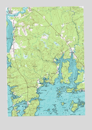
Addison, ME USGS Topographic Map
Click on map above to begin viewing in our Map Viewer.

This topographic map contains these locations and features:
Feature Name Type Latitude Longitude GNIS ID View Map
AddisonPopulated PlaceN44.6184°W67.7442°561093View Map
Addison PointCapeN44.6167°W67.7331°561094View Map
Addison Post OfficePost OfficeN44.6186°W67.7450°1909052View Map
Addison Volunteer Fire Department South AddisonBuildingN44.5243°W67.7176°2553192View Map
Addison Volunteer Fire Department Village StationBuildingN44.6184°W67.7443°2553145View Map
Bar IslandIslandN44.5095°W67.6994°561579View Map
Bare PointCapeN44.5356°W67.6914°561597View Map
Bickford PointCapeN44.5367°W67.6772°562115View Map
Bryant CornersLocaleN44.5917°W67.6642°563093View Map
Bungy RockIslandN44.5887°W67.7478°563176View Map
Burnt IslandIslandN44.5312°W67.6619°563243View Map
Cape SplitCapeN44.5009°W67.7394°563491View Map
Carrying Place CoveBayN44.5195°W67.7067°563618View Map
Carrying Place IslandIslandN44.5187°W67.6961°563623View Map
Chandler IslandIslandN44.5259°W67.6972°581399View Map
Crowley IslandIslandN44.5495°W67.6550°564623View Map
Daniel W Merritt SchoolSchoolN44.6216°W67.6975°1909133View Map
Daniels IslandIslandN44.5342°W67.6886°564768View Map
Doyle IslandIslandN44.5281°W67.6503°565264View Map
Duck LedgesBarN44.5059°W67.6756°565345View Map
East Sheep IslandIslandN44.5129°W67.6278°565684View Map
Eastern HarborBayN44.5070°W67.7253°565718View Map
Fessenden LedgeBarN44.5184°W67.6664°566119View Map
Goose IslandsIslandN44.5295°W67.6658°566919View Map
Grays BrookStreamN44.5712°W67.6589°567109View Map
Grays CoveBayN44.5692°W67.6603°567111View Map
Halftide LedgeBarN44.5051°W67.7492°567472View Map
Hall HillSummitN44.5855°W67.6525°567504View Map
Hardwood HillSummitN44.5588°W67.7054°567613View Map
Hardwood IslandIslandN44.5137°W67.6606°567619View Map
Hardwood Island LedgeBarN44.5090°W67.6583°567624View Map
Hay CreekStreamN44.5348°W67.6430°567796View Map
Hicks CreekStreamN44.5359°W67.6900°567995View Map
Hopkins GutGutN44.5295°W67.6428°568250View Map
Hopkins PointCapeN44.5292°W67.6397°568255View Map
Indian RiverPopulated PlaceN44.5720°W67.6428°568607View Map
Indian RiverStreamN44.5337°W67.6725°568608View Map
Indian River Baptist ChurchChurchN44.5729°W67.6425°1909212View Map
Indian River CemeteryCemeteryN44.5706°W67.6427°2737064View Map
Ingersoll PointCapeN44.5192°W67.7006°568629View Map
Inner Goose IslandIslandN44.5248°W67.6686°568643View Map
John White IslandIslandN44.5317°W67.7428°568890View Map
Kent CoveBayN44.5106°W67.7008°569125View Map
Knowles BrookStreamN44.5998°W67.7386°569258View Map
Lakeman PointCapeN44.5009°W67.7325°569320View Map
Lamsen BrookStreamN44.5612°W67.6722°569353View Map
Long CoveBayN44.5609°W67.7500°570198View Map
Long CreekStreamN44.5373°W67.6906°570203View Map
Long CreekStreamN44.5617°W67.7439°570204View Map
Mary Look PointCapeN44.5206°W67.7419°570867View Map
Mash HarborBayN44.5217°W67.7381°570870View Map
Mash Harbor IslandIslandN44.5270°W67.7433°570871View Map
Mayhew Library AssociationBuildingN44.6190°W67.7443°2738499View Map
Merritt CoveBayN44.5287°W67.7439°571175View Map
Merritt PointCapeN44.5231°W67.7003°571178View Map
Mill CreekStreamN44.5420°W67.6881°571327View Map
Moose NeckCapeN44.5062°W67.7128°571611View Map
Mouse IslandIslandN44.5259°W67.6419°571828View Map
Norton IslandIslandN44.5092°W67.6411°580871View Map
Norton LedgesBarN44.5009°W67.6472°572496View Map
Otter CoveBayN44.5042°W67.7244°572816View Map
Outer Goose IslandIslandN44.5220°W67.6678°572861View Map
Pomp IslandIslandN44.5137°W67.6464°573583View Map
Pomps Island LedgeBarN44.5062°W67.6536°580790View Map
Porcupine HillSummitN44.6001°W67.7124°573656View Map
Ports HarborBayN44.5337°W67.7400°581483View Map
Reef PointCapeN44.5715°W67.7497°574135View Map
Reynolds BayBayN44.5309°W67.6983°574145View Map
Sawyer IslandIslandN44.5276°W67.6658°574966View Map
Shabbit IslandIslandN44.5062°W67.6842°575264View Map
Shabbit Island LedgeBarN44.5117°W67.6742°575265View Map
Sheldrake IslandIslandN44.5290°W67.6883°575367View Map
Snare CoveBayN44.5470°W67.6336°575671View Map
Snare CreekStreamN44.5512°W67.6400°575672View Map
South AddisonPopulated PlaceN44.5134°W67.7167°575746View Map
Southwest Branch Indian RiverStreamN44.6209°W67.6467°575944View Map
Steele PointCapeN44.5379°W67.6617°576293View Map
The Basin SchoolSchoolN44.5481°W67.6717°576754View Map
The HighlandsSummitN44.6026°W67.7221°576823View Map
Three BrooksBayN44.5576°W67.7439°577049View Map
Town of AddisonCivilN44.5169°W67.7073°582316View Map
Tracy CornersLocaleN44.6215°W67.7125°580796View Map
Upper East Side SchoolSchoolN44.6023°W67.7386°577599View Map
Wallace PointCapeN44.5006°W67.7058°577805View Map
Wescogus CemeteryCemeteryN44.6206°W67.7123°2737068View Map
West Branch Pleasant RiverStreamN44.6170°W67.7450°578081View Map
West Branch Pleasant River DamDamN44.6181°W67.7454°1774723View Map
West Branch Pleasant River ReservoirReservoirN44.6181°W67.7454°1774724View Map
West RiverStreamN44.5365°W67.6678°578214View Map
West Sheep IslandIslandN44.5120°W67.6333°578223View Map
Whites PointCapeN44.5887°W67.7494°578397View Map
Wohoa BayBayN44.5295°W67.6817°581510View Map

Note: Coordinates in the location and feature list above are referenced to NAD83 datum.


Copyright (C) 2008-2025 Ryan Niemi / Sunset Dynamics ... All Rights Reserved