TopoQuest Logo
Do you find TopoQuest useful?
Help keep TopoQuest running and adding new maps/features by donating!
Bitcoin:  19c7KJd3qBynnjoSw5npx9KScwjBe4ifkT
Litecoin:  LXs6TkuXGGXo1vDsWCkWVdjQX94eUKd6ui
Home View Maps Find Maps Find Places Resources & Links


Great Wass Island, Maine Topographic Map

USGS Map Title: Great Wass Island, ME
USGS Map MRC: 44067D5
DRG (GeoTIFF) Download: o44067d5.tif


Neighboring USGS Topographic Map Quads:


  Addison, ME  
44067E6
 

  Jonesport, ME  
44067E5
 

  Roque Bluffs, ME  
44067E4
 

  Drisko Island, ME  
44067D6
 

  Great Wass Island, ME  
44067D5


Map MRC Location:

N45°
W68°
N45°
W67°
H8 H7 H6 H5 H4 H3 H2 H1
G8 G7 G6 G5 G4 G3 G2 G1
F8 F7 F6 F5 F4 F3 F2 F1
E8 E7 E6 E5 E4 E3 E2 E1
D8 D7 D6 D5 D4 D3 D2 D1
C8 C7 C6 C5 C4 C3 C2 C1
B8 B7 B6 B5 B4 B3 B2 B1
A8 A7 A6 A5 A4 A3 A2 A1
N44°
W68°
N44°
W67°

Great Wass Island, ME USGS 1:24K Topographic Map Preview:
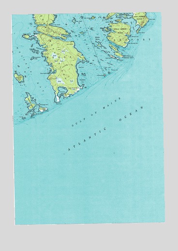
Great Wass Island, ME USGS Topographic Map
Click on map above to begin viewing in our Map Viewer.

This topographic map contains these locations and features:
Feature Name Type Latitude Longitude GNIS ID View Map
Alley PointCapeN44.4948°W67.6047°561206View Map
Big Peabody IslandIslandN44.4976°W67.5292°562218View Map
Black Duck CoveBayN44.4792°W67.5997°562433View Map
Black HeadSummitN44.4940°W67.5157°562437View Map
Black IslandIslandN44.4954°W67.5347°562446View Map
Black LedgesBarN44.4670°W67.5472°562460View Map
Brim CoveBayN44.4862°W67.5444°562975View Map
Browney IslandIslandN44.4620°W67.6192°563067View Map
Calf IslandIslandN44.4909°W67.5592°563353View Map
Cape CoveBayN44.4681°W67.5700°563468View Map
Channel RockIslandN44.4662°W67.5419°563843View Map
Crow IslandIslandN44.4959°W67.5455°564609View Map
Crow PointCapeN44.4976°W67.5436°564615View Map
Crumple IslandIslandN44.4431°W67.5989°564627View Map
Curlew RockIslandN44.4409°W67.6061°564672View Map
Deep CoveBayN44.4934°W67.6014°564953View Map
Eastern BayBayN44.4931°W67.5667°565709View Map
Fisherman IslandIslandN44.4479°W67.6105°566237View Map
Folkingham CoveBayN44.4854°W67.6042°581418View Map
Freeman RockIslandN44.4631°W67.5472°581423View Map
Great Wass IslandIslandN44.4815°W67.5897°567185View Map
Great Wass Island PreserveParkN44.4834°W67.5900°1909189View Map
Green IslandIslandN44.4809°W67.5525°567222View Map
Green IslandIslandN44.4954°W67.5725°567224View Map
Green RockIslandN44.4392°W67.6094°567260View Map
Hall CoveBayN44.4906°W67.5436°567502View Map
Hall IslandIslandN44.4898°W67.5450°567507View Map
Head HarborBayN44.4920°W67.5239°567849View Map
Knight IslandIslandN44.4792°W67.5397°569245View Map
Little Cape PointCapeN44.4731°W67.5653°569726View Map
Little Hardwood IslandIslandN44.4976°W67.5564°569816View Map
Little Peabody IslandIslandN44.4987°W67.5297°569950View Map
Little Pond HeadCapeN44.4551°W67.5689°569983View Map
Lower Herring CoveBayN44.4820°W67.5289°570506View Map
Main Channel WayChannelN44.4801°W67.5378°570668View Map
Man IslandIslandN44.4881°W67.5194°570692View Map
Mannings FarmIslandN44.4462°W67.6025°570706View Map
Mash IslandIslandN44.4990°W67.5358°570872View Map
Mink IslandIslandN44.4881°W67.5650°571429View Map
Mistake HarborBayN44.4851°W67.5530°571460View Map
Mistake IslandIslandN44.4748°W67.5350°571461View Map
Money IslandIslandN44.4948°W67.5411°571495View Map
Moose Peak LightLocaleN44.4742°W67.5317°1909276View Map
Mud HoleBayN44.4854°W67.5864°571865View Map
Mud Hole ChannelChannelN44.4715°W67.5478°571866View Map
Mud Hole PointCapeN44.4823°W67.5730°571867View Map
Mud Hole TrailTrailN44.4831°W67.5744°1909279View Map
Norton LedgeBarN44.4784°W67.6055°572494View Map
Norton PointCapeN44.4762°W67.5983°572499View Map
Pond PointCapeN44.4481°W67.5867°573609View Map
Popplestone CoveBayN44.4595°W67.5686°573652View Map
Popplestone LedgeBarN44.4740°W67.6078°573653View Map
Red HeadSummitN44.4514°W67.5811°574086View Map
Sand CoveBayN44.4867°W67.5794°574828View Map
Sand Cove NorthBayN44.4934°W67.5900°574838View Map
Seal RockIslandN44.4381°W67.6161°575120View Map
Slate IslandIslandN44.4867°W67.6122°575541View Map
Slate Island CoveBayN44.4890°W67.6022°575542View Map
Steele Harbor IslandIslandN44.4865°W67.5342°581495View Map
The Cows YardBayN44.4998°W67.5272°576787View Map
The PondLakeN44.4542°W67.5833°576904View Map
Three Falls HarborBayN44.4654°W67.5922°577054View Map
Three Falls PointCapeN44.4617°W67.5953°577055View Map
Town of BealsCivilN44.4504°W67.6016°582344View Map
Upper Herring CoveBayN44.4859°W67.5280°577616View Map
Water IslandIslandN44.4737°W67.5408°577884View Map

Note: Coordinates in the location and feature list above are referenced to NAD83 datum.


Copyright (C) 2008-2024 Ryan Niemi / Sunset Dynamics ... All Rights Reserved