TopoQuest Logo
Do you find TopoQuest useful?
Help keep TopoQuest running and adding new maps/features by donating!
Bitcoin:  19c7KJd3qBynnjoSw5npx9KScwjBe4ifkT
Litecoin:  LXs6TkuXGGXo1vDsWCkWVdjQX94eUKd6ui
Home View Maps Find Maps Find Places Resources & Links


Goldston, North Carolina Topographic Map

USGS Map Title: Goldston, NC
USGS Map MRC: 35079E3
DRG (GeoTIFF) Download: o35079e3.tif


Neighboring USGS Topographic Map Quads:


  Siler City, NC  
35079F4
 

  Siler City NE, NC  
35079F3
 

  Pittsboro, NC  
35079F2
 

  Bear Creek, NC  
35079E4
 

  Goldston, NC  
35079E3
 

  Colon, NC  
35079E2
 

  Putnam, NC  
35079D4
 

  White Hill, NC  
35079D3
 

  Sanford, NC  
35079D2


Map MRC Location:

N36°
W80°
N36°
W79°
H8 H7 H6 H5 H4 H3 H2 H1
G8 G7 G6 G5 G4 G3 G2 G1
F8 F7 F6 F5 F4 F3 F2 F1
E8 E7 E6 E5 E4 E3 E2 E1
D8 D7 D6 D5 D4 D3 D2 D1
C8 C7 C6 C5 C4 C3 C2 C1
B8 B7 B6 B5 B4 B3 B2 B1
A8 A7 A6 A5 A4 A3 A2 A1
N35°
W80°
N35°
W79°

Goldston, NC USGS 1:24K Topographic Map Preview:
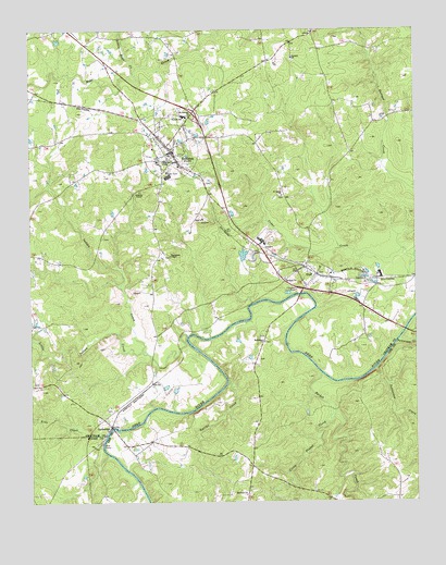
Goldston, NC USGS Topographic Map
Click on map above to begin viewing in our Map Viewer.

This topographic map contains these locations and features:
Feature Name Type Latitude Longitude GNIS ID View Map
Antioch ChurchChurchN35.6176°W79.2889°980233View Map
Bethany ChurchChurchN35.5590°W79.2920°981079View Map
Bethlehem ChurchChurchN35.5426°W79.2989°981213View Map
CarbontonPopulated PlaceN35.5204°W79.3489°982646View Map
Carbonton ChurchChurchN35.5254°W79.3489°1023535View Map
Chatham County Fire Station 11 - Goldston Rural Fire DepartmentBuildingN35.5898°W79.3327°2638076View Map
Ebenezer ChurchChurchN35.5021°W79.3053°984595View Map
GoldstonPopulated PlaceN35.5932°W79.3284°985783View Map
Goldston Area Rescue SquadBuildingN35.5893°W79.3291°2720595View Map
Goldston Post OfficePost OfficeN35.5917°W79.3265°2773887View Map
Gourley DamDamN35.5251°W79.3131°999065View Map
GulfPopulated PlaceN35.5604°W79.2817°1020575View Map
Gulf Census Designated PlaceCensusN35.5597°W79.2806°2628630View Map
Gulf Post OfficePost OfficeN35.5578°W79.2855°2774342View Map
Indian CreekStreamN35.5443°W79.3239°987349View Map
J S Walters SchoolSchoolN35.6024°W79.3247°996759View Map
Line CreekStreamN35.5179°W79.3503°988510View Map
Little Bear CreekStreamN35.6154°W79.3397°988532View Map
Little Indian CreekStreamN35.5399°W79.3370°988672View Map
Little Pocket CreekStreamN35.5224°W79.2778°988736View Map
Mount Herman ChurchChurchN35.6026°W79.3225°990397View Map
NonameReservoirN35.5251°W79.3131°999066View Map
Northwest Pocket Volunteer Fire DepartmentBuildingN35.5011°W79.2787°2639400View Map
Patterson CreekStreamN35.5427°W79.2559°991937View Map
Pocket CreekStreamN35.5340°W79.2803°992603View Map
Roberts ChapelChurchN35.5824°W79.3389°993451View Map
Roscoe PondReservoirN35.6222°W79.3653°999170View Map
Roscoe Pond DamDamN35.6218°W79.3647°999171View Map
Saint Lukes ChurchChurchN35.5813°W79.2925°993993View Map
Smiths CreekStreamN35.5324°W79.3111°995004View Map
Thompsons ChapelChurchN35.5654°W79.3292°996060View Map
Town of GoldstonCivilN35.5929°W79.3284°2406585View Map
Township of GulfCivilN35.5893°W79.3247°1026536View Map

Note: Coordinates in the location and feature list above are referenced to NAD83 datum.


Copyright (C) 2008-2025 Ryan Niemi / Sunset Dynamics ... All Rights Reserved