TopoQuest Logo
Do you find TopoQuest useful?
Help keep TopoQuest running and adding new maps/features by donating!
Bitcoin:  19c7KJd3qBynnjoSw5npx9KScwjBe4ifkT
Litecoin:  LXs6TkuXGGXo1vDsWCkWVdjQX94eUKd6ui
Home View Maps Find Maps Find Places Resources & Links


White Hill, North Carolina Topographic Map

USGS Map Title: White Hill, NC
USGS Map MRC: 35079D3
DRG (GeoTIFF) Download: o35079d3.tif


Neighboring USGS Topographic Map Quads:


  Bear Creek, NC  
35079E4
 

  Goldston, NC  
35079E3
 

  Colon, NC  
35079E2
 

  Putnam, NC  
35079D4
 

  White Hill, NC  
35079D3
 

  Sanford, NC  
35079D2
 

  Carthage, NC  
35079C4
 

  Vass, NC  
35079C3
 

  Murchisontown, NC  
35079C2


Map MRC Location:

N36°
W80°
N36°
W79°
H8 H7 H6 H5 H4 H3 H2 H1
G8 G7 G6 G5 G4 G3 G2 G1
F8 F7 F6 F5 F4 F3 F2 F1
E8 E7 E6 E5 E4 E3 E2 E1
D8 D7 D6 D5 D4 D3 D2 D1
C8 C7 C6 C5 C4 C3 C2 C1
B8 B7 B6 B5 B4 B3 B2 B1
A8 A7 A6 A5 A4 A3 A2 A1
N35°
W80°
N35°
W79°

White Hill, NC USGS 1:24K Topographic Map Preview:
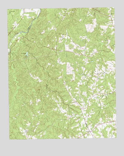
White Hill, NC USGS Topographic Map
Click on map above to begin viewing in our Map Viewer.

This topographic map contains these locations and features:
Feature Name Type Latitude Longitude GNIS ID View Map
Big Governors CreekStreamN35.4774°W79.3597°1019135View Map
Carolina Forest LakeReservoirN35.4985°W79.2847°999043View Map
Carolina Forest Lake DamDamN35.4985°W79.2847°999042View Map
Center ChurchChurchN35.4040°W79.2906°982924View Map
Crawley CreekStreamN35.4571°W79.3703°983728View Map
Dry ForkStreamN35.4479°W79.2670°984362View Map
Ebenezer ChurchChurchN35.4993°W79.3064°984594View Map
Ephesus ChurchChurchN35.3885°W79.2709°984820View Map
Euphronia ChurchChurchN35.4718°W79.3470°984844View Map
Haw BranchPopulated PlaceN35.4974°W79.3709°1020639View Map
Horseshoe ChurchChurchN35.4824°W79.3678°987143View Map
Jim Devane DamDamN35.4585°W79.3514°998991View Map
Little Governors CreekStreamN35.4696°W79.3595°988653View Map
McIntosh CreekStreamN35.4243°W79.3636°989587View Map
New Hope ChurchChurchN35.4949°W79.3056°991009View Map
Oak Grove ChurchChurchN35.4940°W79.2531°991375View Map
Pocket ChurchChurchN35.4688°W79.2584°992602View Map
Poplar Springs ChurchChurchN35.4365°W79.2870°992705View Map
Raccoon CreekStreamN35.4835°W79.2684°992964View Map
Red Branch ChurchChurchN35.3827°W79.3553°993102View Map
Township 7-PocketCivilN35.4664°W79.2865°1026873View Map
White HillPopulated PlaceN35.3818°W79.2806°997138View Map
Winding Creek LakeReservoirN35.4568°W79.3533°997469View Map

Note: Coordinates in the location and feature list above are referenced to NAD83 datum.


Copyright (C) 2008-2025 Ryan Niemi / Sunset Dynamics ... All Rights Reserved