TopoQuest Logo
Do you find TopoQuest useful?
Help keep TopoQuest running and adding new maps/features by donating!
Bitcoin:  19c7KJd3qBynnjoSw5npx9KScwjBe4ifkT
Litecoin:  LXs6TkuXGGXo1vDsWCkWVdjQX94eUKd6ui
Home View Maps Find Maps Find Places Resources & Links


Gorum, Louisiana Topographic Map

USGS Map Title: Gorum, LA
USGS Map MRC: 31092D8
DRG (GeoTIFF) Download: o31092d8.tif


Neighboring USGS Topographic Map Quads:


  Flora, LA  
31093E1
 

  Cloutierville, LA  
31092E8
 

  Aloha, LA  
31092E7
 

  Bayou Livrogne, LA  
31093D1
 

  Gorum, LA  
31092D8
 

  Lena, LA  
31092D7
 

  Simpson North, LA  
31093C1
 

  Temple, LA  
31092C8
 

  Jericho, LA  
31092C7


Map MRC Location:

N32°
W93°
N32°
W92°
H8 H7 H6 H5 H4 H3 H2 H1
G8 G7 G6 G5 G4 G3 G2 G1
F8 F7 F6 F5 F4 F3 F2 F1
E8 E7 E6 E5 E4 E3 E2 E1
D8 D7 D6 D5 D4 D3 D2 D1
C8 C7 C6 C5 C4 C3 C2 C1
B8 B7 B6 B5 B4 B3 B2 B1
A8 A7 A6 A5 A4 A3 A2 A1
N31°
W93°
N31°
W92°

Gorum, LA USGS 1:24K Topographic Map Preview:
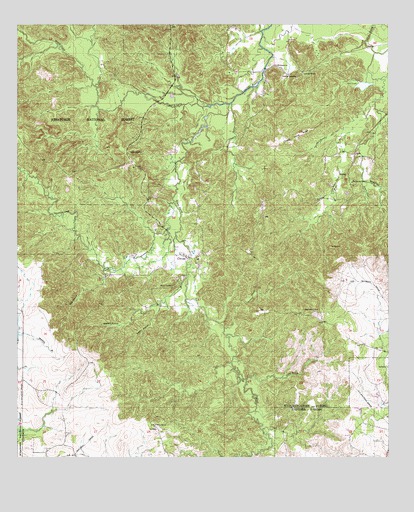
Gorum, LA USGS Topographic Map
Click on map above to begin viewing in our Map Viewer.

This topographic map contains these locations and features:
Feature Name Type Latitude Longitude GNIS ID View Map
Barbue FordCrossingN31.4874°W92.9165°548941View Map
Bay SpringChurchN31.4546°W92.8874°547001View Map
Bayou CypreStreamN31.4771°W92.9290°547015View Map
Bayou Cypre OverlookLocaleN31.4580°W92.9718°548196View Map
Bayou MauriceStreamN31.4921°W92.8793°553493View Map
Bayou PierreStreamN31.4771°W92.9288°547022View Map
Bayou Pierre OverlookLocaleN31.4574°W92.9565°548195View Map
Bolton Hill OverlookLocaleN31.4060°W92.9802°548194View Map
Botton CemeteryCemeteryN31.4629°W92.9624°547122View Map
Bynogue BranchStreamN31.4268°W92.9438°547159View Map
Chopin Camp RidgeRidgeN31.4671°W92.9068°547218View Map
Clear LakeLakeN31.4825°W92.8836°554013View Map
Croupon BayouStreamN31.4777°W92.9277°554144View Map
Emanuel CemeteryCemeteryN31.4852°W92.9057°547341View Map
Emanuel ChurchChurchN31.4866°W92.9038°547342View Map
Falls BranchStreamN31.4296°W92.9713°547351View Map
GorumPopulated PlaceN31.4330°W92.9435°547408View Map
Gorum CemeteryCemeteryN31.4246°W92.9474°547409View Map
Gorum Lookout TowerTowerN31.4174°W92.9002°548997View Map
Gorum Post OfficePost OfficeN31.4331°W92.9412°1630206View Map
Gorum Post OfficePost OfficeN31.4330°W92.9413°1630923View Map
Hait Brake (historical)SwampN31.4779°W92.9404°551661View Map
Horsehead CreekStreamN31.4488°W92.9471°554758View Map
JaniePopulated PlaceN31.4627°W92.8865°547520View Map
Johnston School (historical)SchoolN31.4541°W92.8882°549012View Map
Jowers CreekStreamN31.4552°W92.8838°547534View Map
Kisatchie Hills WildernessReserveN31.4965°W92.9969°543856View Map
Levy School (historical)SchoolN31.3943°W92.9040°549019View Map
Little Bayou PierreStreamN31.4766°W92.8813°547590View Map
Longleaf Trail Vista Picnic AreaLocaleN31.4779°W92.9971°548172View Map
Manuel School (historical)SchoolN31.4882°W92.9043°549029View Map
Mary BranchStreamN31.4780°W92.8799°547655View Map
Mayo CreekStreamN31.4463°W92.8752°547660View Map
Mora ChurchChurchN31.3846°W92.9535°547735View Map
Mossy PointCapeN31.4805°W92.8771°549034View Map
Negro Foot HillSummitN31.4043°W92.9729°549050View Map
Sampre BranchStreamN31.4127°W92.9302°547949View Map
SampusandPopulated PlaceN31.4885°W92.9129°547950View Map
Spring BranchStreamN31.3977°W92.9232°548016View Map
Sunk HillSummitN31.4363°W92.8907°548054View Map
Waldon BranchStreamN31.4193°W92.9521°556343View Map

Note: Coordinates in the location and feature list above are referenced to NAD83 datum.


Copyright (C) 2008-2024 Ryan Niemi / Sunset Dynamics ... All Rights Reserved