TopoQuest Logo
Do you find TopoQuest useful?
Help keep TopoQuest running and adding new maps/features by donating!
Bitcoin:  19c7KJd3qBynnjoSw5npx9KScwjBe4ifkT
Litecoin:  LXs6TkuXGGXo1vDsWCkWVdjQX94eUKd6ui
Home View Maps Find Maps Find Places Resources & Links


Graettinger East, Iowa Topographic Map

USGS Map Title: Graettinger East, IA
USGS Map MRC: 43094B6
DRG (GeoTIFF) Download: o43094b6.tif


Neighboring USGS Topographic Map Quads:


  Wallingford, IA  
43094C7
 

  Ingham Lake, IA  
43094C6
 

  Ringsted, IA  
43094C5
 

  Graettinger West, IA  
43094B7
 

  Graettinger East, IA  
43094B6
 

  Depew, IA  
43094B5
 

  Ayrshire, IA  
43094A7
 

  Emmetsburg, IA  
43094A6
 

  Cylinder, IA  
43094A5


Map MRC Location:

N44°
W95°
N44°
W94°
H8 H7 H6 H5 H4 H3 H2 H1
G8 G7 G6 G5 G4 G3 G2 G1
F8 F7 F6 F5 F4 F3 F2 F1
E8 E7 E6 E5 E4 E3 E2 E1
D8 D7 D6 D5 D4 D3 D2 D1
C8 C7 C6 C5 C4 C3 C2 C1
B8 B7 B6 B5 B4 B3 B2 B1
A8 A7 A6 A5 A4 A3 A2 A1
N43°
W95°
N43°
W94°

Graettinger East, IA USGS 1:24K Topographic Map Preview:
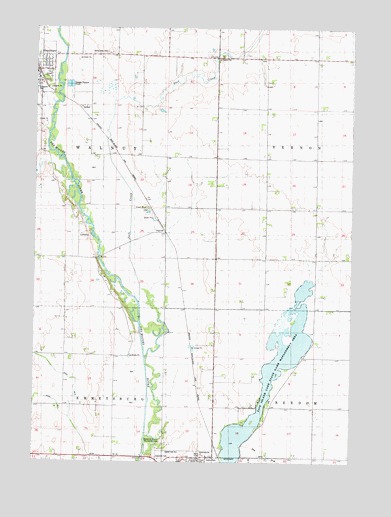
Graettinger East, IA USGS Topographic Map
Click on map above to begin viewing in our Map Viewer.

This topographic map contains these locations and features:
Feature Name Type Latitude Longitude GNIS ID View Map
Basswood County Recreation AreaParkN43.1314°W94.7030°1822735View Map
Black WalnutLocaleN43.1741°W94.7205°466308View Map
Black Walnut Post Office (historical)Post OfficeN43.1741°W94.7205°1925430View Map
Brown FarmsLocaleN43.2278°W94.6356°2729144View Map
Ellenton (historical)LocaleN43.1583°W94.6878°1925428View Map
Ellenton Post Office (historical)Post OfficeN43.1625°W94.6780°1925429View Map
Farmers Co-op ElevatorLocaleN43.2400°W94.7486°1925520View Map
Five Island LakeLakeN43.1500°W94.6669°456624View Map
Five Island Lake State Game Management AreaAreaN43.1552°W94.6514°467232View Map
GraettingerLocaleN43.2375°W94.7500°1925527View Map
Herke FarmsLocaleN43.2089°W94.6976°2728576View Map
Jack CreekStreamN43.1702°W94.7086°1823591View Map
Jack Creek FarmsLocaleN43.2393°W94.6842°2729145View Map
Lammers MuseumBuildingN43.2425°W94.7419°1925525View Map
Naig FarmLocaleN43.2482°W94.6699°2729143View Map
OsgoodPopulated PlaceN43.1933°W94.7014°459907View Map
OsgoodLocaleN43.1939°W94.7011°1925481View Map
Osgood Post Office (historical)Post OfficeN43.1933°W94.7014°1925482View Map
Plaineview FarmLocaleN43.2423°W94.6423°2729141View Map
Prairie Gold Wildlife AreaParkN43.1444°W94.6919°1925442View Map
Riverview Wildlife AreaParkN43.2139°W94.7447°1925444View Map
Roads End Prairie Wildlife AreaParkN43.1555°W94.7130°1925443View Map
Township of EmmetsburgCivilN43.1261°W94.7379°467792View Map
Township of WalnutCivilN43.2122°W94.7378°468887View Map
Valley View CemeteryCemeteryN43.2427°W94.7211°1822736View Map
West Fork Wildlife Management AreaParkN43.1833°W94.7169°1925445View Map
Westshore FarmsLocaleN43.1502°W94.6748°2728647View Map

Note: Coordinates in the location and feature list above are referenced to NAD83 datum.


Copyright (C) 2008-2025 Ryan Niemi / Sunset Dynamics ... All Rights Reserved