TopoQuest Logo
Do you find TopoQuest useful?
Help keep TopoQuest running and adding new maps/features by donating!
Bitcoin:  19c7KJd3qBynnjoSw5npx9KScwjBe4ifkT
Litecoin:  LXs6TkuXGGXo1vDsWCkWVdjQX94eUKd6ui
Home View Maps Find Maps Find Places Resources & Links


Granada, Minnesota Topographic Map

USGS Map Title: Granada, MN
USGS Map MRC: 43094F3
DRG (GeoTIFF) Download: o43094f3.tif


Neighboring USGS Topographic Map Quads:


  Truman, MN  
43094G4
 

  Truman SE, MN  
43094G3
 

  Winnebago, MN  
43094G2
 

  Fairmont, MN  
43094F4
 

  Granada, MN  
43094F3
 

  Huntley, MN  
43094F2
 

  Wilmert Lake, MN  
43094E4
 

  East Chain, MN  
43094E3
 

  Pilot Grove, MN  
43094E2


Map MRC Location:

N44°
W95°
N44°
W94°
H8 H7 H6 H5 H4 H3 H2 H1
G8 G7 G6 G5 G4 G3 G2 G1
F8 F7 F6 F5 F4 F3 F2 F1
E8 E7 E6 E5 E4 E3 E2 E1
D8 D7 D6 D5 D4 D3 D2 D1
C8 C7 C6 C5 C4 C3 C2 C1
B8 B7 B6 B5 B4 B3 B2 B1
A8 A7 A6 A5 A4 A3 A2 A1
N43°
W95°
N43°
W94°

Granada, MN USGS 1:24K Topographic Map Preview:
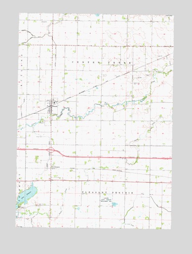
Granada, MN USGS Topographic Map
Click on map above to begin viewing in our Map Viewer.

This topographic map contains these locations and features:
Feature Name Type Latitude Longitude GNIS ID View Map
Assembly of God ChurchChurchN43.6966°W94.3483°2049498View Map
Calvary Baptist ChurchChurchN43.6916°W94.3452°2049500View Map
Center Creek CemeteryCemeteryN43.7100°W94.2822°641047View Map
City of GranadaCivilN43.6931°W94.3495°2394947View Map
Congregational ChurchChurchN43.6980°W94.3483°2049497View Map
County Ditch Number FiftyeightCanalN43.6952°W94.3719°642204View Map
County Ditch Number FortytwoCanalN43.6666°W94.3486°642083View Map
Flying Goose CampgroundsLocaleN43.6513°W94.3697°2049351View Map
GranadaPopulated PlaceN43.6955°W94.3477°644323View Map
GranadaLocaleN43.6958°W94.3483°2049494View Map
Granada Fire DepartmentBuildingN43.6952°W94.3477°2666410View Map
Granada Huntley East Chain SchoolSchoolN43.6977°W94.3458°2049502View Map
Granada LibraryBuildingN43.6955°W94.3477°2049496View Map
Granada Post OfficePost OfficeN43.6955°W94.3477°2049495View Map
Imogen Post Office (historical)Post OfficeN43.6602°W94.3455°2049419View Map
ImogenePopulated PlaceN43.6602°W94.3455°645391View Map
Interchange 107CrossingN43.6705°W94.3475°2049538View Map
Judicial Ditch Number FortyCanalN43.7261°W94.2566°645928View Map
Judicial Ditch Number OneCanalN43.7266°W94.3447°645754View Map
Judicial Ditch Number SeventyCanalN43.6666°W94.3486°645978View Map
Judicial Ditch Number TwentyeightCanalN43.7141°W94.2722°645875View Map
Lake ImogeneLakeN43.6437°W94.3666°645392View Map
Luedtke State Wildlife Management AreaParkN43.6416°W94.3027°647284View Map
Rose Lake CemeteryCemeteryN43.6380°W94.3570°650274View Map
Township of Center CreekCivilN43.7173°W94.3072°663773View Map
Township of Pleasant PrairieCivilN43.6303°W94.3079°665323View Map

Note: Coordinates in the location and feature list above are referenced to NAD83 datum.


Copyright (C) 2008-2025 Ryan Niemi / Sunset Dynamics ... All Rights Reserved