TopoQuest Logo
Do you find TopoQuest useful?
Help keep TopoQuest running and adding new maps/features by donating!
Bitcoin:  19c7KJd3qBynnjoSw5npx9KScwjBe4ifkT
Litecoin:  LXs6TkuXGGXo1vDsWCkWVdjQX94eUKd6ui
Home View Maps Find Maps Find Places Resources & Links


East Chain, Minnesota Topographic Map

USGS Map Title: East Chain, MN
USGS Map MRC: 43094E3
DRG (GeoTIFF) Download: o43094e3.tif


Neighboring USGS Topographic Map Quads:


  Fairmont, MN  
43094F4
 

  Granada, MN  
43094F3
 

  Huntley, MN  
43094F2
 

  Wilmert Lake, MN  
43094E4
 

  East Chain, MN  
43094E3
 

  Pilot Grove, MN  
43094E2
 

  Armstrong, IA  
43094D4
 

  Swea City, IA  
43094D3
 

  Ledyard, IA  
43094D2


Map MRC Location:

N44°
W95°
N44°
W94°
H8 H7 H6 H5 H4 H3 H2 H1
G8 G7 G6 G5 G4 G3 G2 G1
F8 F7 F6 F5 F4 F3 F2 F1
E8 E7 E6 E5 E4 E3 E2 E1
D8 D7 D6 D5 D4 D3 D2 D1
C8 C7 C6 C5 C4 C3 C2 C1
B8 B7 B6 B5 B4 B3 B2 B1
A8 A7 A6 A5 A4 A3 A2 A1
N43°
W95°
N43°
W94°

East Chain, MN USGS 1:24K Topographic Map Preview:
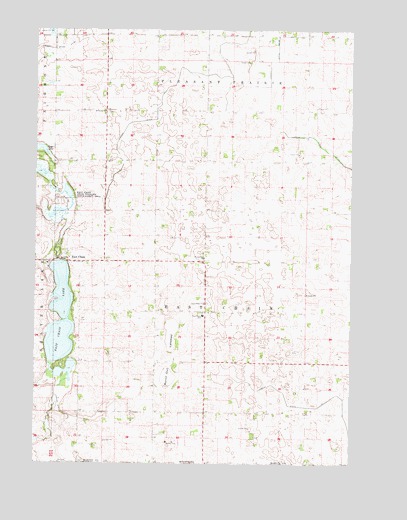
East Chain, MN USGS Topographic Map
Click on map above to begin viewing in our Map Viewer.

This topographic map contains these locations and features:
Feature Name Type Latitude Longitude GNIS ID View Map
Burnt Out LakebedFlatN43.5327°W94.3211°640674View Map
Calkins Farm CemeteryCemeteryN43.5333°W94.3169°2049525View Map
Cornfield Canyon AirportAirportN43.5986°W94.2500°2717255View Map
County Ditch Number SixtyfourCanalN43.6197°W94.3647°642251View Map
County Ditch Number SixtynineCanalN43.6163°W94.2794°642275View Map
East ChainPopulated PlaceN43.5588°W94.3652°643060View Map
East Chain ChurchChurchN43.5461°W94.3083°643061View Map
East Chain LakeLakeN43.5260°W94.3653°643062View Map
East Chain SchoolSchoolN43.5427°W94.3089°643063View Map
East Chain State Wildlife Management AreaParkN43.5755°W94.3650°643064View Map
Evangelical ChurchChurchN43.5594°W94.3086°643438View Map
Holy Family Catholic ChurchChurchN43.5577°W94.3705°2049386View Map
Judicial Ditch Number One Hundred FiveCanalN43.5147°W94.3647°645792View Map
Judicial Ditch Number TwoCanalN43.6213°W94.2980°645837View Map
Pleasant Prairie CemeteryCemeteryN43.6011°W94.3473°2049523View Map
Saint Pauls ChurchChurchN43.6016°W94.3480°650991View Map
Township of East ChainCivilN43.5437°W94.3078°664024View Map

Note: Coordinates in the location and feature list above are referenced to NAD83 datum.


Copyright (C) 2008-2024 Ryan Niemi / Sunset Dynamics ... All Rights Reserved