TopoQuest Logo
Do you find TopoQuest useful?
Help keep TopoQuest running and adding new maps/features by donating!
Bitcoin:  19c7KJd3qBynnjoSw5npx9KScwjBe4ifkT
Litecoin:  LXs6TkuXGGXo1vDsWCkWVdjQX94eUKd6ui
Home View Maps Find Maps Find Places Resources & Links


Grandmother Mountain, Idaho Topographic Map

USGS Map Title: Grandmother Mountain, ID
USGS Map MRC: 47116A1
DRG (GeoTIFF) Download: o47116a1.tif


Neighboring USGS Topographic Map Quads:


  Huckleberry Mountain, ID  
47116B2
 

  Marble Mountain, ID  
47116B1
 

  Hoyt Mountain, ID  
47115B8
 

  Merry Creek, ID  
47116A2
 

  Grandmother Mountain, ID  
47116A1
 

  Widow Mountain, ID  
47115A8
 

  Anthony Peak, ID  
46116H2
 

  Grice Ridge, ID  
46116H1
 

  Pinchot Butte, ID  
46115H8


Map MRC Location:

N48°
W117°
N48°
W116°
H8 H7 H6 H5 H4 H3 H2 H1
G8 G7 G6 G5 G4 G3 G2 G1
F8 F7 F6 F5 F4 F3 F2 F1
E8 E7 E6 E5 E4 E3 E2 E1
D8 D7 D6 D5 D4 D3 D2 D1
C8 C7 C6 C5 C4 C3 C2 C1
B8 B7 B6 B5 B4 B3 B2 B1
A8 A7 A6 A5 A4 A3 A2 A1
N47°
W117°
N47°
W116°

Grandmother Mountain, ID USGS 1:24K Topographic Map Preview:
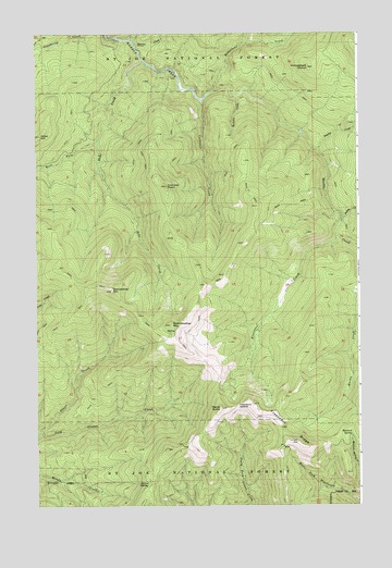
Grandmother Mountain, ID USGS Topographic Map
Click on map above to begin viewing in our Map Viewer.

This topographic map contains these locations and features:
Feature Name Type Latitude Longitude GNIS ID View Map
Cedar GroveWoodsN47.0857°W116.1135°394636View Map
Cornwall CreekStreamN47.1071°W116.0602°379761View Map
Cornwall PointSummitN47.0846°W116.0746°379762View Map
Davies CreekStreamN47.1224°W116.0868°380268View Map
Duplex CreekStreamN47.0944°W116.0157°380944View Map
Freezeout CreekStreamN47.0710°W116.0088°382046View Map
Freezeout RidgeRidgeN47.0166°W116.0243°382049View Map
Freezeout SaddleGapN47.0260°W116.0479°382050View Map
Grandfather MountainSummitN47.0571°W116.0963°382506View Map
Grandmother MountainSummitN47.0477°W116.0732°382509View Map
Hemlock SpringSpringN47.0181°W116.0038°383092View Map
Hobo Botanical AreaParkN47.0838°W116.1171°394637View Map
Hobo CreekStreamN47.1180°W116.0835°383229View Map
Hobo Creek Splash DamDamN47.0960°W116.1015°394632View Map
Hobo HillSummitN47.0982°W116.1235°383230View Map
Homestead CreekStreamN47.1091°W116.0582°383279View Map
Homestead HumpSummitN47.1160°W116.0196°383280View Map
Lockensuit SpringSpringN47.0063°W116.0820°391314View Map
Marks ButteSummitN47.0257°W116.0540°386471View Map
McGuire CreekStreamN47.1082°W116.0477°386625View Map
Placer CreekStreamN47.0191°W116.1235°388585View Map
Swing CreekStreamN47.0760°W116.0063°391783View Map
West Fork Hobo CreekStreamN47.0966°W116.1018°393116View Map

Note: Coordinates in the location and feature list above are referenced to NAD83 datum.


Copyright (C) 2008-2024 Ryan Niemi / Sunset Dynamics ... All Rights Reserved