TopoQuest Logo
Do you find TopoQuest useful?
Help keep TopoQuest running and adding new maps/features by donating!
Bitcoin:  19c7KJd3qBynnjoSw5npx9KScwjBe4ifkT
Litecoin:  LXs6TkuXGGXo1vDsWCkWVdjQX94eUKd6ui
Home View Maps Find Maps Find Places Resources & Links


Grandview Point NE, Arizona Topographic Map

USGS Map Title: Grandview Point NE, AZ
USGS Map MRC: 35111H7
DRG (GeoTIFF) Download: o35111h7.tif


Neighboring USGS Topographic Map Quads:


  Cape Royal, AZ  
36111A8
 

  Desert View, AZ  
36111A7
 

  Blue Spring, AZ  
36111A6
 

  Grandview Point, AZ  
35111H8
 

  Grandview Point NE, AZ  
35111H7
 

  Hellhole Bend, AZ  
35111H6
 

  Harbison Tank, AZ  
35111G8
 

  Peterson Flat, AZ  
35111G7
 

  Willows Camp, AZ  
35111G6


Map MRC Location:

N36°
W112°
N36°
W111°
H8 H7 H6 H5 H4 H3 H2 H1
G8 G7 G6 G5 G4 G3 G2 G1
F8 F7 F6 F5 F4 F3 F2 F1
E8 E7 E6 E5 E4 E3 E2 E1
D8 D7 D6 D5 D4 D3 D2 D1
C8 C7 C6 C5 C4 C3 C2 C1
B8 B7 B6 B5 B4 B3 B2 B1
A8 A7 A6 A5 A4 A3 A2 A1
N35°
W112°
N35°
W111°

Grandview Point NE, AZ USGS 1:24K Topographic Map Preview:
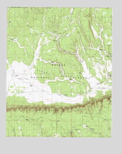
Grandview Point NE, AZ USGS Topographic Map
Click on map above to begin viewing in our Map Viewer.

This topographic map contains these locations and features:
Feature Name Type Latitude Longitude GNIS ID View Map
Badger TankReservoirN35.9679°W111.8151°946View Map
Bentonite TankReservoirN35.9851°W111.8733°1252View Map
Buff TankReservoirN35.9928°W111.7722°2091632View Map
Bull TankReservoirN35.9224°W111.7621°2178View Map
Cabin TankReservoirN35.8827°W111.7745°2342View Map
Deer TankReservoirN35.9875°W111.7996°3821View Map
Deer Tank WashStreamN35.9264°W111.7685°3822View Map
Deer Wash TankReservoirN35.9475°W111.7867°2091634View Map
Freshour TankReserveN35.9806°W111.8297°2091631View Map
Jackman TankReservoirN35.9686°W111.8668°20826View Map
Lone Tree PotholeLakeN35.8822°W111.7935°7315View Map
Long Tree PotholeLakeN35.8928°W111.7956°2091636View Map
Long Tree TankReservoirN35.8950°W111.7938°20879View Map
Lower Basin TankReservoirN35.9265°W111.7690°7449View Map
Lower Seventy-seven Bar TankReservoirN35.9305°W111.8011°7060View Map
Old Hibben TankReservoirN35.8902°W111.8155°8948View Map
Rock Lake PotholeLakeN35.8916°W111.8483°10408View Map
Saddle Horse TankReservoirN35.9348°W111.7510°10647View Map
Sand TankReservoirN35.9246°W111.8469°10899View Map
Seeley TankReservoirN35.9369°W111.7864°11057View Map
Seventy-seven Bar TankReservoirN35.9470°W111.8225°11129View Map
Upper BasinBasinN35.9364°W111.8293°13062View Map
Upper Cabin TankReservoirN35.8853°W111.7815°13069View Map
Upper Co TankReservoirN35.9525°W111.7527°13077View Map
Upper Saddle Horse TankReservoirN35.9725°W111.7646°21095View Map
Waggoner TankReservoirN35.9339°W111.8640°13261View Map
Watts TankReservoirN35.9156°W111.8078°13063View Map
Woodbridge TankReservoirN35.8798°W111.7998°13987View Map

Note: Coordinates in the location and feature list above are referenced to NAD83 datum.


Copyright (C) 2008-2024 Ryan Niemi / Sunset Dynamics ... All Rights Reserved