TopoQuest Logo
Do you find TopoQuest useful?
Help keep TopoQuest running and adding new maps/features by donating!
Bitcoin:  19c7KJd3qBynnjoSw5npx9KScwjBe4ifkT
Litecoin:  LXs6TkuXGGXo1vDsWCkWVdjQX94eUKd6ui
Home View Maps Find Maps Find Places Resources & Links


Cape Royal, Arizona Topographic Map

USGS Map Title: Cape Royal, AZ
USGS Map MRC: 36111A8
DRG (GeoTIFF) Download: o36111a8.tif


Neighboring USGS Topographic Map Quads:


  Bright Angel Point, AZ  
36112B1
 

  Walhalla Plateau, AZ  
36111B8
 

  Cape Solitude, AZ  
36111B7
 

  Phantom Ranch, AZ  
36112A1
 

  Cape Royal, AZ  
36111A8
 

  Desert View, AZ  
36111A7
 

  Tusayan East, AZ  
35112H1
 

  Grandview Point, AZ  
35111H8
 

  Grandview Point NE, AZ  
35111H7


Map MRC Location:

N37°
W112°
N37°
W111°
H8 H7 H6 H5 H4 H3 H2 H1
G8 G7 G6 G5 G4 G3 G2 G1
F8 F7 F6 F5 F4 F3 F2 F1
E8 E7 E6 E5 E4 E3 E2 E1
D8 D7 D6 D5 D4 D3 D2 D1
C8 C7 C6 C5 C4 C3 C2 C1
B8 B7 B6 B5 B4 B3 B2 B1
A8 A7 A6 A5 A4 A3 A2 A1
N36°
W112°
N36°
W111°

Cape Royal, AZ USGS 1:24K Topographic Map Preview:
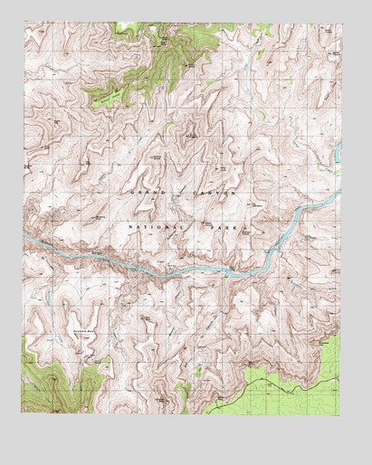
Cape Royal, AZ USGS Topographic Map
Click on map above to begin viewing in our Map Viewer.

This topographic map contains these locations and features:
Feature Name Type Latitude Longitude GNIS ID View Map
Angels GateSummitN36.0939°W111.9901°655View Map
Angels WindowArchN36.1200°W111.9469°656View Map
Apollo TempleSummitN36.1157°W111.8801°748View Map
Asbestos CanyonValleyN36.0444°W111.9437°828View Map
Ayer PointCliffN36.0300°W111.9527°902View Map
Cape RoyalCliffN36.1175°W111.9491°2451View Map
Coronado ButteSummitN36.0038°W111.9435°3282View Map
Cottonwood CreekStreamN36.0508°W111.9866°3333View Map
Dunn ButteSummitN36.0847°W111.9926°4192View Map
Escalante CreekStreamN36.0572°W111.8968°4476View Map
Freya CastleSummitN36.1112°W111.9365°4859View Map
Grandview TrailTrailN36.0189°W111.9771°5234View Map
Hall ButteSummitN36.0806°W111.9769°5524View Map
Hance CanyonValleyN36.0454°W111.9522°42725View Map
Hance CreekStreamN36.0450°W111.9529°5535View Map
Hance MineMineN36.0480°W111.9432°24059View Map
Hance RapidsRapidsN36.0459°W111.9203°5536View Map
Hance TrailTrailN36.0203°W111.9302°5537View Map
Hollenback PointSummitN36.0230°W111.8857°9185View Map
Horseshoe MesaSummitN36.0240°W111.9758°6013View Map
Krishna ShrineSummitN36.0818°W111.9495°6775View Map
Last Chance MineMineN36.0175°W111.9746°24069View Map
Mineral CanyonValleyN36.0447°W111.9393°8098View Map
Moran PointCliffN36.0055°W111.9243°8279View Map
Nevills RapidsRapidsN36.0522°W111.9027°11128View Map
Newberry ButteSummitN36.0619°W111.9730°8637View Map
O'Neill Spring (historical)SpringN36.0169°W111.9791°8852View Map
Page SpringSpringN36.0164°W111.9722°24233View Map
Papago CreekStreamN36.0461°W111.9082°9178View Map
Papago PointSummitN36.0230°W111.8854°44686View Map
Rama ShrineSummitN36.0783°W111.9238°9933View Map
Red CanyonValleyN36.0448°W111.9206°10020View Map
Seventy-Five Mile RapidsRapidsN36.0528°W111.9021°21005View Map
Seventyfive Mile CreekStreamN36.0572°W111.8974°11127View Map
Sheba TempleSummitN36.0610°W111.9294°11167View Map
Sockdolager RapidsRapidsN36.0464°W111.9543°11518View Map
Solomon TempleSummitN36.0573°W111.9155°42840View Map
The TabernacleSummitN36.0671°W111.9111°12377View Map
Venus TempleSummitN36.1237°W111.8831°13216View Map
Vishnu CreekStreamN36.0553°W111.9966°13239View Map
Vishnu TempleSummitN36.0888°W111.9357°13240View Map
Wotans ThroneSummitN36.1048°W111.9603°14013View Map
Zuni PointCliffN36.0155°W111.9127°14143View Map

Note: Coordinates in the location and feature list above are referenced to NAD83 datum.


Copyright (C) 2008-2024 Ryan Niemi / Sunset Dynamics ... All Rights Reserved