TopoQuest Logo
Do you find TopoQuest useful?
Help keep TopoQuest running and adding new maps/features by donating!
Bitcoin:  19c7KJd3qBynnjoSw5npx9KScwjBe4ifkT
Litecoin:  LXs6TkuXGGXo1vDsWCkWVdjQX94eUKd6ui
Home View Maps Find Maps Find Places Resources & Links


Gratiot, Ohio Topographic Map

USGS Map Title: Gratiot, OH
USGS Map MRC: 39082H2
DRG (GeoTIFF) Download: o39082h2.tif


Neighboring USGS Topographic Map Quads:


  Hanover, OH  
40082A3
 

  Toboso, OH  
40082A2
 

  Dresden, OH  
40082A1
 

  Glenford, OH  
39082H3
 

  Gratiot, OH  
39082H2
 

  Zanesville West, OH  
39082H1
 

  Somerset, OH  
39082G3
 

  Fultonham, OH  
39082G2
 

  Crooksville, OH  
39082G1


Map MRC Location:

N40°
W83°
N40°
W82°
H8 H7 H6 H5 H4 H3 H2 H1
G8 G7 G6 G5 G4 G3 G2 G1
F8 F7 F6 F5 F4 F3 F2 F1
E8 E7 E6 E5 E4 E3 E2 E1
D8 D7 D6 D5 D4 D3 D2 D1
C8 C7 C6 C5 C4 C3 C2 C1
B8 B7 B6 B5 B4 B3 B2 B1
A8 A7 A6 A5 A4 A3 A2 A1
N39°
W83°
N39°
W82°

Gratiot, OH USGS 1:24K Topographic Map Preview:
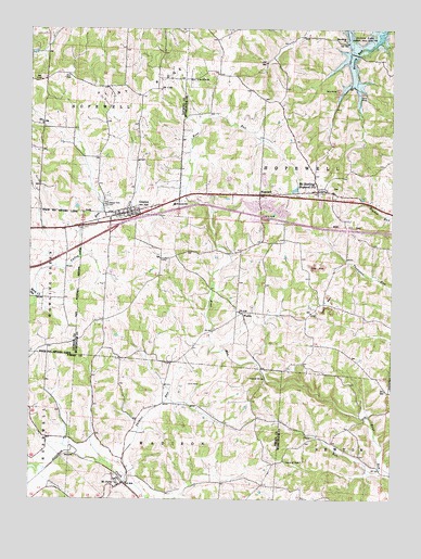
Gratiot, OH USGS Topographic Map
Click on map above to begin viewing in our Map Viewer.

This topographic map contains these locations and features:
Feature Name Type Latitude Longitude GNIS ID View Map
Asbury ChapelChurchN39.9248°W82.1774°1069037View Map
Asbury School (historical)SchoolN39.9303°W82.1788°1054552View Map
Berry RunStreamN39.9290°W82.2474°1037879View Map
Brushy Knob School (historical)SchoolN39.9353°W82.2146°1054551View Map
Church of ChristChurchN39.8853°W82.1560°1069047View Map
Dogwood School (historical)SchoolN39.8870°W82.1829°1050209View Map
Flint RidgeRidgeN39.9848°W82.2096°1040528View Map
George School (historical)SchoolN39.9265°W82.1438°1054555View Map
GratiotPopulated PlaceN39.9512°W82.2160°1041074View Map
Gratiot Post OfficePost OfficeN39.9515°W82.2165°2026085View Map
Gratiot United Methodist ChurchChurchN39.9501°W82.2154°1063869View Map
HopewellPopulated PlaceN39.9556°W82.1707°1064863View Map
Hopewell Elementary SchoolSchoolN39.9540°W82.1993°1081457View Map
Hopewell Post OfficePost OfficeN39.9556°W82.1713°2039593View Map
Hopewell Union Church (historical)ChurchN39.9565°W82.1771°1069053View Map
Humphrey School (historical)SchoolN39.9742°W82.2235°1052271View Map
Interchange 142CrossingN39.9467°W82.2221°1061337View Map
Ireland School (historical)SchoolN39.8987°W82.2174°1050210View Map
Jacks Hollow BridgeBridgeN39.9070°W82.1685°1050208View Map
Macedonia United Brethren ChurchChurchN39.9970°W82.1413°1070829View Map
Mount Olive Lutheran CemeteryCemeteryN39.9864°W82.1932°1964173View Map
Mount Olive United Brethren ChurchChurchN39.9867°W82.1915°1070854View Map
Mount PerryPopulated PlaceN39.8787°W82.2199°1048992View Map
Mount Perry CemeteryCemeteryN39.8814°W82.2207°1963637View Map
Mount Perry Post OfficePost OfficeN39.8792°W82.2193°2042297View Map
Mount SterlingPopulated PlaceN39.9565°W82.1499°1071011View Map
Mount Sterling CemeteryCemeteryN39.9581°W82.1462°1964174View Map
Mount Sterling Methodist ChurchChurchN39.9570°W82.1454°1069062View Map
National Trail Volunteer Fire DepartmentBuildingN39.9526°W82.2153°2549883View Map
Old Presbyterian CemeteryCemeteryN39.8992°W82.2101°1963647View Map
Opera (historical)Populated PlaceN39.9095°W82.1626°1054697View Map
Opera Post Office (historical)Post OfficeN39.9098°W82.1624°2039713View Map
Painter RunStreamN39.8795°W82.2165°1057909View Map
Poplar Fork CemeteryCemeteryN39.9534°W82.2235°1044686View Map
Porter AirportAirportN39.9539°W82.1834°1082742View Map
Porter LakeReservoirN39.9604°W82.1813°1077698View Map
Porter Lake DamDamN39.9601°W82.1815°1077697View Map
Poverty Run School (historical)SchoolN39.9945°W82.1396°1054554View Map
Salt RunStreamN39.8828°W82.1285°1045918View Map
Township of HopewellCivilN39.9877°W82.2443°1086464View Map
Township of HopewellCivilN39.9612°W82.1623°1086721View Map
Village of GratiotCivilN39.9515°W82.2168°2398196View Map
WesleyPopulated PlaceN39.9248°W82.1757°1063085View Map
Wise School (historical)SchoolN39.9790°W82.1696°1054553View Map

Note: Coordinates in the location and feature list above are referenced to NAD83 datum.


Copyright (C) 2008-2025 Ryan Niemi / Sunset Dynamics ... All Rights Reserved