TopoQuest Logo
Do you find TopoQuest useful?
Help keep TopoQuest running and adding new maps/features by donating!
Bitcoin:  19c7KJd3qBynnjoSw5npx9KScwjBe4ifkT
Litecoin:  LXs6TkuXGGXo1vDsWCkWVdjQX94eUKd6ui
Home View Maps Find Maps Find Places Resources & Links


Fultonham, Ohio Topographic Map

USGS Map Title: Fultonham, OH
USGS Map MRC: 39082G2
DRG (GeoTIFF) Download: o39082g2.tif


Neighboring USGS Topographic Map Quads:


  Glenford, OH  
39082H3
 

  Gratiot, OH  
39082H2
 

  Zanesville West, OH  
39082H1
 

  Somerset, OH  
39082G3
 

  Fultonham, OH  
39082G2
 

  Crooksville, OH  
39082G1
 

  Junction City, OH  
39082F3
 

  New Lexington, OH  
39082F2
 

  Deavertown, OH  
39082F1


Map MRC Location:

N40°
W83°
N40°
W82°
H8 H7 H6 H5 H4 H3 H2 H1
G8 G7 G6 G5 G4 G3 G2 G1
F8 F7 F6 F5 F4 F3 F2 F1
E8 E7 E6 E5 E4 E3 E2 E1
D8 D7 D6 D5 D4 D3 D2 D1
C8 C7 C6 C5 C4 C3 C2 C1
B8 B7 B6 B5 B4 B3 B2 B1
A8 A7 A6 A5 A4 A3 A2 A1
N39°
W83°
N39°
W82°

Fultonham, OH USGS 1:24K Topographic Map Preview:
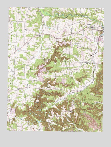
Fultonham, OH USGS Topographic Map
Click on map above to begin viewing in our Map Viewer.

This topographic map contains these locations and features:
Feature Name Type Latitude Longitude GNIS ID View Map
Avondale State Wildlife AreaParkN39.8056°W82.1276°1085191View Map
Bethel CemeteryCemeteryN39.8276°W82.1788°1963610View Map
Bush CreekStreamN39.8415°W82.1315°1038556View Map
Butcherknife CreekStreamN39.8220°W82.1374°1066623View Map
CannonPopulated PlaceN39.8273°W82.1382°1062684View Map
Clayton SchoolSchoolN39.7703°W82.1665°1039156View Map
Clover HillPopulated PlaceN39.7767°W82.1635°1060978View Map
Curren School (historical)SchoolN39.7956°W82.1885°1050189View Map
Essington LakeReservoirN39.7597°W82.2085°1078758View Map
Essington Lake DamDamN39.7584°W82.2082°1078757View Map
FultonhamPopulated PlaceN39.8556°W82.1415°1064694View Map
Fultonham CemeteryCemeteryN39.8578°W82.1385°1040727View Map
Fultonham Post OfficePost OfficeN39.8556°W82.1421°2039592View Map
Green Lawn Memory CemeteryCemeteryN39.7670°W82.2488°1963625View Map
Lick School (historical)SchoolN39.7770°W82.1904°1050190View Map
Locust Grove School (historical)SchoolN39.7609°W82.1549°1050186View Map
Madison SchoolSchoolN39.8712°W82.2090°1042894View Map
McLuney CemeteryCemeteryN39.7573°W82.1555°1043136View Map
Mount Horeb CemeteryCemeteryN39.7859°W82.1349°1043527View Map
New Lexington Water Supply ReservoirReservoirN39.7508°W82.2312°1078756View Map
Olive School (historical)SchoolN39.8256°W82.1879°1050188View Map
Perry Fish and Game Association PondReservoirN39.7634°W82.2449°1078766View Map
Perry Fish and Game Association Pond DamDamN39.7634°W82.2449°1078765View Map
Perry Reclaim Dam OneDamN39.7717°W82.1832°1078761View Map
Perry Reclaim Dam ThreeDamN39.7717°W82.2049°1078759View Map
Perry Reclaim Dam Three ImpoundmentReservoirN39.7714°W82.2076°1078760View Map
Perry Reclaim Dam TwoDamN39.7617°W82.2315°1078763View Map
Perry Reclaim Reservoir OneReservoirN39.7718°W82.1829°1078762View Map
Perry Reclaim Reservoir TwoReservoirN39.7629°W82.2320°1078764View Map
Perry State ForestForestN39.7695°W82.2082°1085192View Map
Perrydale School (historical)SchoolN39.8662°W82.1863°1050187View Map
Pike School (historical)SchoolN39.8340°W82.2340°1050192View Map
Porter School (historical)SchoolN39.8356°W82.1510°1054609View Map
RedfieldPopulated PlaceN39.7884°W82.1685°1049115View Map
Redfield Post Office (historical)Post OfficeN39.7884°W82.1679°2042187View Map
Roberts CemeteryCemeteryN39.8631°W82.1290°1045081View Map
SaltilloPopulated PlaceN39.7945°W82.1490°1065283View Map
Saltillo Post Office (historical)Post OfficeN39.7945°W82.1485°2042300View Map
SegoPopulated PlaceN39.8473°W82.2076°1065298View Map
Sego Post Office (historical)Post OfficeN39.8473°W82.2082°2042198View Map
Township of ClaytonCivilN39.7794°W82.1959°1086779View Map
Township of MadisonCivilN39.8671°W82.2017°1086784View Map
Turkey RunStreamN39.8681°W82.1974°1067022View Map
Twomile RunStreamN39.8312°W82.1343°1067031View Map
Uniontown CemeteryCemeteryN39.8570°W82.1488°1047345View Map
Unity CemeteryCemeteryN39.7923°W82.2346°1047356View Map
Unity Church (historical)ChurchN39.7923°W82.2346°1050194View Map
Village of FultonhamCivilN39.8558°W82.1424°2398931View Map
WesleyPopulated PlaceN39.8009°W82.2168°1067172View Map
Wesley ChapelChurchN39.8012°W82.2160°1047684View Map
Wesley Chapel CemeteryCemeteryN39.8009°W82.2160°1963662View Map
Wesley Post Office (historical)Post OfficeN39.8015°W82.2165°2042212View Map
Wesley School (historical)SchoolN39.8012°W82.2176°1050193View Map
WWJM-FM (New Lexington)TowerN39.7770°W82.1643°1085392View Map
Zion CemeteryCemeteryN39.8387°W82.2243°1050191View Map
Zion Methodist ChurchChurchN39.8392°W82.2240°1080489View Map

Note: Coordinates in the location and feature list above are referenced to NAD83 datum.


Copyright (C) 2008-2025 Ryan Niemi / Sunset Dynamics ... All Rights Reserved