TopoQuest Logo
Do you find TopoQuest useful?
Help keep TopoQuest running and adding new maps/features by donating!
Bitcoin:  19c7KJd3qBynnjoSw5npx9KScwjBe4ifkT
Litecoin:  LXs6TkuXGGXo1vDsWCkWVdjQX94eUKd6ui
Home View Maps Find Maps Find Places Resources & Links


Graveston, Tennessee Topographic Map

USGS Map Title: Graveston, TN
USGS Map MRC: 36083B7
DRG (GeoTIFF) Download: o36083b7.tif


Neighboring USGS Topographic Map Quads:


  White Hollow, TN  
36083C8
 

  Maynardville, TN  
36083C7
 

  Powder Springs, TN  
36083C6
 

  Big Ridge Park, TN  
36083B8
 

  Graveston, TN  
36083B7
 

  Luttrell, TN  
36083B6
 

  Fountain City, TN  
36083A8
 

  John Sevier, TN  
36083A7
 

  Mascot, TN  
36083A6


Map MRC Location:

N37°
W84°
N37°
W83°
H8 H7 H6 H5 H4 H3 H2 H1
G8 G7 G6 G5 G4 G3 G2 G1
F8 F7 F6 F5 F4 F3 F2 F1
E8 E7 E6 E5 E4 E3 E2 E1
D8 D7 D6 D5 D4 D3 D2 D1
C8 C7 C6 C5 C4 C3 C2 C1
B8 B7 B6 B5 B4 B3 B2 B1
A8 A7 A6 A5 A4 A3 A2 A1
N36°
W84°
N36°
W83°

Graveston, TN USGS 1:24K Topographic Map Preview:
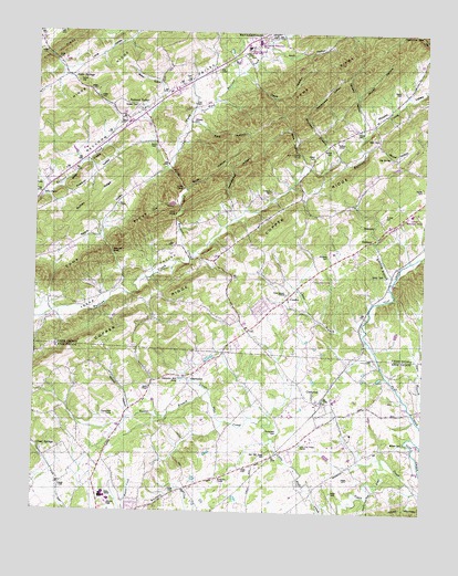
Graveston, TN USGS Topographic Map
Click on map above to begin viewing in our Map Viewer.

This topographic map contains these locations and features:
Feature Name Type Latitude Longitude GNIS ID View Map
Ailor CemeteryCemeteryN36.2201°W83.8371°1275508View Map
Ailor GapGapN36.2095°W83.8280°1275509View Map
Alder SpringsPopulated PlaceN36.2381°W83.8646°1314573View Map
Alder Springs Baptist ChurchChurchN36.2367°W83.8621°1320386View Map
Alder Springs School (historical)SchoolN36.2365°W83.8619°1320387View Map
Archer CemeteryCemeteryN36.2026°W83.7630°1275844View Map
Arick HollowValleyN36.2463°W83.8017°1304868View Map
Baker CemeteryCemeteryN36.2354°W83.7580°1276164View Map
Beeler HollowValleyN36.2351°W83.8350°1276875View Map
Big SpringSpringN36.2179°W83.7616°1277404View Map
Birch HollowValleyN36.2091°W83.8268°1277490View Map
Black HollowValleyN36.2163°W83.7889°1277577View Map
Blaine ChapelChurchN36.1573°W83.8380°1277633View Map
Bower HollowValleyN36.2214°W83.7653°1278048View Map
Bradley BranchStreamN36.1854°W83.7602°1278176View Map
Bruner HollowValleyN36.2335°W83.7721°1278667View Map
Buffalo RidgeRidgeN36.2029°W83.8596°1269401View Map
Bullrun SchoolSchoolN36.2217°W83.7788°1305523View Map
Chesney CemeteryCemeteryN36.1920°W83.7810°1280362View Map
Chesney CemeteryCemeteryN36.2087°W83.7996°1280363View Map
City of MaynardvilleCivilN36.2466°W83.8064°2405042View Map
City of PlainviewCivilN36.1810°W83.7933°2404532View Map
Clapp HollowValleyN36.2398°W83.8089°1280584View Map
Clear Branch CemeteryCemeteryN36.1817°W83.7946°1326212View Map
Clear Branch ChurchChurchN36.1817°W83.7944°1305950View Map
Comb RidgeRidgeN36.2123°W83.8169°1269486View Map
Commissioner District 1CivilN36.2374°W83.7925°2464292View Map
Commissioner District 7CivilN36.1833°W83.7977°2772144View Map
CondonPopulated PlaceN36.1812°W83.7938°1652472View Map
CorrytonPopulated PlaceN36.1537°W83.7824°1281332View Map
Corryton Baptist ChurchChurchN36.1529°W83.7844°1321466View Map
Corryton Division (historical)CensusN36.1354°W83.7663°1648805View Map
Corryton Elementary SchoolSchoolN36.1454°W83.7727°1648290View Map
Corryton Post OfficePost OfficeN36.1533°W83.7806°1651737View Map
Corum CemeteryCemeteryN36.2237°W83.7724°1281336View Map
Cove HollowValleyN36.2052°W83.8299°1306142View Map
Cox CemeteryCemeteryN36.2309°W83.8230°1281491View Map
Dale ChapelChurchN36.2048°W83.8488°1281969View Map
Damewood HollowValleyN36.2288°W83.7890°1306257View Map
Dryland BranchStreamN36.2145°W83.7827°1283034View Map
Gibbs Elementary SchoolSchoolN36.1288°W83.8549°1321543View Map
Gibbs High SchoolSchoolN36.1289°W83.8519°1321544View Map
Gibbs Middle SchoolSchoolN36.1287°W83.8521°1321545View Map
Gibbs SchoolSchoolN36.1287°W83.8530°1285336View Map
Glendale School (historical)SchoolN36.2279°W83.7655°1320397View Map
GravestonPopulated PlaceN36.1595°W83.8255°1285968View Map
Graveston Mill PondLakeN36.1597°W83.8274°1285969View Map
Hamilton GapGapN36.2495°W83.7513°1286659View Map
Hensley HollowValleyN36.2236°W83.7700°1287470View Map
Horace Maynard High SchoolSchoolN36.2462°W83.8074°1320405View Map
House Mountain (historical)Populated PlaceN36.1473°W83.7757°1312297View Map
Hubbs CemeteryCemeteryN36.2098°W83.7502°1288578View Map
Johnson CemeteryCemeteryN36.2262°W83.8257°1289570View Map
Kimberden FarmsLocaleN36.1497°W83.7942°2662804View Map
Kitts CemeteryCemeteryN36.2229°W83.7652°1290337View Map
Kitts HollowValleyN36.2263°W83.8254°1290340View Map
Lett CemeteryCemeteryN36.2500°W83.8687°1269720View Map
Little BranchStreamN36.1720°W83.7688°1291397View Map
Little Flat Creek ChurchChurchN36.1426°W83.7888°1291502View Map
Luttrell Elementary SchoolSchoolN36.2031°W83.7541°1320411View Map
Maynardville Baptist ChurchChurchN36.2490°W83.7996°1320412View Map
Maynardville Church (historical)ChurchN36.2442°W83.8088°1320413View Map
Maynardville Division (historical)CensusN36.2156°W83.8705°1648990View Map
Maynardville Elementary SchoolSchoolN36.2479°W83.8038°1320414View Map
Maynardville Police DepartmentBuildingN36.2359°W83.8247°2766003View Map
Maynardville Post OfficePost OfficeN36.2337°W83.8336°2766111View Map
Maynardville Volunteer Fire DepartmentBuildingN36.2408°W83.8169°2654478View Map
McBee CemeteryCemeteryN36.1431°W83.7557°1293080View Map
Mendenhall HollowValleyN36.2017°W83.8109°1293603View Map
Miller ChapelChurchN36.2079°W83.8730°1293937View Map
Miller KnobsSummitN36.2137°W83.8591°1293957View Map
New Friendship ChurchChurchN36.2184°W83.7905°1295482View Map
North Fork Bullrun CreekStreamN36.1909°W83.8257°1295867View Map
Old Flat Creek CemeteryCemeteryN36.1398°W83.7980°1296306View Map
Ousley CemeteryCemeteryN36.2301°W83.8432°1296527View Map
Plain View SchoolSchoolN36.1856°W83.7857°1297769View Map
Plain View School (historical)SchoolN36.1856°W83.7857°1320425View Map
Pleasant Grove CemeteryCemeteryN36.1940°W83.8313°1326222View Map
Pleasant Grove SchoolSchoolN36.1934°W83.8327°1297839View Map
Pleasant ValleyPopulated PlaceN36.1945°W83.8299°1647532View Map
Potato ValleyValleyN36.2235°W83.7694°1303526View Map
Prospect School (historical)SchoolN36.2162°W83.7874°1320427View Map
Raccoon ValleyPopulated PlaceN36.2295°W83.8419°1298803View Map
Raccoon Valley School (historical)SchoolN36.2131°W83.8644°1320428View Map
Rockydale CemeteryCemeteryN36.1454°W83.7966°1299946View Map
Rockydale ChurchChurchN36.1340°W83.8149°1299947View Map
Rural / Metro Fire Department Knoxville 33BuildingN36.1511°W83.7820°2654559View Map
Sharp CemeteryCemeteryN36.1870°W83.7627°1301259View Map
Sharp CemeteryCemeteryN36.2173°W83.7880°1301260View Map
Stover GapGapN36.1934°W83.8510°1271558View Map
Tabler BranchStreamN36.1562°W83.8188°1272028View Map
Thunder Hollow DamDamN36.2051°W83.8299°1302424View Map
Thunder Hollow LakeReservoirN36.2052°W83.8313°1302425View Map
Turner CemeteryCemeteryN36.2373°W83.8621°1304204View Map
Union ChurchChurchN36.2029°W83.8305°1273206View Map
Union County Rescue SquadBuildingN36.2261°W83.8460°2654340View Map
Union County Sherriff's DepartmentBuildingN36.2484°W83.8080°2766037View Map
Wood HollowValleyN36.1519°W83.8441°1275021View Map
Woodburn (historical)Populated PlaceN36.1834°W83.8132°1311812View Map
Wyrick CemeteryCemeteryN36.2198°W83.7805°1275217View Map

Note: Coordinates in the location and feature list above are referenced to NAD83 datum.


Copyright (C) 2008-2025 Ryan Niemi / Sunset Dynamics ... All Rights Reserved