TopoQuest Logo
Do you find TopoQuest useful?
Help keep TopoQuest running and adding new maps/features by donating!
Bitcoin:  19c7KJd3qBynnjoSw5npx9KScwjBe4ifkT
Litecoin:  LXs6TkuXGGXo1vDsWCkWVdjQX94eUKd6ui
Home View Maps Find Maps Find Places Resources & Links


Green Bay East, Wisconsin Topographic Map

USGS Map Title: Green Bay East, WI
USGS Map MRC: 44087E8
DRG (GeoTIFF) Download: o44087e8.tif


Neighboring USGS Topographic Map Quads:


  Suamico, WI  
44088F1
 

  Little Tail Point, WI  
44087F8
 

  Dyckesville, WI  
44087F7
 

  Green Bay West, WI  
44088E1
 

  Green Bay East, WI  
44087E8
 

  New Franken, WI  
44087E7
 

  De Pere, WI  
44088D1
 

  Bellevue, WI  
44087D8
 

  Poland, WI  
44087D7


Map MRC Location:

N45°
W88°
N45°
W87°
H8 H7 H6 H5 H4 H3 H2 H1
G8 G7 G6 G5 G4 G3 G2 G1
F8 F7 F6 F5 F4 F3 F2 F1
E8 E7 E6 E5 E4 E3 E2 E1
D8 D7 D6 D5 D4 D3 D2 D1
C8 C7 C6 C5 C4 C3 C2 C1
B8 B7 B6 B5 B4 B3 B2 B1
A8 A7 A6 A5 A4 A3 A2 A1
N44°
W88°
N44°
W87°

Green Bay East, WI USGS 1:24K Topographic Map Preview:
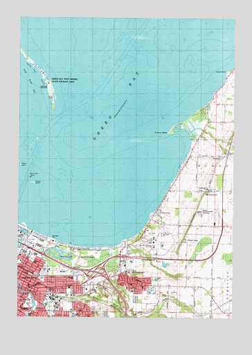
Green Bay East, WI USGS Topographic Map
Click on map above to begin viewing in our Map Viewer.

This topographic map contains these locations and features:
Feature Name Type Latitude Longitude GNIS ID View Map
A and V Terrace GardensPopulated PlaceN44.5186°W87.9661°2631380View Map
Aldo Santaga StadiumLocaleN44.5289°W87.9094°2438469View Map
Baird CreekStreamN44.5050°W87.9898°1561096View Map
Baird Elementary SchoolSchoolN44.5111°W87.9335°1578131View Map
Bay Beach ParkParkN44.5325°W87.9801°1561317View Map
Bay Ridge School (historical)SchoolN44.5414°W87.8982°1838096View Map
Bay SettlementPopulated PlaceN44.5530°W87.8907°1561321View Map
Bayshore CenterBuildingN44.5347°W87.9295°1838097View Map
Bayside AcademySchoolN44.5147°W87.9093°2716269View Map
Bayview ParkParkN44.5230°W87.9918°1578018View Map
Birds Tree IslandIslandN44.5558°W87.9937°1578020View Map
Blessed Sacrament Roman Catholic ChurchChurchN44.5180°W87.9998°1964311View Map
Brown County JailBuildingN44.5227°W87.9313°2759458View Map
Brown County Mental Health CenterHospitalN44.5189°W87.9373°1577449View Map
Cedar Creek School (historical)SchoolN44.5119°W87.9368°1838107View Map
Chapel RidgePopulated PlaceN44.5317°W87.9045°1562944View Map
City of Green BayCivilN44.5207°W87.9854°1583309View Map
City StadiumLocaleN44.5078°W87.9931°2351144View Map
Congregation Gnesses Israel TempleChurchN44.5050°W87.9970°1964320View Map
County Home CemeteryCemeteryN44.5242°W87.9270°1563450View Map
Danz Elementary SchoolSchoolN44.5088°W87.9689°1577477View Map
Danz ParkParkN44.5094°W87.9732°1563710View Map
David A Cofrin LibraryBuildingN44.5314°W87.9215°1838113View Map
East High SchoolSchoolN44.5070°W87.9935°1564334View Map
Eastman ParkParkN44.5175°W87.9926°1578019View Map
Farlin ParkParkN44.5161°W87.9862°1564857View Map
Fire Station Number 5BuildingN44.5025°W87.9779°1964325View Map
Frying Pan ShoalBarN44.5644°W87.9687°1577397View Map
Grassy IslandIslandN44.5564°W87.9915°1565775View Map
Green Bay Community CenterBuildingN44.5119°W87.9979°1964335View Map
Green Bay Fire Department Station 7BuildingN44.5135°W87.9076°2697524View Map
Green Bay Trinity Lutheran SchoolSchoolN44.5020°W87.9789°2716821View Map
Green Bay West Shores State Wildlife AreaParkN44.5986°W87.9834°1568597View Map
Haevers CornersPopulated PlaceN44.5128°W87.9779°1565961View Map
Hagemeister Park (historical)ParkN44.5072°W87.9933°2351143View Map
Henry S Baird ParkParkN44.5108°W87.9348°1838135View Map
Holy Cross CemeteryCemeteryN44.5542°W87.8820°1566591View Map
Holy Cross Elementary SchoolSchoolN44.5533°W87.8895°1577451View Map
Interchange 185CrossingN44.5189°W87.9543°1877166View Map
Interchange 187CrossingN44.5269°W87.9876°1877167View Map
Joannes FieldParkN44.5044°W87.9925°2128115View Map
Joannes ParkParkN44.5050°W87.9936°1567184View Map
John M Rose HallBuildingN44.5314°W87.9229°1838143View Map
Kennedy ParkParkN44.5167°W87.9659°1567411View Map
L G Wood HallBuildingN44.5314°W87.9234°1838144View Map
Lakeside ParkParkN44.5378°W87.9693°1578051View Map
Long Tail PointCapeN44.5867°W87.9804°1568596View Map
Meyer ParkParkN44.5017°W87.9945°1569393View Map
Nicolet Elementary SchoolSchoolN44.5129°W87.9936°1570289View Map
Nicolet Memorial GardensCemeteryN44.5439°W87.8937°1577452View Map
North Baird Mobile Home ParkPopulated PlaceN44.5192°W87.9850°2631382View Map
North Branch Kellogg Public LibraryBuildingN44.5133°W87.9943°1964339View Map
Oak Grove SchoolSchoolN44.5025°W87.9840°1570630View Map
Our Saviour Lutheran ChurchChurchN44.5019°W87.9787°1964341View Map
Phoenix Sports CenterBuildingN44.5300°W87.9162°1838161View Map
Point SableCapeN44.5775°W87.9129°1577481View Map
Preble High SchoolSchoolN44.5005°W87.9673°1577450View Map
Quincy Street Wastewater Treatment PlantLocaleN44.5347°W87.9975°2351846View Map
Red Smith K - 8 SchoolSchoolN44.5452°W87.9051°2716902View Map
Roosevelt SchoolSchoolN44.5153°W87.9776°1572585View Map
Saint Peter and Paul Roman Catholic ChurchChurchN44.5128°W87.9907°1964356View Map
Saints Peter and Paul SchoolSchoolN44.5133°W87.9898°1573608View Map
School Number SixSchoolN44.5028°W87.8865°1573810View Map
Shorewood Golf CourseLocaleN44.5344°W87.9229°1581341View Map
Sullivan Elementary SchoolSchoolN44.5033°W87.9889°1838186View Map
Theatre HallBuildingN44.5328°W87.9215°1838187View Map
Tower East Industrial ParkLocaleN44.5194°W87.9765°1838189View Map
Town of ScottCivilN44.6126°W87.8813°1584113View Map
University of Wisconsin - Green BaySchoolN44.5323°W87.9199°1575940View Map
University of Wisconsin - Green bay Police DepartmentBuildingN44.5305°W87.9216°2759974View Map
University UnionBuildingN44.5325°W87.9201°1838192View Map
Vincent PointCapeN44.6030°W87.8793°1576102View Map
Washington Middle SchoolSchoolN44.5042°W87.9978°1838195View Map
Weidner Center for the Performing ArtsBuildingN44.5336°W87.9229°1838198View Map
WequiockPopulated PlaceN44.5675°W87.8812°1576431View Map
WGBW-FM (Green Bay)TowerN44.5230°W87.9193°1582386View Map
Willow IslandIslandN44.5633°W87.9990°1577392View Map

Note: Coordinates in the location and feature list above are referenced to NAD83 datum.


Copyright (C) 2008-2024 Ryan Niemi / Sunset Dynamics ... All Rights Reserved