TopoQuest Logo
Do you find TopoQuest useful?
Help keep TopoQuest running and adding new maps/features by donating!
Bitcoin:  19c7KJd3qBynnjoSw5npx9KScwjBe4ifkT
Litecoin:  LXs6TkuXGGXo1vDsWCkWVdjQX94eUKd6ui
Home View Maps Find Maps Find Places Resources & Links


Poland, Wisconsin Topographic Map

USGS Map Title: Poland, WI
USGS Map MRC: 44087D7
DRG (GeoTIFF) Download: o44087d7.tif


Neighboring USGS Topographic Map Quads:


  Green Bay East, WI  
44087E8
 

  New Franken, WI  
44087E7
 

  Luxemburg, WI  
44087E6
 

  Bellevue, WI  
44087D8
 

  Poland, WI  
44087D7
 

  Stangelville, WI  
44087D6
 

  Morrison, WI  
44087C8
 

  Denmark, WI  
44087C7
 

  Larrabee, WI  
44087C6


Map MRC Location:

N45°
W88°
N45°
W87°
H8 H7 H6 H5 H4 H3 H2 H1
G8 G7 G6 G5 G4 G3 G2 G1
F8 F7 F6 F5 F4 F3 F2 F1
E8 E7 E6 E5 E4 E3 E2 E1
D8 D7 D6 D5 D4 D3 D2 D1
C8 C7 C6 C5 C4 C3 C2 C1
B8 B7 B6 B5 B4 B3 B2 B1
A8 A7 A6 A5 A4 A3 A2 A1
N44°
W88°
N44°
W87°

Poland, WI USGS 1:24K Topographic Map Preview:
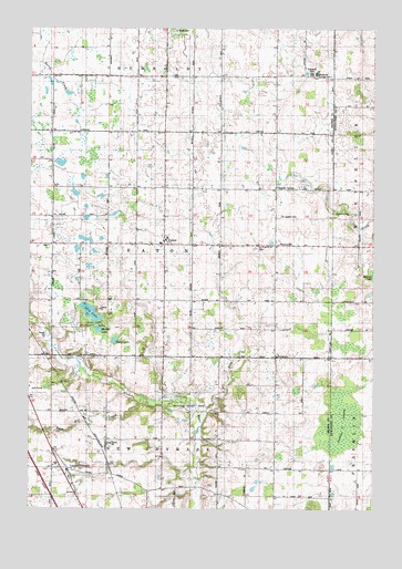
Poland, WI USGS Topographic Map
Click on map above to begin viewing in our Map Viewer.

This topographic map contains these locations and features:
Feature Name Type Latitude Longitude GNIS ID View Map
BuckmanPopulated PlaceN44.4144°W87.7854°1562338View Map
Buresh FarmsLocaleN44.4453°W87.7625°2710604View Map
Coppens CornerPopulated PlaceN44.4583°W87.7856°1577558View Map
Davister FarmLocaleN44.4814°W87.7575°2710606View Map
Denmark Volunteer Fire Department 2BuildingN44.4451°W87.8253°2697528View Map
Emanuel ChurchChurchN44.4433°W87.7906°1564605View Map
Fontenoy School (historical)SchoolN44.3758°W87.7956°1838128View Map
Hallada LakeLakeN44.4350°W87.7504°1565988View Map
HenrysvillePopulated PlaceN44.4439°W87.7859°1577638View Map
King CreekStreamN44.4003°W87.8126°1567496View Map
Langes CornersPopulated PlaceN44.3855°W87.8609°1581156View Map
Lilly LakeLakeN44.4260°W87.8527°1568038View Map
Lilly Lake CemeteryCemeteryN44.4436°W87.8681°1838148View Map
Lilly Lake County ParkParkN44.4230°W87.8509°1568041View Map
Lynch School (historical)SchoolN44.3997°W87.7912°1838149View Map
Martyville DairyLocaleN44.4989°W87.7639°2710614View Map
Middle LakeLakeN44.4216°W87.8499°1569425View Map
Neshota County ParkParkN44.4022°W87.8134°1570189View Map
PolandPopulated PlaceN44.4436°W87.8262°1571732View Map
Rosik Century FarmsLocaleN44.3897°W87.8681°2705019View Map
Saint Josephs CemeteryCemeteryN44.4511°W87.7840°1573186View Map
Section Seven SwampSwampN44.3978°W87.7606°1573885View Map
Third LakeLakeN44.4188°W87.8442°1575355View Map
Town of EatonCivilN44.4438°W87.8261°1583121View Map
Twin Hill CreekStreamN44.4042°W87.8343°1575781View Map
Twinbrook FarmsLocaleN44.4006°W87.8461°2705123View Map
Water Division School (historical)SchoolN44.4878°W87.8165°1838196View Map
West Eaton School (historical)SchoolN44.4508°W87.8670°1838199View Map

Note: Coordinates in the location and feature list above are referenced to NAD83 datum.


Copyright (C) 2008-2024 Ryan Niemi / Sunset Dynamics ... All Rights Reserved