TopoQuest Logo
Do you find TopoQuest useful?
Help keep TopoQuest running and adding new maps/features by donating!
Bitcoin:  19c7KJd3qBynnjoSw5npx9KScwjBe4ifkT
Litecoin:  LXs6TkuXGGXo1vDsWCkWVdjQX94eUKd6ui
Home View Maps Find Maps Find Places Resources & Links


Green Island, Iowa Topographic Map

USGS Map Title: Green Island, IA
USGS Map MRC: 42090B3
DRG (GeoTIFF) Download: o42090b3.tif


Neighboring USGS Topographic Map Quads:


  Bellevue, IA  
42090C4
 

  Hanover, IL  
42090C3
 

  Elizabeth, IL  
42090C2
 

  Springbrook, IA  
42090B4
 

  Green Island, IA  
42090B3
 

  Blackhawk, IL  
42090B2
 

  Preston, IA  
42090A4
 

  Miles, IA  
42090A3
 

  Savanna, IL  
42090A2


Map MRC Location:

N43°
W91°
N43°
W90°
H8 H7 H6 H5 H4 H3 H2 H1
G8 G7 G6 G5 G4 G3 G2 G1
F8 F7 F6 F5 F4 F3 F2 F1
E8 E7 E6 E5 E4 E3 E2 E1
D8 D7 D6 D5 D4 D3 D2 D1
C8 C7 C6 C5 C4 C3 C2 C1
B8 B7 B6 B5 B4 B3 B2 B1
A8 A7 A6 A5 A4 A3 A2 A1
N42°
W91°
N42°
W90°

Green Island, IA USGS 1:24K Topographic Map Preview:
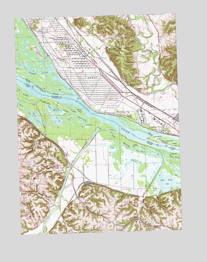
Green Island, IA USGS Topographic Map
Click on map above to begin viewing in our Map Viewer.

This topographic map contains these locations and features:
Feature Name Type Latitude Longitude GNIS ID View Map
Apple River IslandIslandN42.1756°W90.2540°403581View Map
Bar SloughStreamN42.1922°W90.3196°454352View Map
Blakes LakeLakeN42.1582°W90.2715°2747057View Map
Bonnie LakeLakeN42.1969°W90.3678°454750View Map
Bowman IslandIslandN42.2095°W90.3705°2730057View Map
Bowman SloughGutN42.2092°W90.3721°2761279View Map
Brickhouse SloughGutN42.1786°W90.2532°2730061View Map
Brinksburg (historical)Populated PlaceN42.1950°W90.3115°1815766View Map
Crooked SloughStreamN42.2047°W90.3293°406821View Map
Densmore LakeLakeN42.1593°W90.2842°455884View Map
Eggers HollowValleyN42.1310°W90.3612°456251View Map
Fish LakeLakeN42.1680°W90.3014°456615View Map
Flat LakeLakeN42.1907°W90.3456°456629View Map
Friday HollowValleyN42.1341°W90.3445°456778View Map
Golden LakeLakeN42.1970°W90.3482°456951View Map
Goose LakeLakeN42.1916°W90.3338°456973View Map
Grand View SchoolSchoolN42.1647°W90.3521°457029View Map
Green IslandPopulated PlaceN42.1536°W90.3221°457102View Map
Green IslandLocaleN42.1536°W90.3221°2000891View Map
Green Island Post OfficePost OfficeN42.1536°W90.3221°2000892View Map
Green Island Wildlife Management AreaParkN42.1663°W90.2956°2730058View Map
Hanover Bluff Nature PreserveParkN42.2247°W90.2946°2009734View Map
Island Number 254IslandN42.2078°W90.3343°1695206View Map
Island Number 256IslandN42.1836°W90.2804°1695192View Map
Jackson LakeLakeN42.1958°W90.3463°457894View Map
Kennedy BarBarN42.1784°W90.2660°411398View Map
Lamborn HollowValleyN42.1425°W90.3486°458211View Map
Little Sawmill LakeLakeN42.1727°W90.2827°458500View Map
Lost MoundSummitN42.2061°W90.2799°412662View Map
Lost Mound CemeteryCemeteryN42.2042°W90.2621°412663View Map
Lost Mound School (historical)SchoolN42.2036°W90.2737°412664View Map
Maquoketa RiverStreamN42.1884°W90.3096°458791View Map
Mooney HollowValleyN42.1456°W90.3305°459207View Map
Morse IslandIslandN42.1947°W90.3260°459251View Map
Muskrat HollowValleyN42.1424°W90.2808°459418View Map
Nobis School (historical)SchoolN42.2392°W90.3176°1695214View Map
ReecevillePopulated PlaceN42.1267°W90.2985°464713View Map
Reeseville CemeteryCemeteryN42.1295°W90.3018°460570View Map
Savanna Army DepotMilitaryN42.2226°W90.3263°2512002View Map
Savanna Army Depot (historical)MilitaryN42.2092°W90.3139°1987476View Map
Sawmill LakeLakeN42.1678°W90.2735°461438View Map
Schlect HollowValleyN42.1595°W90.3404°461463View Map
Shoe Craft HollowValleyN42.1442°W90.2698°461584View Map
Smith CreekStreamN42.1661°W90.2626°461692View Map
Smith Creek SchoolSchoolN42.1275°W90.2671°461697View Map
Snag SloughStreamN42.1709°W90.2726°461720View Map
Snider LakeLakeN42.1822°W90.3023°461724View Map
Storybrook Country ClubLocaleN42.2356°W90.2621°1815809View Map
Sugar Camp HollowValleyN42.1821°W90.3564°462048View Map
Township of HanoverCivilN42.2435°W90.3087°429106View Map
Township of WashingtonCivilN42.1622°W90.3672°468921View Map
Twin LakesLakeN42.1879°W90.3228°462400View Map
Twin SpringsPopulated PlaceN42.1320°W90.2837°464779View Map
Upper Brown LakeLakeN42.1534°W90.2561°462491View Map
Western PondLakeN42.1924°W90.3596°462934View Map
WhittonPopulated PlaceN42.2259°W90.3085°423307View Map

Note: Coordinates in the location and feature list above are referenced to NAD83 datum.


Copyright (C) 2008-2025 Ryan Niemi / Sunset Dynamics ... All Rights Reserved