TopoQuest Logo
Do you find TopoQuest useful?
Help keep TopoQuest running and adding new maps/features by donating!
Bitcoin:  19c7KJd3qBynnjoSw5npx9KScwjBe4ifkT
Litecoin:  LXs6TkuXGGXo1vDsWCkWVdjQX94eUKd6ui
Home View Maps Find Maps Find Places Resources & Links


Greencastle, Pennsylvania Topographic Map

USGS Map Title: Greencastle, PA
USGS Map MRC: 39077G6
DRG (GeoTIFF) Download: o39077g6.tif


Neighboring USGS Topographic Map Quads:


  Saint Thomas, PA  
39077H7
 

  Chambersburg, PA  
39077H6
 

  Scotland, PA  
39077H5
 

  Williamson, PA  
39077G7
 

  Greencastle, PA  
39077G6
 

  Waynesboro, PA  
39077G5
 

  Mason and Dixon, PA  
39077F7
 

  Hagerstown, MD  
39077F6
 

  Smithsburg, MD  
39077F5


Map MRC Location:

N40°
W78°
N40°
W77°
H8 H7 H6 H5 H4 H3 H2 H1
G8 G7 G6 G5 G4 G3 G2 G1
F8 F7 F6 F5 F4 F3 F2 F1
E8 E7 E6 E5 E4 E3 E2 E1
D8 D7 D6 D5 D4 D3 D2 D1
C8 C7 C6 C5 C4 C3 C2 C1
B8 B7 B6 B5 B4 B3 B2 B1
A8 A7 A6 A5 A4 A3 A2 A1
N39°
W78°
N39°
W77°

Greencastle, PA USGS 1:24K Topographic Map Preview:
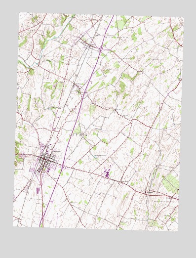
Greencastle, PA USGS Topographic Map
Click on map above to begin viewing in our Map Viewer.

This topographic map contains these locations and features:
Feature Name Type Latitude Longitude GNIS ID View Map
Antrim Mennonite SchoolSchoolN39.8154°W77.7019°1207330View Map
Borough of GreencastleCivilN39.7907°W77.7267°1215244View Map
Brown MillsPopulated PlaceN39.8298°W77.7017°1203166View Map
Brown's Mill Poultry FarmLocaleN39.8453°W77.6972°2517035View Map
Canebrake SchoolSchoolN39.7651°W77.7067°1171154View Map
CashtownPopulated PlaceN39.8679°W77.7364°1203229View Map
Cedar Hill CemeteryCemeteryN39.7924°W77.7436°1171379View Map
Clay HillPopulated PlaceN39.8198°W77.6747°1171943View Map
Clay Hill SchoolSchoolN39.8159°W77.6689°1171944View Map
Cold SpringsSpringN39.8087°W77.6850°1172164View Map
Cumberland Valley AirstripAirportN39.8176°W77.7255°1193752View Map
GreencastlePopulated PlaceN39.7904°W77.7278°1176140View Map
Greencastle Antrim Elementary SchoolSchoolN39.7809°W77.7214°1207333View Map
Greencastle Antrim Middle SchoolSchoolN39.7829°W77.7247°1207332View Map
Greencastle Antrim Senior High SchoolSchoolN39.7843°W77.7239°1207331View Map
Greencastle Police DepartmentBuildingN39.7911°W77.7256°2780504View Map
Greencastle Post OfficePost OfficeN39.7900°W77.7259°2779752View Map
Greencastle ReservoirReservoirN39.7924°W77.6889°1176141View Map
Hillgrove SchoolSchoolN39.7548°W77.6680°1177100View Map
HousumPopulated PlaceN39.8704°W77.7322°1177515View Map
Joshua W Sharpe HouseBuildingN39.7642°W77.6536°2115128View Map
KauffmanPopulated PlaceN39.8340°W77.7061°1178250View Map
MarionPopulated PlaceN39.8573°W77.6953°1180410View Map
Marion Census Designated PlaceCensusN39.8607°W77.7016°2633812View Map
Marion Post OfficePost OfficeN39.8586°W77.6995°2779637View Map
Marion Volunteer Fire Department - Company 8BuildingN39.8622°W77.7054°2645053View Map
MilnorPopulated PlaceN39.7548°W77.7450°1181296View Map
Moss SpringSpringN39.7920°W77.7167°1202298View Map
Muddy Run SpringSpringN39.8431°W77.6803°1182060View Map
Oak SpringSpringN39.7995°W77.6922°1202299View Map
PolktownPopulated PlaceN39.7598°W77.6305°1184212View Map
Rescue Hose Fire Department - Company 3BuildingN39.7752°W77.7284°2645038View Map
Rock Hill SchoolSchoolN39.8384°W77.6255°1185260View Map
Shady GrovePopulated PlaceN39.7779°W77.6686°1187301View Map
Shady Grove Elementary SchoolSchoolN39.7801°W77.6789°1214738View Map
Shady Grove Post OfficePost OfficeN39.7785°W77.6729°2779593View Map
South Antrim Elementary SchoolSchoolN39.7751°W77.7280°1207334View Map
Tayamentasachta SpringSpringN39.7790°W77.7197°1209378View Map
Township of AntrimCivilN39.7503°W77.7259°1216459View Map
WaynecastlePopulated PlaceN39.7729°W77.6500°1190720View Map
WKSL-FM (Greencastle-West)TowerN39.7915°W77.6755°1200141View Map
ZentmyerPopulated PlaceN39.8418°W77.6405°1212855View Map
ZullingerPopulated PlaceN39.7701°W77.6297°1192033View Map

Note: Coordinates in the location and feature list above are referenced to NAD83 datum.


Copyright (C) 2008-2024 Ryan Niemi / Sunset Dynamics ... All Rights Reserved