TopoQuest Logo
Do you find TopoQuest useful?
Help keep TopoQuest running and adding new maps/features by donating!
Bitcoin:  19c7KJd3qBynnjoSw5npx9KScwjBe4ifkT
Litecoin:  LXs6TkuXGGXo1vDsWCkWVdjQX94eUKd6ui
Home View Maps Find Maps Find Places Resources & Links


Waynesboro, Pennsylvania Topographic Map

USGS Map Title: Waynesboro, PA
USGS Map MRC: 39077G5
DRG (GeoTIFF) Download: o39077g5.tif


Neighboring USGS Topographic Map Quads:


  Chambersburg, PA  
39077H6
 

  Scotland, PA  
39077H5
 

  Caledonia Park, PA  
39077H4
 

  Greencastle, PA  
39077G6
 

  Waynesboro, PA  
39077G5
 

  Iron Springs, PA  
39077G4
 

  Hagerstown, MD  
39077F6
 

  Smithsburg, MD  
39077F5
 

  Blue Ridge Summit, PA  
39077F4


Map MRC Location:

N40°
W78°
N40°
W77°
H8 H7 H6 H5 H4 H3 H2 H1
G8 G7 G6 G5 G4 G3 G2 G1
F8 F7 F6 F5 F4 F3 F2 F1
E8 E7 E6 E5 E4 E3 E2 E1
D8 D7 D6 D5 D4 D3 D2 D1
C8 C7 C6 C5 C4 C3 C2 C1
B8 B7 B6 B5 B4 B3 B2 B1
A8 A7 A6 A5 A4 A3 A2 A1
N39°
W78°
N39°
W77°

Waynesboro, PA USGS 1:24K Topographic Map Preview:
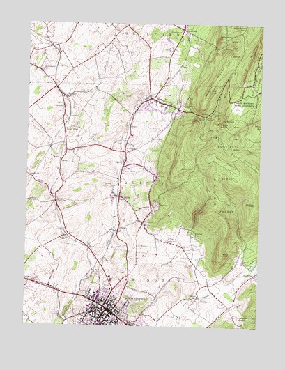
Waynesboro, PA USGS Topographic Map
Click on map above to begin viewing in our Map Viewer.

This topographic map contains these locations and features:
Feature Name Type Latitude Longitude GNIS ID View Map
AltenwaldPopulated PlaceN39.8451°W77.6036°1168225View Map
Antietam CoveValleyN39.7668°W77.5135°1168336View Map
Biesecker GapPopulated PlaceN39.7876°W77.5339°1169473View Map
Biesecker RunStreamN39.7623°W77.5328°1169474View Map
Blue Rock SchoolSchoolN39.7851°W77.5483°1169895View Map
Borough of Mont AltoCivilN39.8404°W77.5557°1215246View Map
Borough of WaynesboroCivilN39.7525°W77.5822°1215248View Map
Burns KnobSummitN39.7801°W77.5189°1170734View Map
Chestnut SpringSpringN39.8379°W77.5319°1171756View Map
Conboy SwitchLocaleN39.8309°W77.6042°1172278View Map
Curve MountainSummitN39.7965°W77.5211°1172860View Map
Deer Lick RunStreamN39.7729°W77.5039°1192340View Map
Eagle RockSummitN39.8337°W77.5205°1173695View Map
ElbrookPopulated PlaceN39.8179°W77.6067°1203501View Map
FairviewPopulated PlaceN39.7998°W77.5550°1174460View Map
Fairview SchoolSchoolN39.7559°W77.5900°1174540View Map
Five ForksPopulated PlaceN39.8015°W77.6086°1174860View Map
Forest SchoolSchoolN39.8415°W77.5408°1174982View Map
Fox HillPopulated PlaceN39.8123°W77.5544°1175094View Map
Fox Hill SchoolSchoolN39.8151°W77.5605°1175097View Map
Gap SchoolSchoolN39.7840°W77.5350°1175424View Map
Glen ForneyPopulated PlaceN39.7715°W77.5019°1192522View Map
GreendalePopulated PlaceN39.8023°W77.6222°1212853View Map
Greendale SchoolSchoolN39.8118°W77.6228°1176146View Map
Grindstone HillSummitN39.8562°W77.6169°1176247View Map
Grove Hill SchoolSchoolN39.7862°W77.6058°1176277View Map
Guilford SidingPopulated PlaceN39.8654°W77.6125°1203732View Map
JugtownPopulated PlaceN39.8418°W77.6050°1178187View Map
KnepperPopulated PlaceN39.8326°W77.5705°1203955View Map
LedyPopulated PlaceN39.8579°W77.5428°1204000View Map
Meeting of the Pines Natural AreaAreaN39.8473°W77.5225°1212850View Map
Mont AltoPopulated PlaceN39.8443°W77.5583°1181442View Map
Mont Alto Ambulance SquadBuildingN39.8389°W77.5665°2719474View Map
Mont Alto Post OfficePost OfficeN39.8447°W77.5592°2780017View Map
Mont Alto State ForestForestN39.8081°W77.5169°1192955View Map
Mont Alto State ParkParkN39.8370°W77.5314°1181443View Map
Mont Alto Volunteer Fire Department - Company 5BuildingN39.8399°W77.5657°2645271View Map
Montalto MountainSummitN39.8523°W77.5244°1192956View Map
NicodemusPopulated PlaceN39.7884°W77.6017°1204291View Map
NunneryPopulated PlaceN39.7901°W77.5786°1212852View Map
Oak Hill SchoolSchoolN39.8015°W77.6228°1182778View Map
Oak KnobSummitN39.8345°W77.5353°1182780View Map
Pearl SpringSpringN39.8368°W77.5283°1183427View Map
Pennsylvania State University - Mount Alto CampusSchoolN39.8420°W77.5417°1211473View Map
Pigeon Hills SchoolSchoolN39.8243°W77.5958°1183716View Map
Pine KnobSummitN39.8479°W77.5269°1183849View Map
Pivot RockSummitN39.8637°W77.5044°1201818View Map
Polk Hill SchoolSchoolN39.8234°W77.5667°1184208View Map
Pond BankPopulated PlaceN39.8729°W77.5414°1184227View Map
QuincyPopulated PlaceN39.8034°W77.5744°1184560View Map
Quincy High SchoolSchoolN39.8140°W77.5730°1184561View Map
Quincy MountainSummitN39.8156°W77.5422°1184563View Map
Quincy Post OfficePost OfficeN39.8037°W77.5754°2773243View Map
QuinsoniaPopulated PlaceN39.8365°W77.6022°1204457View Map
Red RunStreamN39.8365°W77.5292°1184781View Map
RoadsidePopulated PlaceN39.7634°W77.5317°1185160View Map
Rocky MountainSummitN39.8606°W77.5067°1185356View Map
Round TopSummitN39.8084°W77.5828°1185539View Map
Ryder SchoolSchoolN39.8409°W77.6055°1185668View Map
Sandy RidgeRidgeN39.8184°W77.5194°1193289View Map
Sandy Ridge TrailTrailN39.8118°W77.5042°1206256View Map
Shriners KnobSummitN39.8012°W77.5019°1187622View Map
SlabtownPopulated PlaceN39.8276°W77.5569°1187775View Map
Snowy Mountain VistaLocaleN39.8343°W77.5064°1206260View Map
State Game RefugeParkN39.8718°W77.5047°1211034View Map
Tarburner SpringSpringN39.8301°W77.5150°1189277View Map
The NarrowsGapN39.8351°W77.5192°1189430View Map
TomstownPopulated PlaceN39.7929°W77.5617°1189653View Map
Township of QuincyCivilN39.8148°W77.5493°1216469View Map
Travelers SpringSpringN39.8379°W77.5250°1189729View Map
Valley View VistaLocaleN39.8184°W77.5453°1206259View Map
Vineyard RunStreamN39.7743°W77.5036°1190434View Map
Warrior TrailTrailN39.8037°W77.5047°1206258View Map
WaynesboroPopulated PlaceN39.7559°W77.5778°1214022View Map
Waynesboro Ambulance SquadBuildingN39.7614°W77.5898°2719475View Map
Waynesboro Area Advanced Life Support Unit Medic 2BuildingN39.7513°W77.5706°2719476View Map
Waynesboro Country ClubLocaleN39.7609°W77.5300°1213397View Map
Waynesboro Fire Department Company 2 - Station 1 HeadquartersBuildingN39.7560°W77.5806°2645326View Map
Waynesboro Fire Department Company 2 - Station 2BuildingN39.7514°W77.5715°2645166View Map
Waynesboro HospitalHospitalN39.7517°W77.5683°2718085View Map
Waynesboro Hospital HeliportAirportN39.7504°W77.5708°1213704View Map
Waynesboro Police DepartmentBuildingN39.7550°W77.5760°2776970View Map
Waynesboro Post OfficePost OfficeN39.7539°W77.5751°2779795View Map
Waynesboro ReservoirReservoirN39.7545°W77.5047°1193617View Map
White Rock SchoolSchoolN39.8718°W77.5428°1191313View Map
White RocksPopulated PlaceN39.8698°W77.5217°1204945View Map
Zullinger Post OfficePost OfficeN39.7677°W77.6218°2780072View Map

Note: Coordinates in the location and feature list above are referenced to NAD83 datum.


Copyright (C) 2008-2024 Ryan Niemi / Sunset Dynamics ... All Rights Reserved