TopoQuest Logo
Do you find TopoQuest useful?
Help keep TopoQuest running and adding new maps/features by donating!
Bitcoin:  19c7KJd3qBynnjoSw5npx9KScwjBe4ifkT
Litecoin:  LXs6TkuXGGXo1vDsWCkWVdjQX94eUKd6ui
Home View Maps Find Maps Find Places Resources & Links


Greenwood, Texas Topographic Map

USGS Map Title: Greenwood, TX
USGS Map MRC: 33097D4
DRG (GeoTIFF) Download: o33097d4.tif


Neighboring USGS Topographic Map Quads:


  Forestburg, TX  
33097E5
 

  Freemound, TX  
33097E4
 

  Hood, TX  
33097E3
 

  New Harp, TX  
33097D5
 

  Greenwood, TX  
33097D4
 

  Era, TX  
33097D3
 

  Pecan Creek, TX  
33097C5
 

  Slidell, TX  
33097C4
 

  Era SE, TX  
33097C3


Map MRC Location:

N34°
W98°
N34°
W97°
H8 H7 H6 H5 H4 H3 H2 H1
G8 G7 G6 G5 G4 G3 G2 G1
F8 F7 F6 F5 F4 F3 F2 F1
E8 E7 E6 E5 E4 E3 E2 E1
D8 D7 D6 D5 D4 D3 D2 D1
C8 C7 C6 C5 C4 C3 C2 C1
B8 B7 B6 B5 B4 B3 B2 B1
A8 A7 A6 A5 A4 A3 A2 A1
N33°
W98°
N33°
W97°

Greenwood, TX USGS 1:24K Topographic Map Preview:
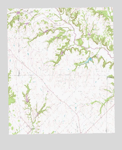
Greenwood, TX USGS Topographic Map
Click on map above to begin viewing in our Map Viewer.

This topographic map contains these locations and features:
Feature Name Type Latitude Longitude GNIS ID View Map
Bewley CemeteryCemeteryN33.4946°W97.4509°1381413View Map
Coons CreekStreamN33.4782°W97.4264°1381693View Map
Cove HollowValleyN33.4626°W97.4251°1383232View Map
Cove Hollow CreekStreamN33.4637°W97.4197°1381922View Map
Dixon CreekStreamN33.4593°W97.3911°1381769View Map
Dixon Creek ChurchChurchN33.4512°W97.3942°1381771View Map
Fannin CreekStreamN33.4779°W97.4214°1381861View Map
GreenwoodPopulated PlaceN33.3809°W97.4745°1381945View Map
Greenwood - Slidell Volunteer Fire Department Station 2BuildingN33.3805°W97.4734°2551737View Map
Greenwood Post OfficePost OfficeN33.3804°W97.4740°2731682View Map
LeoPopulated PlaceN33.4529°W97.3947°1382138View Map
Miller CreekStreamN33.3857°W97.4720°1382305View Map
Prairie PointPopulated PlaceN33.4954°W97.4745°1382568View Map
RosstonPopulated PlaceN33.4834°W97.4422°1382657View Map
Rosston Post OfficePost OfficeN33.4831°W97.4447°2731827View Map
Rosston Volunteer Fire DepartmentBuildingN33.4831°W97.4418°2551752View Map
Soil Conservation Service Site 17 DamDamN33.4068°W97.4770°1857272View Map
Soil Conservation Service Site 17 ReservoirReservoirN33.4068°W97.4770°1857273View Map
Soil Conservation Service Site 17a DamDamN33.3951°W97.4653°1857274View Map
Soil Conservation Service Site 17a ReservoirReservoirN33.3951°W97.4653°1857275View Map
Soil Conservation Service Site 21 DamDamN33.4718°W97.4020°1855268View Map
Soil Conservation Service Site 21 ReservoirReservoirN33.4718°W97.4020°1855269View Map
Soil Conservation Service Site 31 DamDamN33.4968°W97.4853°1855637View Map
Soil Conservation Service Site 31 ReservoirReservoirN33.4968°W97.4853°1855638View Map
Soil Conservation Service Site 32 DamDamN33.4851°W97.4753°1855260View Map
Soil Conservation Service Site 32 ReservoirReservoirN33.4851°W97.4753°1855261View Map
Soil Conservation Service Site 33 DamDamN33.4784°W97.4486°1855264View Map
Soil Conservation Service Site 33 ReservoirReservoirN33.4784°W97.4486°1855265View Map
Soil Conservation Service Site 34 DamDamN33.4718°W97.4370°1855258View Map
Soil Conservation Service Site 34 ReservoirReservoirN33.4718°W97.4370°1855259View Map
Soil Conservation Service Site 35 DamDamN33.4568°W97.4353°1855262View Map
Soil Conservation Service Site 35 ReservoirReservoirN33.4568°W97.4353°1855263View Map
Soil Conservation Service Site 36 DamDamN33.4501°W97.4003°1855266View Map
Soil Conservation Service Site 36 ReservoirReservoirN33.4501°W97.4003°1855267View Map
Tightwaad Air RanchAirportN33.4939°W97.4684°2676572View Map
Wheat CreekStreamN33.4862°W97.3761°1383213View Map
Williams CreekStreamN33.4959°W97.3797°1382972View Map

Note: Coordinates in the location and feature list above are referenced to NAD83 datum.


Copyright (C) 2008-2024 Ryan Niemi / Sunset Dynamics ... All Rights Reserved