TopoQuest Logo
Do you find TopoQuest useful?
Help keep TopoQuest running and adding new maps/features by donating!
Bitcoin:  19c7KJd3qBynnjoSw5npx9KScwjBe4ifkT
Litecoin:  LXs6TkuXGGXo1vDsWCkWVdjQX94eUKd6ui
Home View Maps Find Maps Find Places Resources & Links


Slidell, Texas Topographic Map

USGS Map Title: Slidell, TX
USGS Map MRC: 33097C4
DRG (GeoTIFF) Download: o33097c4.tif


Neighboring USGS Topographic Map Quads:


  New Harp, TX  
33097D5
 

  Greenwood, TX  
33097D4
 

  Era, TX  
33097D3
 

  Pecan Creek, TX  
33097C5
 

  Slidell, TX  
33097C4
 

  Era SE, TX  
33097C3
 

  Decatur, TX  
33097B5
 

  Bluett, TX  
33097B4
 

  Ponder, TX  
33097B3


Map MRC Location:

N34°
W98°
N34°
W97°
H8 H7 H6 H5 H4 H3 H2 H1
G8 G7 G6 G5 G4 G3 G2 G1
F8 F7 F6 F5 F4 F3 F2 F1
E8 E7 E6 E5 E4 E3 E2 E1
D8 D7 D6 D5 D4 D3 D2 D1
C8 C7 C6 C5 C4 C3 C2 C1
B8 B7 B6 B5 B4 B3 B2 B1
A8 A7 A6 A5 A4 A3 A2 A1
N33°
W98°
N33°
W97°

Slidell, TX USGS 1:24K Topographic Map Preview:
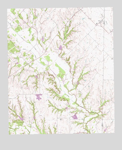
Slidell, TX USGS Topographic Map
Click on map above to begin viewing in our Map Viewer.

This topographic map contains these locations and features:
Feature Name Type Latitude Longitude GNIS ID View Map
AllisonPopulated PlaceN33.2665°W97.4267°1379334View Map
Bishop AirportAirportN33.2665°W97.4517°1386523View Map
Black CreekStreamN33.2798°W97.4211°1383532View Map
Black CreekStreamN33.2801°W97.4209°1352311View Map
Cain AirportAirportN33.3565°W97.4385°2675924View Map
Cowpatch Airport (historical)AirportN33.2951°W97.4456°1386525View Map
Eagle's LandingAirportN33.3058°W97.3804°1387030View Map
Greenwood - Slidell Volunteer Fire Department Station 3BuildingN33.3600°W97.3908°2551694View Map
Greenwood CemeteryCemeteryN33.3671°W97.4647°1358409View Map
Harts CreekStreamN33.3409°W97.4747°1358881View Map
Harts CreekStreamN33.3279°W97.4620°1383525View Map
JBJ Ranch AirportAirportN33.3085°W97.4536°2676608View Map
Lazy G Bar Ranch AirportAirportN33.2821°W97.4970°1386521View Map
North Pecan CreekStreamN33.3001°W97.4356°1383529View Map
North Pecan CreekStreamN33.3007°W97.4350°1364109View Map
Sisal CreekStreamN33.3562°W97.4942°1376134View Map
Sisal CreekStreamN33.3557°W97.4947°1383533View Map
SlidellPopulated PlaceN33.3598°W97.3917°1368430View Map
Slidell Post OfficePost OfficeN33.3593°W97.3905°2731784View Map
Soil Conservation Service Site 18e DamDamN33.3218°W97.4886°1857250View Map
Soil Conservation Service Site 18e ReservoirReservoirN33.3218°W97.4886°1857251View Map
Soil Conservation Service Site 20 DamDamN33.3434°W97.4586°1857252View Map
Soil Conservation Service Site 20 ReservoirReservoirN33.3434°W97.4586°1857253View Map
Soil Conservation Service Site 20a DamDamN33.3068°W97.4653°1857254View Map
Soil Conservation Service Site 20a ReservoirReservoirN33.3068°W97.4653°1857255View Map
Soil Conservation Service Site 21 DamDamN33.3334°W97.4386°1857256View Map
Soil Conservation Service Site 21 ReservoirReservoirN33.3334°W97.4386°1857257View Map
Soil Conservation Service Site 21a DamDamN33.3118°W97.4220°1857258View Map
Soil Conservation Service Site 21a ReservoirReservoirN33.3118°W97.4220°1857259View Map
Soil Conservation Service Site 21b DamDamN33.3001°W97.4186°1857260View Map
Soil Conservation Service Site 21b ReservoirReservoirN33.3001°W97.4186°1857261View Map
Soil Conservation Service Site 21c DamDamN33.2768°W97.4303°1857262View Map
Soil Conservation Service Site 21c ReservoirReservoirN33.2768°W97.4303°1857263View Map
Soil Conservation Service Site 21d DamDamN33.2851°W97.4086°1857264View Map
Soil Conservation Service Site 21d ReservoirReservoirN33.2851°W97.4086°1857265View Map
Soil Conservation Service Site 23 DamDamN33.2651°W97.4836°1857266View Map
Soil Conservation Service Site 23 ReservoirReservoirN33.2651°W97.4836°1857267View Map
Soil Conservation Service Site 24a DamDamN33.2668°W97.4703°1857268View Map
Soil Conservation Service Site 24a ReservoirReservoirN33.2668°W97.4703°1857269View Map
Soil Conservation Service Site 25 DamDamN33.2735°W97.3936°1857270View Map
Soil Conservation Service Site 25 ReservoirReservoirN33.2735°W97.3936°1857271View Map
Soil Conservation Service Site 25b DamDamN33.2518°W97.3870°1855470View Map
Soil Conservation Service Site 25b ReservoirReservoirN33.2518°W97.3870°1855471View Map
SycamorePopulated PlaceN33.3237°W97.4900°1380635View Map

Note: Coordinates in the location and feature list above are referenced to NAD83 datum.


Copyright (C) 2008-2025 Ryan Niemi / Sunset Dynamics ... All Rights Reserved