TopoQuest Logo
Do you find TopoQuest useful?
Help keep TopoQuest running and adding new maps/features by donating!
Bitcoin:  19c7KJd3qBynnjoSw5npx9KScwjBe4ifkT
Litecoin:  LXs6TkuXGGXo1vDsWCkWVdjQX94eUKd6ui
Home View Maps Find Maps Find Places Resources & Links


Grovespring, Missouri Topographic Map

USGS Map Title: Grovespring, MO
USGS Map MRC: 37092D5
DRG (GeoTIFF) Download: o37092d5.tif


Neighboring USGS Topographic Map Quads:


  Brush Creek, MO  
37092E6
 

  Russ, MO  
37092E5
 

  Drew, MO  
37092E4
 

  Rader, MO  
37092D6
 

  Grovespring, MO  
37092D5
 

  Competition, MO  
37092D4
 

  Duncan, MO  
37092C6
 

  Hartville, MO  
37092C5
 

  Fuson, MO  
37092C4


Map MRC Location:

N38°
W93°
N38°
W92°
H8 H7 H6 H5 H4 H3 H2 H1
G8 G7 G6 G5 G4 G3 G2 G1
F8 F7 F6 F5 F4 F3 F2 F1
E8 E7 E6 E5 E4 E3 E2 E1
D8 D7 D6 D5 D4 D3 D2 D1
C8 C7 C6 C5 C4 C3 C2 C1
B8 B7 B6 B5 B4 B3 B2 B1
A8 A7 A6 A5 A4 A3 A2 A1
N37°
W93°
N37°
W92°

Grovespring, MO USGS 1:24K Topographic Map Preview:
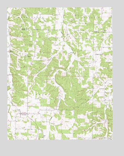
Grovespring, MO USGS Topographic Map
Click on map above to begin viewing in our Map Viewer.

This topographic map contains these locations and features:
Feature Name Type Latitude Longitude GNIS ID View Map
Bramhall CemeteryCemeteryN37.4367°W92.6235°714631View Map
Buttrom HollowValleyN37.4092°W92.6235°715140View Map
Cuba ChurchChurchN37.4648°W92.5946°716578View Map
Davis CemeteryCemeteryN37.4217°W92.6191°716709View Map
Davis CemeteryCemeteryN37.4723°W92.5541°716711View Map
Dinah HollowValleyN37.4642°W92.5582°716909View Map
DurbinPopulated PlaceN37.3759°W92.5016°740819View Map
Durbin ChurchChurchN37.3750°W92.5024°735035View Map
Durbin SchoolSchoolN37.3756°W92.5054°735034View Map
Fairview ChurchChurchN37.4889°W92.5443°717779View Map
GrovespringPopulated PlaceN37.3998°W92.6096°718906View Map
Grovespring Area Voluntary Fire Protection Association Station 1BuildingN37.4041°W92.6024°2621404View Map
Grovespring Post OfficePost OfficeN37.4001°W92.6087°2782756View Map
Hall SchoolSchoolN37.4539°W92.5968°719008View Map
Hall SchoolSchoolN37.4578°W92.6218°719011View Map
Mount Olive SchoolSchoolN37.4231°W92.5107°722828View Map
OrigannaPopulated PlaceN37.4784°W92.5116°741125View Map
Pleasant View ChurchChurchN37.4556°W92.5202°724646View Map
Rocky HollowValleyN37.4275°W92.6204°725516View Map
Shady ChurchChurchN37.3778°W92.5829°726230View Map
SmittlePopulated PlaceN37.4192°W92.5099°735033View Map
Smittle SchoolSchoolN37.4573°W92.5460°726643View Map
Township of UnionCivilN37.4144°W92.6062°767554View Map
Winters SchoolSchoolN37.4137°W92.5874°729014View Map

Note: Coordinates in the location and feature list above are referenced to NAD83 datum.


Copyright (C) 2008-2024 Ryan Niemi / Sunset Dynamics ... All Rights Reserved