TopoQuest Logo
Do you find TopoQuest useful?
Help keep TopoQuest running and adding new maps/features by donating!
Bitcoin:  19c7KJd3qBynnjoSw5npx9KScwjBe4ifkT
Litecoin:  LXs6TkuXGGXo1vDsWCkWVdjQX94eUKd6ui
Home View Maps Find Maps Find Places Resources & Links


Hartville, Missouri Topographic Map

USGS Map Title: Hartville, MO
USGS Map MRC: 37092C5
DRG (GeoTIFF) Download: o37092c5.tif


Neighboring USGS Topographic Map Quads:


  Rader, MO  
37092D6
 

  Grovespring, MO  
37092D5
 

  Competition, MO  
37092D4
 

  Duncan, MO  
37092C6
 

  Hartville, MO  
37092C5
 

  Fuson, MO  
37092C4
 

  Mansfield NW, MO  
37092B6
 

  Mansfield NE, MO  
37092B5
 

  Owens, MO  
37092B4


Map MRC Location:

N38°
W93°
N38°
W92°
H8 H7 H6 H5 H4 H3 H2 H1
G8 G7 G6 G5 G4 G3 G2 G1
F8 F7 F6 F5 F4 F3 F2 F1
E8 E7 E6 E5 E4 E3 E2 E1
D8 D7 D6 D5 D4 D3 D2 D1
C8 C7 C6 C5 C4 C3 C2 C1
B8 B7 B6 B5 B4 B3 B2 B1
A8 A7 A6 A5 A4 A3 A2 A1
N37°
W93°
N37°
W92°

Hartville, MO USGS 1:24K Topographic Map Preview:
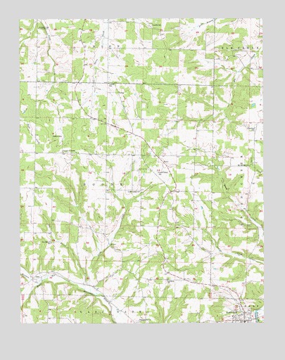
Hartville, MO USGS Topographic Map
Click on map above to begin viewing in our Map Viewer.

This topographic map contains these locations and features:
Feature Name Type Latitude Longitude GNIS ID View Map
Bowman CreekStreamN37.2675°W92.6141°714588View Map
BoyerPopulated PlaceN37.3162°W92.5516°740688View Map
Church of ChristChurchN37.3203°W92.6027°715833View Map
City of HartvilleCivilN37.2502°W92.5120°2394313View Map
City of Hartville Police DepartmentBuildingN37.2512°W92.5097°2752289View Map
Crawford SchoolSchoolN37.3300°W92.5043°716476View Map
Dry BranchStreamN37.2642°W92.5929°717065View Map
Dry Branch SchoolSchoolN37.2831°W92.6091°717081View Map
Grovespring Area Voluntary Fire Protection Association Station 2BuildingN37.3486°W92.5949°2621307View Map
HartvillePopulated PlaceN37.2509°W92.5104°719185View Map
Hartville Post OfficePost OfficeN37.2503°W92.5111°2783056View Map
Kindrick SchoolLocaleN37.3712°W92.6152°720601View Map
Krause CemeteryCemeteryN37.2903°W92.5088°720694View Map
Little CreekStreamN37.2627°W92.5890°721197View Map
Little Creek CemeteryCemeteryN37.3125°W92.5646°721211View Map
Little Creek ChurchChurchN37.3039°W92.5635°721212View Map
Little Creek SchoolSchoolN37.3120°W92.5541°721213View Map
LoringPopulated PlaceN37.3448°W92.5746°741027View Map
Loring SchoolSchoolN37.3484°W92.5793°721574View Map
Luallin SchoolSchoolN37.3723°W92.5568°721653View Map
Mount Moriah ChurchChurchN37.3145°W92.5074°722786View Map
Number Three School (historical)SchoolN37.2781°W92.5554°735045View Map
OdinPopulated PlaceN37.2684°W92.6185°723700View Map
Pleasant Hill ChurchChurchN37.2509°W92.5643°724526View Map
Pleasant Hill School (historical)SchoolN37.2503°W92.5632°735046View Map
Rogers SchoolSchoolN37.3267°W92.6035°725536View Map
Sunshine ChurchChurchN37.2675°W92.5496°727337View Map
Township of BooneCivilN37.3054°W92.6090°767545View Map
Wright County Sheriff's OfficeBuildingN37.2505°W92.5110°2752137View Map

Note: Coordinates in the location and feature list above are referenced to NAD83 datum.


Copyright (C) 2008-2025 Ryan Niemi / Sunset Dynamics ... All Rights Reserved