TopoQuest Logo
Do you find TopoQuest useful?
Help keep TopoQuest running and adding new maps/features by donating!
Bitcoin:  19c7KJd3qBynnjoSw5npx9KScwjBe4ifkT
Litecoin:  LXs6TkuXGGXo1vDsWCkWVdjQX94eUKd6ui
Home View Maps Find Maps Find Places Resources & Links


Guilford, North Carolina Topographic Map

USGS Map Title: Guilford, NC
USGS Map MRC: 36079A8
DRG (GeoTIFF) Download: o36079a8.tif


Neighboring USGS Topographic Map Quads:


  Belews Creek, NC  
36080B1
 

  Summerfield, NC  
36079B8
 

  Lake Brandt, NC  
36079B7
 

  Kernersville, NC  
36080A1
 

  Guilford, NC  
36079A8
 

  Greensboro, NC  
36079A7
 

  High Point West, NC  
35080H1
 

  High Point East, NC  
35079H8
 

  Pleasant Garden, NC  
35079H7


Map MRC Location:

N37°
W80°
N37°
W79°
H8 H7 H6 H5 H4 H3 H2 H1
G8 G7 G6 G5 G4 G3 G2 G1
F8 F7 F6 F5 F4 F3 F2 F1
E8 E7 E6 E5 E4 E3 E2 E1
D8 D7 D6 D5 D4 D3 D2 D1
C8 C7 C6 C5 C4 C3 C2 C1
B8 B7 B6 B5 B4 B3 B2 B1
A8 A7 A6 A5 A4 A3 A2 A1
N36°
W80°
N36°
W79°

Guilford, NC USGS 1:24K Topographic Map Preview:
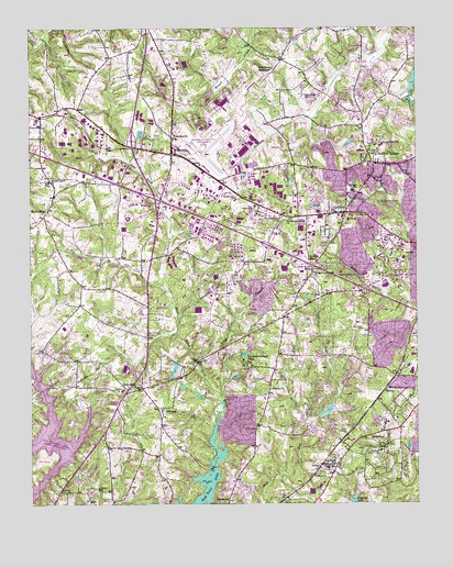
Guilford, NC USGS Topographic Map
Click on map above to begin viewing in our Map Viewer.

This topographic map contains these locations and features:
Feature Name Type Latitude Longitude GNIS ID View Map
Adams FarmPopulated PlaceN36.0271°W79.9078°1005015View Map
Adams LakeReservoirN36.0247°W79.9037°999925View Map
Adams Lake DamDamN36.0235°W79.9064°999924View Map
BeechcroftPopulated PlaceN36.0443°W79.8864°1005018View Map
Daniel Lumber Company LakeReservoirN36.0509°W79.8871°999988View Map
Daniel Lumber Company Lake DamDamN36.0518°W79.8864°999987View Map
Deep RiverPopulated PlaceN36.0304°W79.9684°984090View Map
Dogwood LakeReservoirN36.0015°W79.8954°984260View Map
Dogwood Lake DamDamN36.0004°W79.8950°999881View Map
East Fork Deep RiverStreamN36.0204°W79.9400°984500View Map
Fairfield LakeReservoirN36.0328°W79.8971°999936View Map
Fairfield Lake DamDamN36.0318°W79.8981°999937View Map
FlorencePopulated PlaceN36.0254°W79.9589°985230View Map
Florence Elementary SchoolSchoolN36.0246°W79.9570°1006625View Map
Freemon LakeReservoirN36.0135°W79.8781°999905View Map
Freemon Lake DamDamN36.0135°W79.8781°999906View Map
Friendly LakeReservoirN36.1131°W79.8895°1000102View Map
Friendly Lake DamDamN36.1151°W79.8898°1000103View Map
FriendshipPopulated PlaceN36.0921°W79.9539°1020366View Map
Friendship ChurchChurchN36.0965°W79.9536°985454View Map
FriendswoodPopulated PlaceN36.0701°W79.8961°1005019View Map
Greensboro Fire Department Station 18BuildingN36.0990°W79.8923°2639737View Map
Greensboro Fire Department Station 19BuildingN36.0823°W79.9274°2639736View Map
Greensboro Fire Department Station 20BuildingN36.0936°W79.9609°2639735View Map
Greensboro Fire Department Station 52BuildingN36.0603°W79.8867°2639756View Map
Greensboro Police Department - Division 3BuildingN36.0694°W79.9110°2769943View Map
GuilfordPopulated PlaceN36.0768°W79.8981°986191View Map
Guilford CollegePopulated PlaceN36.0918°W79.8873°1020574View Map
Guilford CollegeSchoolN36.0935°W79.8886°986192View Map
Guilford County Emergency ServicesBuildingN36.0600°W79.8870°2639719View Map
Guilford Memorial Park CemeteryCemeteryN36.0107°W79.9031°986194View Map
Guilford Middle SchoolSchoolN36.0821°W79.8953°1024830View Map
Guilford Post OfficePost OfficeN36.0772°W79.8949°2774202View Map
Guilford Primary SchoolSchoolN36.0737°W79.9120°1006623View Map
Hiatt BranchStreamN36.0165°W79.9939°986678View Map
High Point Fire Department Station 10BuildingN36.0311°W79.9713°2639665View Map
High Point Fire Department Station 11BuildingN36.0407°W79.9400°2639664View Map
High Point Fire Department Station 12BuildingN36.0557°W79.9829°2639667View Map
Hillside LakeReservoirN36.1235°W79.9231°1000124View Map
Hillside Lake DamDamN36.1235°W79.9231°1000125View Map
HilltopPopulated PlaceN36.0307°W79.8845°1020780View Map
Jefferson GardensPopulated PlaceN36.0999°W79.8789°1005022View Map
Long BranchStreamN36.0279°W79.9384°988911View Map
Madison WoodsPopulated PlaceN36.0846°W79.8825°1005020View Map
Midway ChurchChurchN36.0304°W79.9220°989830View Map
New Salem TabernacleChurchN36.1146°W79.9214°991098View Map
Oak Hollow DamDamN36.0118°W79.9864°999902View Map
Oak Hollow LakeReservoirN36.0118°W79.9864°999901View Map
Oak Hollow LakeLakeN36.0183°W79.9960°1000994View Map
Oaks WestPopulated PlaceN36.0382°W79.8864°1005017View Map
Persimmon Grove ChurchChurchN36.0749°W79.9159°992065View Map
Piedmont Triad Airport Authority Fire Rescue DepartmentBuildingN36.0929°W79.9507°2639837View Map
Piedmont Triad International AirportAirportN36.1061°W79.9370°998027View Map
Pilot Life DamDamN36.0201°W79.8864°999915View Map
Pinecroft - Sedgefield Fire Station 23BuildingN36.0171°W79.9011°2639733View Map
Ponoma QuarryMineN36.0525°W79.9278°2649269View Map
Quaker AcresPopulated PlaceN36.0951°W79.9056°1005021View Map
Raleigh Crossroads ChurchChurchN36.0604°W79.9081°993001View Map
Reynolds ChapelChurchN36.0637°W79.9073°993254View Map
Sandy RidgePopulated PlaceN36.0760°W79.9953°994313View Map
SedgefieldPopulated PlaceN36.0149°W79.8970°1022535View Map
Sedgefield Country ClubLocaleN36.0137°W79.8870°994481View Map
Sedgefield LakesPopulated PlaceN36.0340°W79.8981°1005016View Map
Smiths Grove ChurchChurchN36.0851°W79.9934°995007View Map
Southwest Elementary SchoolSchoolN36.0512°W79.9834°1006615View Map
Southwest High SchoolSchoolN36.0418°W79.9937°1006614View Map
Township of FriendshipCivilN36.0446°W79.9341°1026735View Map
Upper Colonial DamDamN36.1035°W79.9348°1000074View Map
Upper Colonial LakeReservoirN36.1035°W79.9348°1000075View Map
Uwharrie Council CampLocaleN36.0357°W79.9292°996567View Map
Uwharrie LakeReservoirN36.0418°W79.9284°999958View Map
Uwharrie Lake DamDamN36.0401°W79.9281°999957View Map
Western Guilford High SchoolSchoolN36.0824°W79.9081°1006624View Map
WQFS-FM (Greensboro)TowerN36.0943°W79.8889°1018333View Map

Note: Coordinates in the location and feature list above are referenced to NAD83 datum.


Copyright (C) 2008-2025 Ryan Niemi / Sunset Dynamics ... All Rights Reserved