TopoQuest Logo
Do you find TopoQuest useful?
Help keep TopoQuest running and adding new maps/features by donating!
Bitcoin:  19c7KJd3qBynnjoSw5npx9KScwjBe4ifkT
Litecoin:  LXs6TkuXGGXo1vDsWCkWVdjQX94eUKd6ui
Home View Maps Find Maps Find Places Resources & Links


Pleasant Garden, North Carolina Topographic Map

USGS Map Title: Pleasant Garden, NC
USGS Map MRC: 35079H7
DRG (GeoTIFF) Download: o35079h7.tif


Neighboring USGS Topographic Map Quads:


  Guilford, NC  
36079A8
 

  Greensboro, NC  
36079A7
 

  McLeansville, NC  
36079A6
 

  High Point East, NC  
35079H8
 

  Pleasant Garden, NC  
35079H7
 

  Climax, NC  
35079H6
 

  Glenola, NC  
35079G8
 

  Randleman, NC  
35079G7
 

  Grays Chapel, NC  
35079G6


Map MRC Location:

N36°
W80°
N36°
W79°
H8 H7 H6 H5 H4 H3 H2 H1
G8 G7 G6 G5 G4 G3 G2 G1
F8 F7 F6 F5 F4 F3 F2 F1
E8 E7 E6 E5 E4 E3 E2 E1
D8 D7 D6 D5 D4 D3 D2 D1
C8 C7 C6 C5 C4 C3 C2 C1
B8 B7 B6 B5 B4 B3 B2 B1
A8 A7 A6 A5 A4 A3 A2 A1
N35°
W80°
N35°
W79°

Pleasant Garden, NC USGS 1:24K Topographic Map Preview:
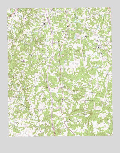
Pleasant Garden, NC USGS Topographic Map
Click on map above to begin viewing in our Map Viewer.

This topographic map contains these locations and features:
Feature Name Type Latitude Longitude GNIS ID View Map
Benbow LakeReservoirN35.9862°W79.7892°999849View Map
Benbow Lake DamDamN35.9851°W79.7898°999848View Map
Bullock SchoolSchoolN35.9718°W79.7814°982237View Map
Burnetts ChapelChurchN35.9454°W79.8273°982285View Map
Camp Douglas LongLocaleN35.9649°W79.8545°982529View Map
Cedar Square ChurchChurchN35.8868°W79.8689°982903View Map
Centre ChurchChurchN35.9215°W79.8020°982976View Map
Coltranes MillPopulated PlaceN35.9060°W79.8564°1019746View Map
Community ChurchChurchN35.9543°W79.8481°983416View Map
Concord ChurchChurchN35.9829°W79.8328°983436View Map
Fields AirportAirportN35.8985°W79.7722°2679291View Map
Galilee ChurchChurchN35.8890°W79.8650°985527View Map
Good Hope ChurchChurchN35.9232°W79.8095°985787View Map
Green Valley FarmLocaleN35.8989°W79.8353°2633196View Map
Groome Sand Rock PitMineN35.9981°W79.8508°2649041View Map
GroometownPopulated PlaceN35.9912°W79.8675°1020569View Map
Guil - Rand Fire Department Station 41BuildingN35.8882°W79.8709°2639313View Map
Hickory CreekStreamN35.9276°W79.8689°986694View Map
Hunt LakeReservoirN35.9424°W79.7678°999762View Map
Hunt Lake DamDamN35.9418°W79.7681°999763View Map
Lakeview ChurchChurchN35.9985°W79.7934°988098View Map
Level CrossPopulated PlaceN35.8890°W79.8078°988368View Map
Level Cross Voluntary Fire DepartmentBuildingN35.8893°W79.8066°2639345View Map
Pinecroft - Sedgefield Fire Station 24BuildingN35.9929°W79.8615°2638157View Map
Pinecroft - Sedgefield Fire Station 25BuildingN35.9435°W79.8306°2639654View Map
Pleasant GardenPopulated PlaceN35.9621°W79.7623°1021999View Map
Pleasant Garden Elementary SchoolSchoolN35.9612°W79.7617°1006600View Map
Pleasant Garden Fire DepartmentBuildingN35.9634°W79.7626°2638427View Map
Pleasant Garden Post OfficePost OfficeN35.9689°W79.7642°2774166View Map
Reddicks CreekStreamN35.9357°W79.8709°993141View Map
Rehobeth ChurchChurchN35.9987°W79.8209°993234View Map
Ritters LakeReservoirN35.9901°W79.7923°993371View Map
Southern Guilford High SchoolSchoolN35.9493°W79.8553°995234View Map
Sumner ChurchChurchN35.9971°W79.8123°995693View Map
Sumner SchoolSchoolN35.9851°W79.8306°995694View Map
Town of Pleasant GardenCivilN35.9595°W79.7598°2407133View Map
Township of Level CrossCivilN35.8825°W79.8054°1027083View Map
Township of SumnerCivilN35.9598°W79.8368°1026746View Map
White Rock ChurchChurchN35.9779°W79.8031°997208View Map
Wood LakeReservoirN35.9716°W79.7936°999826View Map
Wood Lake DamDamN35.9701°W79.7948°999827View Map
Yowland LakeReservoirN35.9922°W79.7601°999860View Map
Yowland Lake DamDamN35.9918°W79.7581°999861View Map

Note: Coordinates in the location and feature list above are referenced to NAD83 datum.


Copyright (C) 2008-2024 Ryan Niemi / Sunset Dynamics ... All Rights Reserved