TopoQuest Logo
Do you find TopoQuest useful?
Help keep TopoQuest running and adding new maps/features by donating!
Bitcoin:  19c7KJd3qBynnjoSw5npx9KScwjBe4ifkT
Litecoin:  LXs6TkuXGGXo1vDsWCkWVdjQX94eUKd6ui
Home View Maps Find Maps Find Places Resources & Links


Guinda, California Topographic Map

USGS Map Title: Guinda, CA
USGS Map MRC: 38122G2
DRG (GeoTIFF) Download: o38122g2.tif


Neighboring USGS Topographic Map Quads:


  Glascock Mountain, CA  
38122H3
 

  Rumsey, CA  
38122H2
 

  Wildwood School, CA  
38122H1
 

  Knoxville, CA  
38122G3
 

  Guinda, CA  
38122G2
 

  Bird Valley, CA  
38122G1
 

  Walter Springs, CA  
38122F3
 

  Brooks, CA  
38122F2
 

  Esparto, CA  
38122F1


Map MRC Location:

N39°
W123°
N39°
W122°
H8 H7 H6 H5 H4 H3 H2 H1
G8 G7 G6 G5 G4 G3 G2 G1
F8 F7 F6 F5 F4 F3 F2 F1
E8 E7 E6 E5 E4 E3 E2 E1
D8 D7 D6 D5 D4 D3 D2 D1
C8 C7 C6 C5 C4 C3 C2 C1
B8 B7 B6 B5 B4 B3 B2 B1
A8 A7 A6 A5 A4 A3 A2 A1
N38°
W123°
N38°
W122°

Guinda, CA USGS 1:24K Topographic Map Preview:
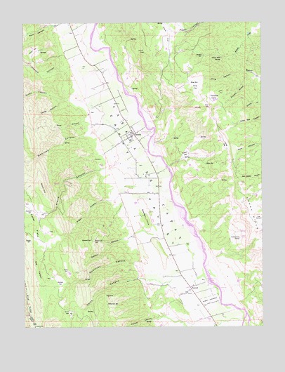
Guinda, CA USGS Topographic Map
Click on map above to begin viewing in our Map Viewer.

This topographic map contains these locations and features:
Feature Name Type Latitude Longitude GNIS ID View Map
Angus CanyonValleyN38.8041°W122.2011°218285View Map
Big CanyonValleyN38.7649°W122.2394°219144View Map
Big RockPillarN38.7621°W122.2072°219237View Map
Black MountainSummitN38.8071°W122.2419°219380View Map
Brooks CreekStreamN38.7530°W122.1364°1670272View Map
Butler SpringSpringN38.7852°W122.2475°220282View Map
Caņada De CapayCivilN38.8113°W122.1839°255075View Map
Caņon SchoolSchoolN38.7535°W122.1536°220551View Map
Capay Valley Fire Protection District Guinda StationBuildingN38.8301°W122.1933°2624557View Map
Capell CreekStreamN38.7643°W122.2094°220581View Map
Casey FlatsFlatN38.7921°W122.2444°254719View Map
Chase CanyonValleyN38.8430°W122.2322°220926View Map
China PeakSummitN38.8630°W122.1911°1658273View Map
Cobbey CanyonValleyN38.7880°W122.1933°221283View Map
Community Methodist ChurchChurchN38.8277°W122.1966°1657271View Map
Cottonwood SpringSpringN38.7860°W122.1380°221658View Map
Cross CanyonValleyN38.8430°W122.2225°221855View Map
Dubois SpringSpringN38.8616°W122.1566°253693View Map
Duncan SpringSpringN38.7980°W122.2469°222721View Map
Esparto DivisionCivilN38.7862°W122.1377°1935095View Map
Eureka GulchValleyN38.8535°W122.1297°223275View Map
Everett FlatFlatN38.8210°W122.1669°223291View Map
Fredericks SpringSpringN38.7863°W122.2144°223852View Map
Gibbs SpringSpringN38.8168°W122.1555°224149View Map
GuindaPopulated PlaceN38.8291°W122.1939°224711View Map
Guinda Census Designated PlaceCensusN38.8275°W122.1985°2628737View Map
Guinda Post OfficePost OfficeN38.8290°W122.1923°2789166View Map
Hamilton CanyonValleyN38.8291°W122.2125°224835View Map
Hamilton CreekStreamN38.8338°W122.1875°1670268View Map
Indian Mike SpringSpringN38.8605°W122.1469°254812View Map
Indian SchoolSchoolN38.8163°W122.2100°225899View Map
Johnson CanyonValleyN38.8568°W122.2269°234089View Map
Jones FlatFlatN38.8235°W122.1450°226335View Map
King CanyonValleyN38.8532°W122.1297°226584View Map
King FlatFlatN38.8471°W122.1614°226588View Map
King SpringSpringN38.8502°W122.1597°226597View Map
Lawson SpringSpringN38.7857°W122.2161°226969View Map
McKinney CanyonValleyN38.7735°W122.1897°228414View Map
Myers FlatFlatN38.8624°W122.2450°254965View Map
Pace FlatFlatN38.8696°W122.1755°230189View Map
Palmer CanyonValleyN38.7538°W122.1794°230264View Map
Paradise ValleyBasinN38.8430°W122.1528°230325View Map
Patterson SpringSpringN38.7588°W122.2078°230417View Map
Pierce CanyonValleyN38.8160°W122.2044°230635View Map
Reiff CanyonValleyN38.8741°W122.2347°231486View Map
Rose CanyonValleyN38.8332°W122.2161°231883View Map
Smith CanyonValleyN38.7693°W122.1880°233312View Map
Smith FlatFlatN38.7560°W122.2275°233331View Map
Sweitzer HillsRangeN38.7946°W122.1878°235899View Map
TancredPopulated PlaceN38.7652°W122.1636°1659956View Map
Vernon A Nichols County ParkParkN38.8291°W122.1833°1657272View Map
Winters FlatFlatN38.7682°W122.2325°238051View Map

Note: Coordinates in the location and feature list above are referenced to NAD83 datum.


Copyright (C) 2008-2025 Ryan Niemi / Sunset Dynamics ... All Rights Reserved