TopoQuest Logo
Do you find TopoQuest useful?
Help keep TopoQuest running and adding new maps/features by donating!
Bitcoin:  19c7KJd3qBynnjoSw5npx9KScwjBe4ifkT
Litecoin:  LXs6TkuXGGXo1vDsWCkWVdjQX94eUKd6ui
Home View Maps Find Maps Find Places Resources & Links


Gum Lake, Florida Topographic Map

USGS Map Title: Gum Lake, FL
USGS Map MRC: 28081B6
DRG (GeoTIFF) Download: o28081b6.tif


Neighboring USGS Topographic Map Quads:


  Poyner, FL  
28081C7
 

  Lake Louisa SW, FL  
28081C6
 

  Intercession City, FL  
28081C5
 

  Polk City, FL  
28081B7
 

  Gum Lake, FL  
28081B6
 

  Davenport, FL  
28081B5
 

  Auburndale, FL  
28081A7
 

  Winter Haven, FL  
28081A6
 

  Dundee, FL  
28081A5


Map MRC Location:

N29°
W82°
N29°
W81°
H8 H7 H6 H5 H4 H3 H2 H1
G8 G7 G6 G5 G4 G3 G2 G1
F8 F7 F6 F5 F4 F3 F2 F1
E8 E7 E6 E5 E4 E3 E2 E1
D8 D7 D6 D5 D4 D3 D2 D1
C8 C7 C6 C5 C4 C3 C2 C1
B8 B7 B6 B5 B4 B3 B2 B1
A8 A7 A6 A5 A4 A3 A2 A1
N28°
W82°
N28°
W81°

Gum Lake, FL USGS 1:24K Topographic Map Preview:
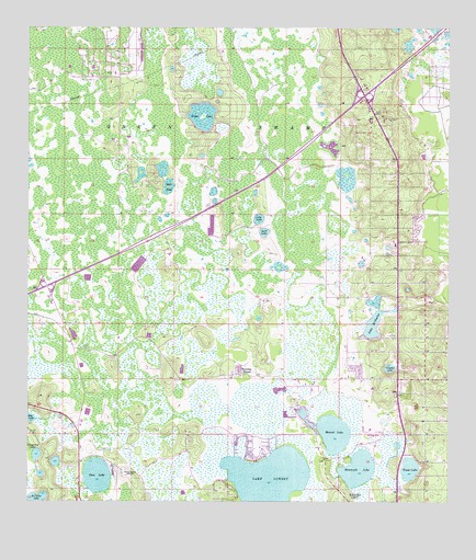
Gum Lake, FL USGS Topographic Map
Click on map above to begin viewing in our Map Viewer.

This topographic map contains these locations and features:
Feature Name Type Latitude Longitude GNIS ID View Map
Bay LakeLakeN28.1474°W81.7497°278214View Map
Blue Heron Bay Mobile Home ParkPopulated PlaceN28.1777°W81.6433°2449287View Map
Bonnet LakeLakeN28.1437°W81.6595°279214View Map
Clair Mar Mobile Home ParkPopulated PlaceN28.1737°W81.6423°2448530View Map
Crystal LakeLakeN28.1606°W81.6422°281122View Map
Davenport Fire TowerTowerN28.2436°W81.6526°301379View Map
Diamond Acres Mobile ParkPopulated PlaceN28.1577°W81.6493°2448524View Map
Duck PondLakeN28.2084°W81.7080°281819View Map
Emerald Lake Mobile Home ParkPopulated PlaceN28.1886°W81.6504°2448531View Map
Fort Cummings (historical)LocaleN28.1336°W81.6998°294546View Map
Glades Country ClubLocaleN28.1260°W81.6299°2449278View Map
Gore AirportAirportN28.1435°W81.6461°309476View Map
Grass LakeLakeN28.2247°W81.6985°283297View Map
Gum LakeLakeN28.1321°W81.7290°283538View Map
Haines City DivisionCivilN28.1513°W81.6327°1935790View Map
Hammock LakeLakeN28.1338°W81.6514°283654View Map
Heart of Florida Medical Center HeliportAirportN28.1814°W81.6428°2448521View Map
Heart of Florida Regional Medical CenterHospitalN28.1815°W81.6420°298616View Map
Holiday ManorPopulated PlaceN28.1592°W81.6862°284148View Map
Lake Hammock VillagePopulated PlaceN28.1261°W81.6435°2449285View Map
Lake LoweryLakeN28.1303°W81.6779°286180View Map
Lake Saint CharlesLakeN28.1717°W81.6478°290161View Map
Lost LakeLakeN28.1999°W81.6812°286108View Map
Oak Harbor Seaplane BaseAirportN28.1292°W81.6876°309475View Map
Polk County Sheriff's Office - Northeast DistrictBuildingN28.2452°W81.6519°2755982View Map
Saint Claire LakeLakeN28.1256°W81.7475°290165View Map
Sand LakeLakeN28.1964°W81.6796°290534View Map
Tangerine LakeLakeN28.1376°W81.7472°292017View Map
Tower LakeLakeN28.1339°W81.6362°292377View Map
Village of la Casa del Sol Mobile Home ParkPopulated PlaceN28.1738°W81.6423°2448528View Map
WGTO-AM (Cypress Gardens)TowerN28.1328°W81.7209°308655View Map
Windmill Village Mobile Home ParkPopulated PlaceN28.1416°W81.6338°2448529View Map
WLVF-FM (Haines City)TowerN28.1581°W81.6259°309001View Map

Note: Coordinates in the location and feature list above are referenced to NAD83 datum.


Copyright (C) 2008-2024 Ryan Niemi / Sunset Dynamics ... All Rights Reserved