TopoQuest Logo
Do you find TopoQuest useful?
Help keep TopoQuest running and adding new maps/features by donating!
Bitcoin:  19c7KJd3qBynnjoSw5npx9KScwjBe4ifkT
Litecoin:  LXs6TkuXGGXo1vDsWCkWVdjQX94eUKd6ui
Home View Maps Find Maps Find Places Resources & Links


Polk City, Florida Topographic Map

USGS Map Title: Polk City, FL
USGS Map MRC: 28081B7
DRG (GeoTIFF) Download: o28081b7.tif


Neighboring USGS Topographic Map Quads:


  Rock Ridge, FL  
28081C8
 

  Poyner, FL  
28081C7
 

  Lake Louisa SW, FL  
28081C6
 

  Providence, FL  
28081B8
 

  Polk City, FL  
28081B7
 

  Gum Lake, FL  
28081B6
 

  Lakeland, FL  
28081A8
 

  Auburndale, FL  
28081A7
 

  Winter Haven, FL  
28081A6


Map MRC Location:

N29°
W82°
N29°
W81°
H8 H7 H6 H5 H4 H3 H2 H1
G8 G7 G6 G5 G4 G3 G2 G1
F8 F7 F6 F5 F4 F3 F2 F1
E8 E7 E6 E5 E4 E3 E2 E1
D8 D7 D6 D5 D4 D3 D2 D1
C8 C7 C6 C5 C4 C3 C2 C1
B8 B7 B6 B5 B4 B3 B2 B1
A8 A7 A6 A5 A4 A3 A2 A1
N28°
W82°
N28°
W81°

Polk City, FL USGS 1:24K Topographic Map Preview:
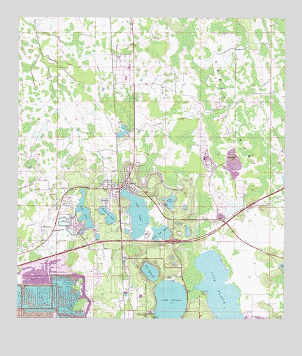
Polk City, FL USGS Topographic Map
Click on map above to begin viewing in our Map Viewer.

This topographic map contains these locations and features:
Feature Name Type Latitude Longitude GNIS ID View Map
Camp GileadLocaleN28.1728°W81.8067°279901View Map
Cherokee Ranch Airport (historical)AirportN28.2311°W81.8120°309835View Map
Clearwater LakeLakeN28.1682°W81.8327°280549View Map
Fantasy of FlightParkN28.1670°W81.8074°2564042View Map
Flanders FieldAirportN28.2075°W81.8280°309836View Map
Florida Polytechnic UniversitySchoolN28.1507°W81.8513°2771861View Map
Grant Estates Mobile Home ParkPopulated PlaceN28.1427°W81.8386°2451902View Map
Lake AgnesSwampN28.1687°W81.8188°277698View Map
Lake HeleneLakeN28.1739°W81.8033°283870View Map
Lake JulianaLakeN28.1277°W81.8029°284964View Map
Lake Juliana Landings Mobile Home EstatesPopulated PlaceN28.1427°W81.7996°2447632View Map
Lake MattieLakeN28.1378°W81.7803°286526View Map
Lake Mattie MarshSwampN28.1415°W81.7667°301380View Map
Lake Mattie Mobile Home ParkPopulated PlaceN28.1361°W81.7868°2447633View Map
Lake TennesseeLakeN28.1447°W81.8123°292124View Map
Little Lake AgnesLakeN28.1609°W81.8075°285723View Map
Marker Road Mobile Home ParkPopulated PlaceN28.1468°W81.8372°2451903View Map
Mount Olive ChurchChurchN28.1603°W81.8465°287254View Map
Mud LakeSwampN28.1692°W81.8434°287403View Map
Orlampa Inc AirportAirportN28.1668°W81.8076°309837View Map
Pok City Post OfficePost OfficeN28.1781°W81.8305°2768021View Map
Polk CityPopulated PlaceN28.1825°W81.8240°289150View Map
Polk City Community CenterBuildingN28.1805°W81.8241°2451901View Map
Polk City Elementary SchoolSchoolN28.1818°W81.8234°299309View Map
Polk Correctional InstitutionBuildingN28.1926°W81.7867°301381View Map
Polk County Fire Department Station 130 Polk CityBuildingN28.1812°W81.8249°2131418View Map
Polk County Rescue Station 131 Polk CityBuildingN28.1813°W81.8248°2661688View Map
Polk County Sheriff's Office SubstationBuildingN28.1827°W81.8227°2756096View Map
Town of Polk CityCivilN28.1804°W81.8296°2407139View Map

Note: Coordinates in the location and feature list above are referenced to NAD83 datum.


Copyright (C) 2008-2025 Ryan Niemi / Sunset Dynamics ... All Rights Reserved