TopoQuest Logo
Do you find TopoQuest useful?
Help keep TopoQuest running and adding new maps/features by donating!
Bitcoin:  19c7KJd3qBynnjoSw5npx9KScwjBe4ifkT
Litecoin:  LXs6TkuXGGXo1vDsWCkWVdjQX94eUKd6ui
Home View Maps Find Maps Find Places Resources & Links


Gunpowder Neck, Maryland Topographic Map

USGS Map Title: Gunpowder Neck, MD
USGS Map MRC: 39076C3
DRG (GeoTIFF) Download: o39076c3.tif


Neighboring USGS Topographic Map Quads:


  White Marsh, MD  
39076D4
 

  Edgewood, MD  
39076D3
 

  Perryman, MD  
39076D2
 

  Middle River, MD  
39076C4
 

  Gunpowder Neck, MD  
39076C3
 

  Hanesville, MD  
39076C2
 

  Sparrows Point, MD  
39076B4
 

  Swan Point, MD  
39076B3
 

  Rock Hall, MD  
39076B2


Map MRC Location:

N40°
W77°
N40°
W76°
H8 H7 H6 H5 H4 H3 H2 H1
G8 G7 G6 G5 G4 G3 G2 G1
F8 F7 F6 F5 F4 F3 F2 F1
E8 E7 E6 E5 E4 E3 E2 E1
D8 D7 D6 D5 D4 D3 D2 D1
C8 C7 C6 C5 C4 C3 C2 C1
B8 B7 B6 B5 B4 B3 B2 B1
A8 A7 A6 A5 A4 A3 A2 A1
N39°
W77°
N39°
W76°

Gunpowder Neck, MD USGS 1:24K Topographic Map Preview:
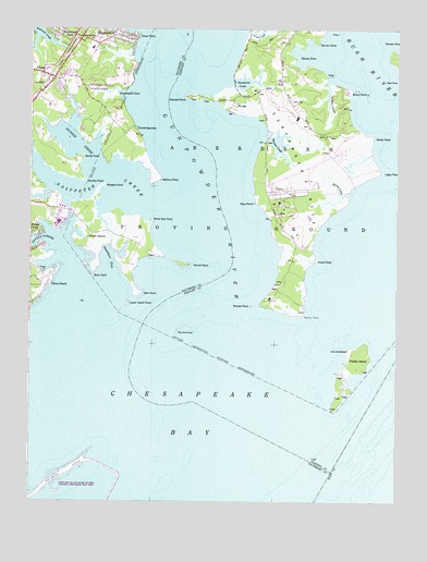
Gunpowder Neck, MD USGS Topographic Map
Click on map above to begin viewing in our Map Viewer.

This topographic map contains these locations and features:
Feature Name Type Latitude Longitude GNIS ID View Map
Baltimore County Fire Department Chase - Station 54BuildingN39.3592°W76.3710°2087033View Map
Barren PointCapeN39.3715°W76.2769°583041View Map
Battery PointCapeN39.3357°W76.3319°583056View Map
Bengies PointCapeN39.3337°W76.3497°583154View Map
Boone CreekStreamN39.3315°W76.2661°583325View Map
Brier PointCapeN39.3109°W76.3536°583388View Map
Briery PointCapeN39.3590°W76.2663°583391View Map
Bush PointCapeN39.3616°W76.2504°583503View Map
Carroll IslandIslandN39.3215°W76.3511°583603View Map
Carroll PointCapeN39.3126°W76.3216°583605View Map
ChasePopulated PlaceN39.3634°W76.3711°589943View Map
Chase Post OfficePost OfficeN39.3583°W76.3722°594094View Map
Chase StationLocaleN39.3609°W76.3700°583710View Map
Christian Fellowship ChurchChurchN39.3657°W76.3631°2503199View Map
Coopers CreekStreamN39.3609°W76.2738°583891View Map
Cunninghill CovePopulated PlaceN39.3654°W76.3608°594100View Map
Cunninghill CoveBayN39.3573°W76.3427°583995View Map
Days PointCapeN39.3293°W76.2977°584035View Map
Doves CoveBayN39.3687°W76.2805°588769View Map
Dundee CreekStreamN39.3371°W76.3516°584189View Map
Dundee Natural Environment AreaParkN39.3587°W76.3669°594104View Map
Ford PointCapeN39.3140°W76.2777°584438View Map
Goose Harbor MarinaLocaleN39.3113°W76.3665°2503322View Map
Grace Church of GodChurchN39.3696°W76.3600°2503325View Map
Graces QuartersLocaleN39.3493°W76.3391°584684View Map
Gunpowder NeckCapeN39.3332°W76.2811°584809View Map
Gunpowder RiverStreamN39.2979°W76.3302°584810View Map
Gunpowder State ParkParkN39.3626°W76.3425°588924View Map
HarewoodPopulated PlaceN39.3732°W76.3444°590415View Map
Harewood StationLocaleN39.3721°W76.3586°584866View Map
Hart-Miller IslandIslandN39.2518°W76.3733°588926View Map
Hart-Miller Pleasure Islands Natural Resources Management ParkParkN39.2512°W76.3608°594121View Map
Hawthorn CoveBayN39.3132°W76.3483°584905View Map
J and C Unity Christian ChurchChurchN39.3620°W76.3659°2503399View Map
Lego PointCapeN39.3368°W76.2555°588927View Map
Lower Island PointCapeN39.3037°W76.3402°585623View Map
Marshy PointCapeN39.3351°W76.3569°585712View Map
Marshy Point NurseryBuildingN39.3392°W76.3600°2651592View Map
Maxwell PointCapeN39.3573°W76.3205°585742View Map
Miami BeachPopulated PlaceN39.3071°W76.3700°590791View Map
Miami Beach ParkParkN39.3068°W76.3741°592235View Map
Oliver BeachPopulated PlaceN39.3729°W76.3427°594153View Map
Oliver Beach Elementary SchoolSchoolN39.3699°W76.3541°594154View Map
Oliver PointCapeN39.3737°W76.3380°586331View Map
Phillips Island (historical)IslandN39.3015°W76.3052°1698806View Map
Pooles IslandIslandN39.2854°W76.2652°586646View Map
Pooles Island LightLocaleN39.2904°W76.2663°2038054View Map
Porters Seneca Park MarinaLocaleN39.3209°W76.3725°2503581View Map
Rickett PointCapeN39.3021°W76.2983°586827View Map
Robins PointCapeN39.3004°W76.2822°588808View Map
Saltpeter CreekStreamN39.3301°W76.3338°587174View Map
Sandy PointCapeN39.3412°W76.3575°587209View Map
Sandy PointCapeN39.3471°W76.2586°587210View Map
Seneca CreekStreamN39.3129°W76.3611°587272View Map
Seneca ParkPopulated PlaceN39.3237°W76.3750°591247View Map
Spry Island (historical)IslandN39.2957°W76.3236°1698835View Map
Spry Island ShoalBarN39.2957°W76.3236°587518View Map
Swaderick CreekBayN39.3612°W76.3055°587640View Map
Tripcellar SwampSwampN39.3322°W76.2734°1698849View Map
Watson CreekStreamN39.3484°W76.2941°588083View Map
Weir PointCapeN39.3051°W76.3369°588105View Map
White Oak PointCapeN39.3234°W76.3347°588203View Map
Woods at Bay CountryPopulated PlaceN39.3684°W76.3700°594202View Map
Wright CreekStreamN39.3748°W76.3000°588351View Map

Note: Coordinates in the location and feature list above are referenced to NAD83 datum.


Copyright (C) 2008-2024 Ryan Niemi / Sunset Dynamics ... All Rights Reserved