TopoQuest Logo
Do you find TopoQuest useful?
Help keep TopoQuest running and adding new maps/features by donating!
Bitcoin:  19c7KJd3qBynnjoSw5npx9KScwjBe4ifkT
Litecoin:  LXs6TkuXGGXo1vDsWCkWVdjQX94eUKd6ui
Home View Maps Find Maps Find Places Resources & Links


Gypsum, Ohio Topographic Map

USGS Map Title: Gypsum, OH
USGS Map MRC: 41082E7
DRG (GeoTIFF) Download: o41082e7.tif


Neighboring USGS Topographic Map Quads:


  Put-in-Bay, OH  
41082F7


  Port Clinton, OH  
41082E8
 

  Gypsum, OH  
41082E7
 

  Kelleys Island, OH  
41082E6
 

  Vickery, OH  
41082D8
 

  Castalia, OH  
41082D7
 

  Sandusky, OH  
41082D6


Map MRC Location:

N42°
W83°
N42°
W82°
H8 H7 H6 H5 H4 H3 H2 H1
G8 G7 G6 G5 G4 G3 G2 G1
F8 F7 F6 F5 F4 F3 F2 F1
E8 E7 E6 E5 E4 E3 E2 E1
D8 D7 D6 D5 D4 D3 D2 D1
C8 C7 C6 C5 C4 C3 C2 C1
B8 B7 B6 B5 B4 B3 B2 B1
A8 A7 A6 A5 A4 A3 A2 A1
N41°
W83°
N41°
W82°

Gypsum, OH USGS 1:24K Topographic Map Preview:
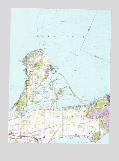
Gypsum, OH USGS Topographic Map
Click on map above to begin viewing in our Map Viewer.

This topographic map contains these locations and features:
Feature Name Type Latitude Longitude GNIS ID View Map
American Eagle ShoalBarN41.5967°W82.7535°1037403View Map
Bass HavenLocaleN41.5334°W82.8077°1083393View Map
Bergman OrchardsLocaleN41.5067°W82.8456°2518648View Map
Blackberry TrailTrailN41.5473°W82.8141°1963116View Map
Catawba IslandIslandN41.5642°W82.8396°1061348View Map
Catawba IslandPopulated PlaceN41.5853°W82.8369°1060928View Map
Catawba Island CemeteryCemeteryN41.5569°W82.8395°1038875View Map
Catawba Island ClubLocaleN41.5689°W82.8546°1067149View Map
Catawba Island Club Golf CourseLocaleN41.5701°W82.8491°1049703View Map
Catawba Island MarinaLocaleN41.5692°W82.8524°1049705View Map
Catawba Island Post OfficePost OfficeN41.5848°W82.8374°2041293View Map
Catawba Island State ParkParkN41.5751°W82.8571°1060929View Map
Catawba Island Township Police DepartmentBuildingN41.5563°W82.8419°2732516View Map
Catawba Island Volunteer Fire DepartmentBuildingN41.5563°W82.8436°2549676View Map
Catawba SchoolSchoolN41.5720°W82.8455°1049704View Map
Chafees MarinaLocaleN41.5637°W82.8266°1083395View Map
Channel Grove MarinaLocaleN41.5356°W82.7860°1077484View Map
Danbury Elementary SchoolSchoolN41.5363°W82.7550°1049708View Map
Danbury High SchoolSchoolN41.5365°W82.7548°1049707View Map
Danbury Township Police DepartmentBuildingN41.5286°W82.8302°2732947View Map
Danbury Township Volunteer Fire Department - Station 1 HeadquartersBuildingN41.5372°W82.7526°2549682View Map
Danbury Township Volunteer Fire Department - Station 2BuildingN41.5289°W82.8304°2780600View Map
Dewelle CemeteryCemeteryN41.5071°W82.8560°1039691View Map
East HarborBayN41.5392°W82.8046°1039996View Map
East Harbor Boat EntranceChannelN41.5406°W82.7849°1963117View Map
East Harbor State ParkParkN41.5476°W82.8099°1039997View Map
East Harbor State Park MarinaLocaleN41.5578°W82.8216°1083397View Map
Erie-Ottawa International AirportAirportN41.5094°W82.8702°1082968View Map
FoxhavenPopulated PlaceN41.5645°W82.8280°1077485View Map
Gem BeachPopulated PlaceN41.5695°W82.8224°1040809View Map
Harbor AcresPopulated PlaceN41.5481°W82.8319°1083399View Map
Harbor HavenLocaleN41.5323°W82.8149°1077486View Map
Herls HarborLocaleN41.5559°W82.8302°1083401View Map
Holiday CoveHarborN41.5417°W82.7666°1077487View Map
K'burg CemeteryCemeteryN41.5589°W82.8464°1964661View Map
Kenykirk HarborLocaleN41.5464°W82.8555°1067151View Map
Kenykirk HarborHarborN41.5467°W82.8560°1049700View Map
Lakeside Association DockLocaleN41.5470°W82.7507°1083403View Map
Lakeside Census Designated PlaceCensusN41.5409°W82.7534°2628923View Map
Lakeside ReefBarN41.5523°W82.7524°1964253View Map
Lakeside Volunteer Fire Department Station 2BuildingN41.5289°W82.8304°2550468View Map
Lakevue MarinaLocaleN41.5389°W82.7710°1077488View Map
Limpert MarinaLocaleN41.5401°W82.7699°1077489View Map
Lockwood CemeteryCemeteryN41.5437°W82.8163°1964663View Map
Marblehead Fire Department - Station 2BuildingN41.5083°W82.8286°2550336View Map
Marblehead PeninsulaCapeN41.5223°W82.7916°1065884View Map
Marina Del IsleLocaleN41.5339°W82.8044°1083407View Map
Marine City Yacht ClubLocaleN41.5351°W82.7935°1077490View Map
Meadow BrookStreamN41.5051°W82.7757°1043190View Map
Middle HarborBayN41.5545°W82.8121°1043277View Map
Middle Harbor ShoalBarN41.5687°W82.7946°1058177View Map
Middle Harbor TrailTrailN41.5492°W82.8202°1963118View Map
Moore PointCapeN41.5767°W82.8596°1079583View Map
Mouse IslandIslandN41.5912°W82.8330°1043677View Map
Mouse Island ReefBarN41.6067°W82.8327°1043678View Map
North Swimming BeachBeachN41.5578°W82.8027°1963119View Map
Piccola (historical)Populated PlaceN41.5189°W82.7813°1071043View Map
Piccolo Post Office (historical)Post OfficeN41.5195°W82.7819°2041303View Map
Portage Elementary SchoolSchoolN41.5078°W82.8702°1049699View Map
Sackett CemeteryCemeteryN41.5305°W82.7869°1045306View Map
Saint Paul Lutheran Church of DanburyChurchN41.5242°W82.8077°1045774View Map
Saint Pauls Lutheran CemeteryCemeteryN41.5243°W82.8049°1964668View Map
Schmardebeck DitchCanalN41.5092°W82.8352°1046004View Map
Scott PointCapeN41.5878°W82.8332°1079589View Map
Scott Point ShoalBarN41.5989°W82.8124°1046064View Map
South Beach TrailTrailN41.5403°W82.7877°1963120View Map
South PassageChannelN41.5731°W82.7677°1046488View Map
South ShoalBarN41.5953°W82.7880°1046497View Map
Starve Island ReefBarN41.6128°W82.8155°1046649View Map
Sugar RockSummitN41.5656°W82.8557°1063040View Map
Sugar Rock Harbor MarinaLocaleN41.5634°W82.8499°1049702View Map
The Colony Club HarborLocaleN41.5542°W82.8555°1067150View Map
The Colony Club HarborHarborN41.5542°W82.8546°1049701View Map
Tibbels MarinaLocaleN41.5345°W82.8019°1077492View Map
Township of Catawba IslandCivilN41.5675°W82.8488°1086758View Map
Township of DanburyCivilN41.5258°W82.7543°1086760View Map
Treasure Cove MarinaLocaleN41.5617°W82.8282°1083413View Map
Truman MarinaLocaleN41.5403°W82.7691°1077493View Map
Union ChapelChurchN41.5826°W82.8355°1047307View Map
Violet (historical)Populated PlaceN41.5181°W82.8077°1049706View Map
West HarborBayN41.5598°W82.8249°1047763View Map
West Harbor Boat EntranceChannelN41.5637°W82.8149°1963121View Map
West Harbor ReefBarN41.5773°W82.8038°1048431View Map
West Harbor TrailTrailN41.5631°W82.8144°1963122View Map
Wetlands TrailTrailN41.5501°W82.8013°1963123View Map
Winkes MarinaLocaleN41.5542°W82.8305°1077494View Map

Note: Coordinates in the location and feature list above are referenced to NAD83 datum.


Copyright (C) 2008-2024 Ryan Niemi / Sunset Dynamics ... All Rights Reserved