TopoQuest Logo
Do you find TopoQuest useful?
Help keep TopoQuest running and adding new maps/features by donating!
Bitcoin:  19c7KJd3qBynnjoSw5npx9KScwjBe4ifkT
Litecoin:  LXs6TkuXGGXo1vDsWCkWVdjQX94eUKd6ui
Home View Maps Find Maps Find Places Resources & Links


Hackett Mountain, Colorado Topographic Map

USGS Map Title: Hackett Mountain, CO
USGS Map MRC: 39105A3
DRG (GeoTIFF) Download: o39105a3.tif


Neighboring USGS Topographic Map Quads:


  McCurdy Mountain, CO  
39105B4
 

  Cheesman Lake, CO  
39105B3
 

  Westcreek, CO  
39105B2
 

  Tarryall, CO  
39105A4
 

  Hackett Mountain, CO  
39105A3
 

  Signal Butte, CO  
39105A2
 

  Elevenmile Canyon, CO  
38105H4
 

  Lake George, CO  
38105H3
 

  Divide, CO  
38105H2


Map MRC Location:

N40°
W106°
N40°
W105°
H8 H7 H6 H5 H4 H3 H2 H1
G8 G7 G6 G5 G4 G3 G2 G1
F8 F7 F6 F5 F4 F3 F2 F1
E8 E7 E6 E5 E4 E3 E2 E1
D8 D7 D6 D5 D4 D3 D2 D1
C8 C7 C6 C5 C4 C3 C2 C1
B8 B7 B6 B5 B4 B3 B2 B1
A8 A7 A6 A5 A4 A3 A2 A1
N39°
W106°
N39°
W105°

Hackett Mountain, CO USGS 1:24K Topographic Map Preview:
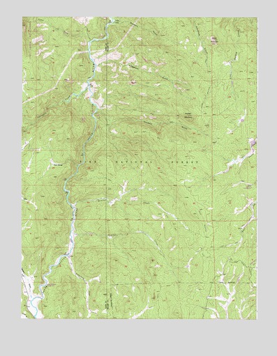
Hackett Mountain, CO USGS Topographic Map
Click on map above to begin viewing in our Map Viewer.

This topographic map contains these locations and features:
Feature Name Type Latitude Longitude GNIS ID View Map
Air Line MineMineN39.0003°W105.3005°1735885View Map
Beaver CreekStreamN39.0378°W105.3483°183836View Map
Cedar MountainSummitN39.1158°W105.2680°183839View Map
Corral CreekStreamN39.1150°W105.3383°183682View Map
Crystal CreekStreamN39.0355°W105.3489°183835View Map
Custer CabinsLocaleN39.1233°W105.3261°183834View Map
Florissant Fire and Rescue Station 3BuildingN39.0120°W105.2826°2666961View Map
Hackett GulchValleyN39.0867°W105.3347°183838View Map
Hackett MountainSummitN39.0844°W105.2869°183840View Map
Hilda May Number One Claim MineMineN39.1053°W105.2967°1703843View Map
Hoder Recreation DamDamN39.0733°W105.2539°198840View Map
Hoder Recreation ReservoirReservoirN39.0729°W105.2524°198841View Map
Lake George MineMineN39.0033°W105.3700°1703842View Map
Longwater GulchValleyN39.1047°W105.3357°183841View Map
Longwater TrailTrailN39.0792°W105.3478°202961View Map
Metberry GulchValleyN39.1231°W105.3270°183833View Map
Mountain Communities Fire Protection District Station 3 Lutheran ValleyBuildingN39.0839°W105.2581°2695565View Map
Platte SpringsPopulated PlaceN39.0636°W105.3586°183843View Map
Tappan GulchValleyN39.0086°W105.3698°183822View Map
Tappan Mountain Prospect PitMineN39.0769°W105.3747°1703840View Map
Tarryall CreekStreamN39.0969°W105.3397°183410View Map
Two Bit Claims MineMineN39.0194°W105.3736°1703841View Map
Vermillion CreekStreamN39.0261°W105.3503°183842View Map
Wildhorn RanchLocaleN39.0672°W105.2578°183837View Map

Note: Coordinates in the location and feature list above are referenced to NAD83 datum.


Copyright (C) 2008-2024 Ryan Niemi / Sunset Dynamics ... All Rights Reserved