TopoQuest Logo
Do you find TopoQuest useful?
Help keep TopoQuest running and adding new maps/features by donating!
Bitcoin:  19c7KJd3qBynnjoSw5npx9KScwjBe4ifkT
Litecoin:  LXs6TkuXGGXo1vDsWCkWVdjQX94eUKd6ui
Home View Maps Find Maps Find Places Resources & Links


Tarryall, Colorado Topographic Map

USGS Map Title: Tarryall, CO
USGS Map MRC: 39105A4
DRG (GeoTIFF) Download: o39105a4.tif


Neighboring USGS Topographic Map Quads:


  Farnum Peak, CO  
39105B5
 

  McCurdy Mountain, CO  
39105B4
 

  Cheesman Lake, CO  
39105B3
 

  Glentivar, CO  
39105A5
 

  Tarryall, CO  
39105A4
 

  Hackett Mountain, CO  
39105A3
 

  Spinney Mountain, CO  
38105H5
 

  Elevenmile Canyon, CO  
38105H4
 

  Lake George, CO  
38105H3


Map MRC Location:

N40°
W106°
N40°
W105°
H8 H7 H6 H5 H4 H3 H2 H1
G8 G7 G6 G5 G4 G3 G2 G1
F8 F7 F6 F5 F4 F3 F2 F1
E8 E7 E6 E5 E4 E3 E2 E1
D8 D7 D6 D5 D4 D3 D2 D1
C8 C7 C6 C5 C4 C3 C2 C1
B8 B7 B6 B5 B4 B3 B2 B1
A8 A7 A6 A5 A4 A3 A2 A1
N39°
W106°
N39°
W105°

Tarryall, CO USGS 1:24K Topographic Map Preview:
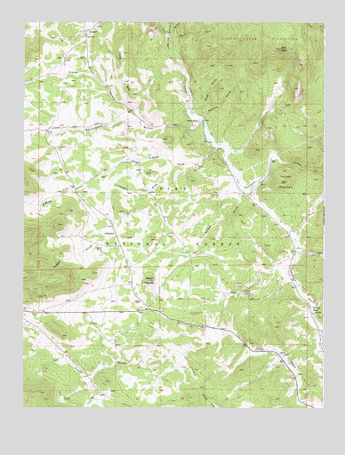
Tarryall, CO USGS Topographic Map
Click on map above to begin viewing in our Map Viewer.

This topographic map contains these locations and features:
Feature Name Type Latitude Longitude GNIS ID View Map
A and C Claim MineMineN39.1019°W105.4747°1703834View Map
Alexander DrawValleyN39.0788°W105.4376°183825View Map
Badger Flats Airstrip (historical)AirportN39.0586°W105.4631°183827View Map
Badger GulchValleyN39.0700°W105.4092°183824View Map
Badger SpringSpringN39.0524°W105.4695°183826View Map
Beaver Dam CreekStreamN39.1208°W105.4400°183681View Map
Boomer MineMineN39.0758°W105.4489°1703835View Map
China WallRidgeN39.1136°W105.4539°196561View Map
East Fork Beaver Dam CreekStreamN39.1217°W105.4392°183680View Map
Flume DitchCanalN39.1014°W105.4308°2712090View Map
HaymanLocaleN39.0364°W105.4067°196386View Map
Hazel Marie Claims MineMineN39.1111°W105.4517°1703836View Map
Hill Top Claims MineMineN39.0222°W105.3933°1703833View Map
Krebill DitchCanalN39.0896°W105.4252°2723094View Map
Lake George Fire Protection District Station 4BuildingN39.1229°W105.4716°2695567View Map
Landis RanchLocaleN39.0928°W105.4278°183831View Map
Marksbury GulchValleyN39.0934°W105.4270°183811View Map
Mary B MineMineN39.0569°W105.4628°1703837View Map
Mary Lee Prospect MineMineN39.0755°W105.4286°1703829View Map
McLaughlin DitchCanalN39.0698°W105.4063°2723530View Map
O'Brien GulchValleyN39.0841°W105.4205°183804View Map
Pilot PeakSummitN39.1164°W105.3936°183828View Map
Reader CreekStreamN39.1197°W105.4400°183679View Map
Redskin Claims MineMineN39.0922°W105.4294°1703830View Map
Redskin GulchValleyN39.0931°W105.4254°183830View Map
Round MountainSummitN39.0305°W105.4317°196739View Map
Round MountainSummitN39.0411°W105.4478°183821View Map
Round Mountain Claims MineMineN39.0392°W105.4397°1703838View Map
Saint Joe TunnelMineN39.0355°W105.4942°183818View Map
Shamrock-Irish Group MineMineN39.0786°W105.4481°1703831View Map
Spud GulchValleyN39.0976°W105.4302°183829View Map
Tappan MountainSummitN39.0733°W105.3911°183823View Map
TarryallPopulated PlaceN39.1219°W105.4756°183832View Map
Tarryall Creek MineMineN39.0753°W105.3936°1703839View Map
Thorpe GulchValleyN39.0923°W105.4510°183810View Map
Warlings RanchLocaleN39.0314°W105.3803°183819View Map
Wheel of Fortune MineMineN39.0628°W105.3936°1703832View Map

Note: Coordinates in the location and feature list above are referenced to NAD83 datum.


Copyright (C) 2008-2025 Ryan Niemi / Sunset Dynamics ... All Rights Reserved