TopoQuest Logo
Do you find TopoQuest useful?
Help keep TopoQuest running and adding new maps/features by donating!
Bitcoin:  19c7KJd3qBynnjoSw5npx9KScwjBe4ifkT
Litecoin:  LXs6TkuXGGXo1vDsWCkWVdjQX94eUKd6ui
Home View Maps Find Maps Find Places Resources & Links


Hamilton, Illinois Topographic Map

USGS Map Title: Hamilton, IL
USGS Map MRC: 40091D3
DRG (GeoTIFF) Download: o40091d3.tif


Neighboring USGS Topographic Map Quads:


  Nauvoo, IL  
40091E4
 

  Niota, IL  
40091E3
 

  Colusa, IL  
40091E2
 

  Keokuk, IA  
40091D4
 

  Hamilton, IL  
40091D3
 

  Carthage West, IL  
40091D2
 

  Warsaw, IL  
40091C4
 

  Sutter, IL  
40091C3
 

  West Point, IL  
40091C2


Map MRC Location:

N41°
W92°
N41°
W91°
H8 H7 H6 H5 H4 H3 H2 H1
G8 G7 G6 G5 G4 G3 G2 G1
F8 F7 F6 F5 F4 F3 F2 F1
E8 E7 E6 E5 E4 E3 E2 E1
D8 D7 D6 D5 D4 D3 D2 D1
C8 C7 C6 C5 C4 C3 C2 C1
B8 B7 B6 B5 B4 B3 B2 B1
A8 A7 A6 A5 A4 A3 A2 A1
N40°
W92°
N40°
W91°

Hamilton, IL USGS 1:24K Topographic Map Preview:
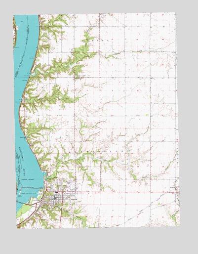
Hamilton, IL USGS Topographic Map
Click on map above to begin viewing in our Map Viewer.

This topographic map contains these locations and features:
Feature Name Type Latitude Longitude GNIS ID View Map
Bethel Presbyterian ChurchChurchN40.3934°W91.3393°1986067View Map
Chaney CreekStreamN40.4075°W91.3521°405953View Map
City of HamiltonCivilN40.3899°W91.3623°2394275View Map
Crystal Glen CreekStreamN40.3850°W91.3746°406864View Map
Elvaston Post OfficePost OfficeN40.3951°W91.2502°2788885View Map
Eureka School (historical)SchoolN40.4470°W91.2715°1720597View Map
Fairview School (historical)SchoolN40.4400°W91.3096°1720599View Map
First Christian ChurchChurchN40.3923°W91.3474°1986068View Map
Gibralter School (historical)SchoolN40.4781°W91.3429°1720602View Map
Golden Point School (historical)SchoolN40.4778°W91.3096°1720603View Map
Goldens Point ChurchChurchN40.4625°W91.3282°409125View Map
Gray QuarryMineN40.3842°W91.3579°1986084View Map
Grays BayBayN40.4289°W91.3663°409355View Map
Greenwood CemeteryCemeteryN40.3875°W91.3496°409459View Map
HamiltonPopulated PlaceN40.3964°W91.3390°409689View Map
Hamilton Fire DepartmentBuildingN40.3938°W91.3456°2640862View Map
Hamilton High SchoolSchoolN40.3962°W91.3440°1812495View Map
Hamilton Police DepartmentBuildingN40.3929°W91.3451°2757074View Map
Hamilton Post OfficePost OfficeN40.3928°W91.3430°2788678View Map
Hyndman School (historical)SchoolN40.4178°W91.2726°1720609View Map
Keokuk DamDamN40.3992°W91.3627°464422View Map
Keokuk DamDamN40.3991°W91.3639°411419View Map
KOKX-AM (Keokuk)TowerN40.3806°W91.3527°467041View Map
Larry CreekStreamN40.4659°W91.3624°411837View Map
Larry School (historical)SchoolN40.4759°W91.2704°1720611View Map
Leyman School (historical)SchoolN40.4403°W91.3299°1720612View Map
Lock and Dam Number NineteenDamN40.3975°W91.2649°424532View Map
Lock Number 19DamN40.3953°W91.3735°425130View Map
Lock Number 19DamN40.3951°W91.3737°465870View Map
Mississippi Lock Number 019DamN40.3984°W91.3635°1692655View Map
Montebello State ParkParkN40.3939°W91.3635°413740View Map
Mount MoriahSummitN40.4673°W91.3610°413827View Map
North Branch Larry CreekStreamN40.4759°W91.3185°414568View Map
Oak Grove CemeteryCemeteryN40.4639°W91.3274°414775View Map
Oakwood CemeteryCemeteryN40.4020°W91.3346°414928View Map
Pool 19ReservoirN40.4085°W91.3688°2747505View Map
Railroad CreekStreamN40.3950°W91.3574°416351View Map
Riverview School (historical)SchoolN40.4378°W91.3704°1720627View Map
Saint Marys Catholic ChurchChurchN40.4009°W91.3504°1986069View Map
Sanobia Church (historical)ChurchN40.4925°W91.3465°1720629View Map
Sonora (historical)Populated PlaceN40.4942°W91.3549°1812508View Map
South Branch Larry CreekStreamN40.4759°W91.3185°418726View Map
Sterns CemeteryCemeteryN40.4781°W91.3285°419107View Map
Sullivan AirportAirportN40.4007°W91.3073°2679050View Map
Township of MontebelloCivilN40.4179°W91.3170°429386View Map
Waggoner CreekStreamN40.4509°W91.3690°420369View Map
Washington School (historical)SchoolN40.3964°W91.3026°1720636View Map
Wildcat Springs ParkParkN40.4039°W91.3502°421158View Map

Note: Coordinates in the location and feature list above are referenced to NAD83 datum.


Copyright (C) 2008-2025 Ryan Niemi / Sunset Dynamics ... All Rights Reserved