TopoQuest Logo
Do you find TopoQuest useful?
Help keep TopoQuest running and adding new maps/features by donating!
Bitcoin:  19c7KJd3qBynnjoSw5npx9KScwjBe4ifkT
Litecoin:  LXs6TkuXGGXo1vDsWCkWVdjQX94eUKd6ui
Home View Maps Find Maps Find Places Resources & Links


Sutter, Illinois Topographic Map

USGS Map Title: Sutter, IL
USGS Map MRC: 40091C3
DRG (GeoTIFF) Download: o40091c3.tif


Neighboring USGS Topographic Map Quads:


  Keokuk, IA  
40091D4
 

  Hamilton, IL  
40091D3
 

  Carthage West, IL  
40091D2
 

  Warsaw, IL  
40091C4
 

  Sutter, IL  
40091C3
 

  West Point, IL  
40091C2
 

  Lima, IL  
40091B4
 

  Tioga, IL  
40091B3
 

  Loraine, IL  
40091B2


Map MRC Location:

N41°
W92°
N41°
W91°
H8 H7 H6 H5 H4 H3 H2 H1
G8 G7 G6 G5 G4 G3 G2 G1
F8 F7 F6 F5 F4 F3 F2 F1
E8 E7 E6 E5 E4 E3 E2 E1
D8 D7 D6 D5 D4 D3 D2 D1
C8 C7 C6 C5 C4 C3 C2 C1
B8 B7 B6 B5 B4 B3 B2 B1
A8 A7 A6 A5 A4 A3 A2 A1
N40°
W92°
N40°
W91°

Sutter, IL USGS 1:24K Topographic Map Preview:
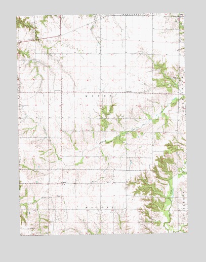
Sutter, IL USGS Topographic Map
Click on map above to begin viewing in our Map Viewer.

This topographic map contains these locations and features:
Feature Name Type Latitude Longitude GNIS ID View Map
Bethlehem ChurchChurchN40.2792°W91.3215°404344View Map
Bethlehem Church of Christ CemeteryCemeteryN40.2798°W91.3221°1983975View Map
EldervillePopulated PlaceN40.3303°W91.2946°422661View Map
Elm Grove School (historical)SchoolN40.2578°W91.3440°1720596View Map
Excelsior School (historical)SchoolN40.3312°W91.3735°1720598View Map
Froggy School (historical)SchoolN40.3584°W91.2735°1720601View Map
Grant CemeteryCemeteryN40.2539°W91.3676°409286View Map
Harmony School (historical)SchoolN40.3603°W91.3513°1720606View Map
McGee CemeteryCemeteryN40.3381°W91.2557°413264View Map
Mount Vernon School (historical)SchoolN40.3095°W91.3396°1720619View Map
Oak Grove School (historical)SchoolN40.3153°W91.2993°1720622View Map
Orange School (historical)SchoolN40.2864°W91.2949°1720623View Map
Prairie School (historical)SchoolN40.3295°W91.2804°1720625View Map
Salem ChurchChurchN40.2792°W91.3093°417879View Map
Salem Church-Sutter CemeteryCemeteryN40.2798°W91.3099°1983977View Map
SutterPopulated PlaceN40.2792°W91.3435°419436View Map
Sylvandale School (historical)SchoolN40.3070°W91.2568°1720631View Map
Township of WytheCivilN40.3306°W91.3146°429964View Map
Walker CemeteryCemeteryN40.2578°W91.3526°420402View Map
Walnut Grove School (historical)SchoolN40.3600°W91.3129°1720633View Map
WCAZ-AM (Carthage)TowerN40.2792°W91.2949°428133View Map
Wythe Congregational CemeteryCemeteryN40.3239°W91.3729°406466View Map
Wythe Presbyterian CemeteryCemeteryN40.3320°W91.3426°421543View Map
Wythe School (historical)SchoolN40.3309°W91.3182°1720643View Map

Note: Coordinates in the location and feature list above are referenced to NAD83 datum.


Copyright (C) 2008-2025 Ryan Niemi / Sunset Dynamics ... All Rights Reserved