TopoQuest Logo
Do you find TopoQuest useful?
Help keep TopoQuest running and adding new maps/features by donating!
Bitcoin:  19c7KJd3qBynnjoSw5npx9KScwjBe4ifkT
Litecoin:  LXs6TkuXGGXo1vDsWCkWVdjQX94eUKd6ui
Home View Maps Find Maps Find Places Resources & Links


Hamilton, Mississippi Topographic Map

USGS Map Title: Hamilton, MS
USGS Map MRC: 33088F4
DRG (GeoTIFF) Download: o33088f4.tif


Neighboring USGS Topographic Map Quads:


  Aberdeen, MS  
33088G5
 

  Amory SW, MS  
33088G4
 

  Amory SE, MS  
33088G3
 

  Strong, MS  
33088F5
 

  Hamilton, MS  
33088F4
 

  Caledonia, MS  
33088F3
 

  Waverly, MS  
33088E5
 

  Columbus North, MS  
33088E4
 

  Steens, MS  
33088E3


Map MRC Location:

N34°
W89°
N34°
W88°
H8 H7 H6 H5 H4 H3 H2 H1
G8 G7 G6 G5 G4 G3 G2 G1
F8 F7 F6 F5 F4 F3 F2 F1
E8 E7 E6 E5 E4 E3 E2 E1
D8 D7 D6 D5 D4 D3 D2 D1
C8 C7 C6 C5 C4 C3 C2 C1
B8 B7 B6 B5 B4 B3 B2 B1
A8 A7 A6 A5 A4 A3 A2 A1
N33°
W89°
N33°
W88°

Hamilton, MS USGS 1:24K Topographic Map Preview:
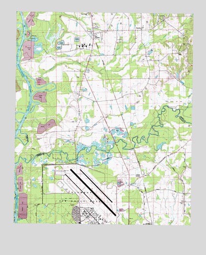
Hamilton, MS USGS Topographic Map
Click on map above to begin viewing in our Map Viewer.

This topographic map contains these locations and features:
Feature Name Type Latitude Longitude GNIS ID View Map
Andrews Chapel (historical)ChurchN33.6359°W88.4567°687710View Map
Barton Ferry CutoffChannelN33.6348°W88.4984°690823View Map
Bartons Ferry (historical)CrossingN33.6412°W88.4973°687734View Map
Bethel ChurchChurchN33.7118°W88.4550°666940View Map
Botters CemeteryCemeteryN33.6387°W88.3798°667461View Map
Cane Creek CutoffChannelN33.7279°W88.4895°690768View Map
Cedar Grove ChurchChurchN33.6618°W88.4603°687759View Map
Cedar Grove CreekStreamN33.7171°W88.4375°668205View Map
Center Hill Baptist ChurchChurchN33.7487°W88.3950°668238View Map
Chins Springs (historical)Populated PlaceN33.6771°W88.3964°687765View Map
Columbus Air Force BaseMilitaryN33.6411°W88.4498°2512152View Map
Columbus Air Force BaseAirportN33.6356°W88.4451°2676392View Map
Columbus Air Force Base Census Designated PlaceCensusN33.6276°W88.4454°2402790View Map
Columbus Air Force Base Fire DepartmentBuildingN33.6369°W88.4536°2666018View Map
Corinne Gas FieldOilfieldN33.6668°W88.4625°690769View Map
Denman BranchStreamN33.6968°W88.4984°709333View Map
Denmon CutoffChannelN33.6862°W88.4939°690770View Map
Doalms Ferry (historical)CrossingN33.6673°W88.4553°687787View Map
Ebenezer Primitive Baptist Church (historical)ChurchN33.7173°W88.4487°709334View Map
HamiltonPopulated PlaceN33.7404°W88.4112°670857View Map
Hamilton Census Designated PlaceCensusN33.7460°W88.4095°2586595View Map
Hamilton Church of ChristChurchN33.7398°W88.4317°709347View Map
Hamilton Gas FieldOilfieldN33.7237°W88.4070°690771View Map
Hamilton LandingLocaleN33.7001°W88.4878°709348View Map
Hamilton Post OfficePost OfficeN33.7354°W88.4450°2768725View Map
Hamilton Presbyterian ChurchChurchN33.7398°W88.4145°687414View Map
Hamilton Primitive Baptist ChurchChurchN33.6982°W88.4331°709349View Map
Hamilton Public LibraryBuildingN33.7346°W88.4450°687415View Map
Hamilton United Methodist ChurchChurchN33.7390°W88.4412°687416View Map
Horseshoe BendBendN33.6751°W88.4945°706960View Map
Indian Ford (historical)CrossingN33.6951°W88.4839°709354View Map
J G Fairchilds Pond DamDamN33.7284°W88.4034°682314View Map
Ker Magee Lake DamDamN33.7368°W88.4617°682321View Map
Kolola SpringsPopulated PlaceN33.6540°W88.4089°672212View Map
Kolola Springs Baptist ChurchChurchN33.6559°W88.4050°687846View Map
Lockridge Creek CutoffChannelN33.7390°W88.4945°690773View Map
Lowndes County District 2 Volunteer Fire and Rescue Department Kolola Springs StationBuildingN33.6535°W88.4087°2666016View Map
Maple BranchStreamN33.6987°W88.3770°673119View Map
Maple Branch Gas FieldOilfieldN33.6987°W88.3875°690774View Map
McKinley CreekStreamN33.7084°W88.4767°673383View Map
McKinley Creek Access AreaParkN33.7168°W88.4917°687432View Map
McKinley Creek CutoffChannelN33.7084°W88.4917°690775View Map
McKinley Creek Gas FieldOilfieldN33.7209°W88.4681°690776View Map
Mealer Lake (historical)LakeN33.6779°W88.4978°706961View Map
New HamiltonPopulated PlaceN33.7379°W88.4448°674635View Map
New Hamilton Census Designated PlaceCensusN33.7435°W88.4389°2586606View Map
New Hamilton CutoffChannelN33.7307°W88.4962°690778View Map
Otter Lake (historical)LakeN33.6946°W88.4895°709370View Map
Richardson Lake CutoffChannelN33.7251°W88.4987°690781View Map
Running SloughStreamN33.6935°W88.3837°676953View Map
Saint Thomas School (historical)SchoolN33.6651°W88.3870°687913View Map
Sardis CemeteryCemeteryN33.7321°W88.3792°677413View Map
Shell FieldFlatN33.7168°W88.4806°709383View Map
Sixteenth Section School (historical)SchoolN33.6482°W88.4139°687920View Map
Smallwood LandingLocaleN33.7165°W88.4959°709384View Map
Southeast Monroe County Volunteer Fire DepartmentBuildingN33.7394°W88.4253°2665685View Map
Sulphur Springs ChurchChurchN33.7496°W88.4495°687470View Map
Sulphur Springs SchoolSchoolN33.7498°W88.4500°678396View Map
Tatums LandingLocaleN33.6901°W88.4914°709394View Map
Travis Lott BendBendN33.7057°W88.4764°709401View Map
Valley ChapelChurchN33.7268°W88.3842°679169View Map
Vinton CutoffChannelN33.6793°W88.4978°690783View Map
Wilson CreekStreamN33.7171°W88.4375°679767View Map

Note: Coordinates in the location and feature list above are referenced to NAD83 datum.


Copyright (C) 2008-2025 Ryan Niemi / Sunset Dynamics ... All Rights Reserved