TopoQuest Logo
Do you find TopoQuest useful?
Help keep TopoQuest running and adding new maps/features by donating!
Bitcoin:  19c7KJd3qBynnjoSw5npx9KScwjBe4ifkT
Litecoin:  LXs6TkuXGGXo1vDsWCkWVdjQX94eUKd6ui
Home View Maps Find Maps Find Places Resources & Links


Harden City, Oklahoma Topographic Map

USGS Map Title: Harden City, OK
USGS Map MRC: 34096E5
DRG (GeoTIFF) Download: o34096e5.tif


Neighboring USGS Topographic Map Quads:


  Ahloso, OK  
34096F6
 

  Stonewall, OK  
34096F5
 

  Lula, OK  
34096F4
 

  Fittstown, OK  
34096E6
 

  Harden City, OK  
34096E5
 

  Tupelo, OK  
34096E4
 

  Connerville, OK  
34096D6
 

  Connerville NE, OK  
34096D5
 

  Wapanucka North, OK  
34096D4


Map MRC Location:

N35°
W97°
N35°
W96°
H8 H7 H6 H5 H4 H3 H2 H1
G8 G7 G6 G5 G4 G3 G2 G1
F8 F7 F6 F5 F4 F3 F2 F1
E8 E7 E6 E5 E4 E3 E2 E1
D8 D7 D6 D5 D4 D3 D2 D1
C8 C7 C6 C5 C4 C3 C2 C1
B8 B7 B6 B5 B4 B3 B2 B1
A8 A7 A6 A5 A4 A3 A2 A1
N34°
W97°
N34°
W96°

Harden City, OK USGS 1:24K Topographic Map Preview:
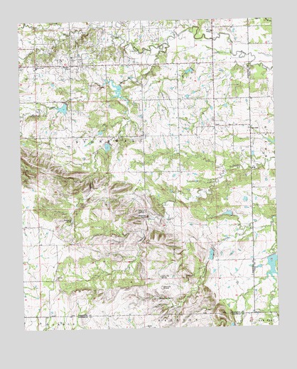
Harden City, OK USGS Topographic Map
Click on map above to begin viewing in our Map Viewer.

This topographic map contains these locations and features:
Feature Name Type Latitude Longitude GNIS ID View Map
Atkins CemeteryCemeteryN34.6101°W96.5995°1089742View Map
Biscuit KnobSummitN34.5165°W96.5572°1090166View Map
Canyon CreekStreamN34.5912°W96.5722°1090939View Map
Coffee Pot SpringSpringN34.5205°W96.5578°1091539View Map
Deadmans SpringSpringN34.5447°W96.6008°1091980View Map
East JessePopulated PlaceN34.5812°W96.5122°1092412View Map
Fitts Oil FieldOilfieldN34.6037°W96.5683°1092850View Map
Gobbler KnobSummitN34.5456°W96.5639°1093225View Map
Harden CityPopulated PlaceN34.6073°W96.5997°1093527View Map
JessePopulated PlaceN34.5820°W96.5297°1094217View Map
Jesse CemeteryCemeteryN34.5850°W96.5300°2711558View Map
Lonegrove CemeteryCemeteryN34.6178°W96.6228°2664216View Map
Mill CreekStreamN34.6193°W96.5786°1095402View Map
Oknoname 123017 DamDamN34.5801°W96.5853°1753475View Map
Oknoname 123017 ReservoirReservoirN34.5798°W96.5858°1753476View Map
Pontotoc Ridge Preserve Fire ProtectionBuildingN34.5246°W96.6085°2657351View Map
Sheep CreekStreamN34.6151°W96.5514°1097975View Map
Township of StonewallCivilN34.6084°W96.5697°1824977View Map
Upper Clear Boggy Creek Site 13 DamDamN34.5001°W96.5219°1750883View Map
Upper Clear Boggy Creek Site 13 ReservoirReservoirN34.5003°W96.5232°1750884View Map
Upper Clear Boggy Creek Site 14 DamDamN34.5318°W96.5319°1757139View Map
Upper Clear Boggy Creek Site 14 DamDamN34.5318°W96.5319°1755131View Map
Upper Clear Boggy Creek Site 14 ReservoirReservoirN34.5297°W96.5327°1757140View Map
Upper Clear Boggy Creek Site 15 DamDamN34.5451°W96.5219°1757141View Map
Upper Clear Boggy Creek Site 15 DamDamN34.5468°W96.5219°1755133View Map
Upper Clear Boggy Creek Site 15 ReservoirReservoirN34.5462°W96.5237°1757142View Map
Upper Clear Boggy Creek Site 20 DamDamN34.5734°W96.5003°1752279View Map
Upper Clear Boggy Creek Site 20 ReservoirReservoirN34.5749°W96.5022°1752280View Map
Upper Clear Boggy Creek Site 22 DamDamN34.6051°W96.5403°1757143View Map
Upper Clear Boggy Creek Site 22 ReservoirReservoirN34.6043°W96.5416°1757144View Map
Upper Clear Boggy Creek Site 23 DamDamN34.5984°W96.5753°1757145View Map
Upper Clear Boggy Creek Site 23 ReservoirReservoirN34.5971°W96.5773°1757146View Map
Upper Clear Boggy Creek Site 24 DamDamN34.5751°W96.5819°1757147View Map
Upper Clear Boggy Creek Site 24 ReservoirReservoirN34.5741°W96.5824°1757148View Map
Upper Clear Boggy Creek Site 25 DamDamN34.5918°W96.6020°1757149View Map
Upper Clear Boggy Creek Site 25 ReservoirReservoirN34.5899°W96.6040°1757150View Map
Upper Clear Boggy Creek Site 9 DamDamN34.5284°W96.5036°1751674View Map
Upper Clear Boggy Creek Site 9 ReservoirReservoirN34.5249°W96.5028°1751675View Map
Upper Clear Boggy Number 19 DamDamN34.5718°W96.5569°1755135View Map
Upper Clear Boggy Number 19 ReservoirReservoirN34.5718°W96.5569°1755136View Map
Walnut CreekStreamN34.6201°W96.6022°1099319View Map
Walnut SpringSpringN34.5127°W96.5586°1099336View Map
Wildcat SpringsSpringN34.5479°W96.5650°1099782View Map

Note: Coordinates in the location and feature list above are referenced to NAD83 datum.


Copyright (C) 2008-2024 Ryan Niemi / Sunset Dynamics ... All Rights Reserved