TopoQuest Logo
Do you find TopoQuest useful?
Help keep TopoQuest running and adding new maps/features by donating!
Bitcoin:  19c7KJd3qBynnjoSw5npx9KScwjBe4ifkT
Litecoin:  LXs6TkuXGGXo1vDsWCkWVdjQX94eUKd6ui
Home View Maps Find Maps Find Places Resources & Links


Connerville NE, Oklahoma Topographic Map

USGS Map Title: Connerville NE, OK
USGS Map MRC: 34096D5
DRG (GeoTIFF) Download: o34096d5.tif


Neighboring USGS Topographic Map Quads:


  Fittstown, OK  
34096E6
 

  Harden City, OK  
34096E5
 

  Tupelo, OK  
34096E4
 

  Connerville, OK  
34096D6
 

  Connerville NE, OK  
34096D5
 

  Wapanucka North, OK  
34096D4
 

  Reagan, OK  
34096C6
 

  Connerville SE, OK  
34096C5
 

  Wapanucka South, OK  
34096C4


Map MRC Location:

N35°
W97°
N35°
W96°
H8 H7 H6 H5 H4 H3 H2 H1
G8 G7 G6 G5 G4 G3 G2 G1
F8 F7 F6 F5 F4 F3 F2 F1
E8 E7 E6 E5 E4 E3 E2 E1
D8 D7 D6 D5 D4 D3 D2 D1
C8 C7 C6 C5 C4 C3 C2 C1
B8 B7 B6 B5 B4 B3 B2 B1
A8 A7 A6 A5 A4 A3 A2 A1
N34°
W97°
N34°
W96°

Connerville NE, OK USGS 1:24K Topographic Map Preview:
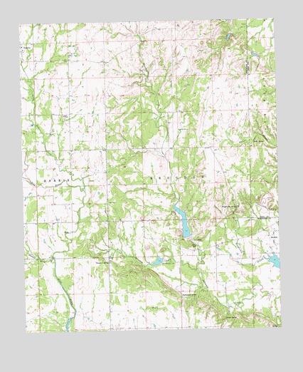
Connerville NE, OK USGS Topographic Map
Click on map above to begin viewing in our Map Viewer.

This topographic map contains these locations and features:
Feature Name Type Latitude Longitude GNIS ID View Map
Camp SimpsonLocaleN34.4109°W96.5408°1090878View Map
Deadman SpringSpringN34.4031°W96.5837°1091978View Map
Delaware Creek Site 10 DamDamN34.4018°W96.5003°1750869View Map
Delaware Creek Site 10 ReservoirReservoirN34.4013°W96.5009°1750870View Map
Delaware Creek Site 8 DamDamN34.4034°W96.5569°1750865View Map
Delaware Creek Site 8 ReservoirReservoirN34.4028°W96.5601°1750866View Map
Delaware Creek Site 9 DamDamN34.4118°W96.5453°1750867View Map
Delaware Creek Site 9 ReservoirReservoirN34.4177°W96.5465°1750868View Map
Diamond Spring BranchStreamN34.4051°W96.6108°1092077View Map
Houghtubby SpringSpringN34.4242°W96.5209°1093970View Map
Kelly SpringSpringN34.4503°W96.5068°1094317View Map
Little Blue CreekStreamN34.4329°W96.5947°1094714View Map
Little Delaware CreekStreamN34.3995°W96.5406°1094757View Map
Pilgrim CemeteryCemeteryN34.4270°W96.5836°1096632View Map
Pontotoc CemeteryCemeteryN34.4892°W96.6222°2709407View Map
Rutherford SpringSpringN34.3883°W96.5484°1097550View Map
Seeley CemeteryCemeteryN34.4556°W96.6122°1097900View Map
Seely ChapelChurchN34.4623°W96.6042°1097901View Map
Township of BrogdonCivilN34.4362°W96.5447°1824980View Map
Upper Clear Boggy Creek Site 11 DamDamN34.4851°W96.5086°1757137View Map
Upper Clear Boggy Creek Site 11 ReservoirReservoirN34.4855°W96.5103°1757138View Map
Upper Clear Boggy Creek Site 12 DamDamN34.4934°W96.5219°1750881View Map
Upper Clear Boggy Creek Site 12 ReservoirReservoirN34.4921°W96.5236°1750882View Map
Viola SpringSpringN34.3794°W96.5269°1099273View Map
Witch HoleLakeN34.4089°W96.5405°1099934View Map

Note: Coordinates in the location and feature list above are referenced to NAD83 datum.


Copyright (C) 2008-2024 Ryan Niemi / Sunset Dynamics ... All Rights Reserved