TopoQuest Logo
Do you find TopoQuest useful?
Help keep TopoQuest running and adding new maps/features by donating!
Bitcoin:  19c7KJd3qBynnjoSw5npx9KScwjBe4ifkT
Litecoin:  LXs6TkuXGGXo1vDsWCkWVdjQX94eUKd6ui
Home View Maps Find Maps Find Places Resources & Links


Hardin Ranch, Oregon Topographic Map

USGS Map Title: Hardin Ranch, OR
USGS Map MRC: 43119H8
DRG (GeoTIFF) Download: o43119h8.tif


Neighboring USGS Topographic Map Quads:


  Liggett Table, OR  
44120A1
 

  Maupin Butte, OR  
44119A8
 

  Angell Butte, OR  
44119A7
 

  Sand Hollow, OR  
43120H1
 

  Hardin Ranch, OR  
43119H8
 

  Twelvemile Reservoir, OR  
43119H7
 

  G I Ranch, OR  
43120G1
 

  Ibex Butte, OR  
43119G8
 

  Mackey Butte, OR  
43119G7


Map MRC Location:

N44°
W120°
N44°
W119°
H8 H7 H6 H5 H4 H3 H2 H1
G8 G7 G6 G5 G4 G3 G2 G1
F8 F7 F6 F5 F4 F3 F2 F1
E8 E7 E6 E5 E4 E3 E2 E1
D8 D7 D6 D5 D4 D3 D2 D1
C8 C7 C6 C5 C4 C3 C2 C1
B8 B7 B6 B5 B4 B3 B2 B1
A8 A7 A6 A5 A4 A3 A2 A1
N43°
W120°
N43°
W119°

Hardin Ranch, OR USGS 1:24K Topographic Map Preview:
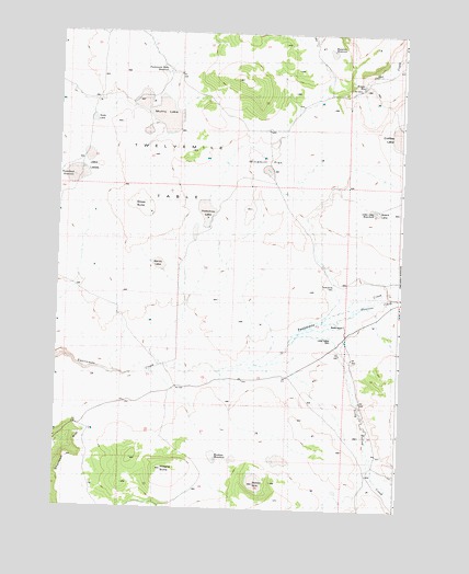
Hardin Ranch, OR USGS Topographic Map
Click on map above to begin viewing in our Map Viewer.

This topographic map contains these locations and features:
Feature Name Type Latitude Longitude GNIS ID View Map
Boston SinkFlatN43.8818°W119.9275°1157660View Map
Coffee LakeFlatN43.9735°W119.8764°1157666View Map
Eowyn ReservoirReservoirN43.9861°W119.8904°1157663View Map
Grass Butte ck rcd dataSummitN43.9547°W119.9672°1161188View Map
Hardin RanchLocaleN43.9240°W119.8958°1157667View Map
Jake LakesFlatN43.9650°W119.9908°1157653View Map
Little Lake WaterholeReservoirN43.9535°W119.8850°1157664View Map
Long Hollow CreekStreamN43.9215°W119.9066°1145415View Map
Long Hollow DamDamN43.9198°W119.9002°1157668View Map
Long Hollow ReservoirReservoirN43.9201°W119.9003°1157669View Map
Magpie ButteSummitN43.8854°W119.9608°1157658View Map
Muhly LakeFlatN43.9788°W119.9622°1161195View Map
Norcross CreekStreamN43.9315°W119.8758°1639329View Map
Old Lakebed WaterholeReservoirN43.9744°W119.8755°1166807View Map
Porkchop LakeFlatN43.9535°W119.9464°1157656View Map
Ryegrass ReservoirReservoirN43.9955°W119.9014°1157661View Map
Sandy LakeFlatN43.9390°W119.9636°1157657View Map
Sherman RimCliffN43.8893°W119.9908°1157178View Map
Soda LakeFlatN43.9768°W119.9886°1161196View Map
Speck LakeFlatN43.9535°W119.8844°1157665View Map
Thumbtack ReservoirReservoirN43.9621°W119.9897°1157654View Map
Twelvemile DamDamN43.9332°W119.9011°1131337View Map
Twelvemile ReservoirReservoirN43.9332°W119.9011°1131338View Map
Westlake WaterholeReservoirN43.8880°W119.9414°1157659View Map
Windmill FlatFlatN43.9665°W119.9239°1157655View Map

Note: Coordinates in the location and feature list above are referenced to NAD83 datum.


Copyright (C) 2008-2024 Ryan Niemi / Sunset Dynamics ... All Rights Reserved