TopoQuest Logo
Do you find TopoQuest useful?
Help keep TopoQuest running and adding new maps/features by donating!
Bitcoin:  19c7KJd3qBynnjoSw5npx9KScwjBe4ifkT
Litecoin:  LXs6TkuXGGXo1vDsWCkWVdjQX94eUKd6ui
Home View Maps Find Maps Find Places Resources & Links


Harmony, Minnesota Topographic Map

USGS Map Title: Harmony, MN
USGS Map MRC: 43092E1
DRG (GeoTIFF) Download: o43092e1.tif


Neighboring USGS Topographic Map Quads:


  Fountain, MN  
43092F2
 

  Preston, MN  
43092F1
 

  Lanesboro, MN  
43091F8
 

  Greenleafton, MN  
43092E2
 

  Harmony, MN  
43092E1
 

  Canton, MN  
43091E8
 

  Cresco NW, IA  
43092D2
 

  Cresco NE, IA  
43092D1
 

  Bluffton, IA  
43091D8


Map MRC Location:

N44°
W93°
N44°
W92°
H8 H7 H6 H5 H4 H3 H2 H1
G8 G7 G6 G5 G4 G3 G2 G1
F8 F7 F6 F5 F4 F3 F2 F1
E8 E7 E6 E5 E4 E3 E2 E1
D8 D7 D6 D5 D4 D3 D2 D1
C8 C7 C6 C5 C4 C3 C2 C1
B8 B7 B6 B5 B4 B3 B2 B1
A8 A7 A6 A5 A4 A3 A2 A1
N43°
W93°
N43°
W92°

Harmony, MN USGS 1:24K Topographic Map Preview:
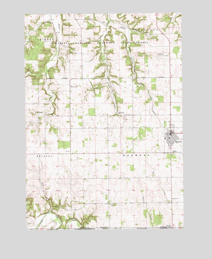
Harmony, MN USGS Topographic Map
Click on map above to begin viewing in our Map Viewer.

This topographic map contains these locations and features:
Feature Name Type Latitude Longitude GNIS ID View Map
Big SpringPopulated PlaceN43.5666°W92.0524°654604View Map
Big Spring CemeteryCemeteryN43.5661°W92.0404°640129View Map
Big Spring Post Office (historical)Post OfficeN43.5666°W92.0524°2050645View Map
City of HarmonyCivilN43.5540°W92.0075°2394299View Map
Daisy ValleyValleyN43.5100°W92.1063°642597View Map
East Side of TH 139 Wayside ParkParkN43.5175°W92.0093°2050854View Map
East Willow Creek DamDamN43.5533°W92.1085°1776459View Map
Fillmore Central High SchoolSchoolN43.5530°W92.0107°2050825View Map
Greenfield CemeteryCemeteryN43.5436°W92.0104°644436View Map
Greenfield Lutheran ChurchChurchN43.5522°W92.0107°2050827View Map
Gunderson Lutheran - Harmony ClinicHospitalN43.5469°W92.0104°2050835View Map
Hammervold Landing Field (historical)AirportN43.6002°W92.0140°2050832View Map
HarmonyPopulated PlaceN43.5552°W92.0102°644677View Map
Harmony (historical)LocaleN43.5569°W92.0118°2050814View Map
Harmony Fire DepartmentBuildingN43.5446°W92.0094°2666264View Map
Harmony Golf ClubLocaleN43.5583°W92.0065°2050824View Map
Harmony LibraryBuildingN43.5522°W92.0140°2050822View Map
Harmony Mobile Home ParkPopulated PlaceN43.5552°W92.0102°2050816View Map
Harmony Police DepartmentBuildingN43.5522°W92.0140°2050823View Map
Harmony Post OfficePost OfficeN43.5550°W92.0096°2050819View Map
Harmony Toy MuseumBuildingN43.5541°W92.0096°2050821View Map
Harmony United Methodist ChurchChurchN43.5536°W92.0093°2050828View Map
Harvest Farm CampgroundLocaleN43.5552°W92.0102°2050817View Map
HuttonPopulated PlaceN43.6161°W92.0449°654762View Map
Hutton CemeteryCemeteryN43.6158°W92.0396°645317View Map
Hutton Post Office (historical)Post OfficeN43.6161°W92.0449°2050619View Map
Miller Lange Pond DamDamN43.5500°W92.0335°1776452View Map
Nativity Catholic ChurchChurchN43.5502°W92.0110°2050826View Map
North ParkParkN43.5583°W92.0063°2050820View Map
Oak Hill CemeteryCemeteryN43.5038°W92.1238°648811View Map
Old Big Spring CemeteryCemeteryN43.5830°W92.0890°648918View Map
Partridge CreekStreamN43.6205°W92.0565°649171View Map
Rice CemeteryCemeteryN43.5452°W92.0896°649965View Map
Saint Paul's Lutheran ChurchChurchN43.5677°W92.0529°2050831View Map
Selvig ParkParkN43.5536°W92.0104°2050818View Map
State Line ChurchChurchN43.5008°W92.0107°652587View Map
State Line Methodist CemeteryCemeteryN43.5013°W92.0099°2050813View Map
Township of HarmonyCivilN43.5437°W92.0303°664399View Map
Vikre Manufactured Home ParkPopulated PlaceN43.5552°W92.0102°2050815View Map
Waukokee CemeteryCemeteryN43.6191°W92.1027°653856View Map

Note: Coordinates in the location and feature list above are referenced to NAD83 datum.


Copyright (C) 2008-2024 Ryan Niemi / Sunset Dynamics ... All Rights Reserved