TopoQuest Logo
Do you find TopoQuest useful?
Help keep TopoQuest running and adding new maps/features by donating!
Bitcoin:  19c7KJd3qBynnjoSw5npx9KScwjBe4ifkT
Litecoin:  LXs6TkuXGGXo1vDsWCkWVdjQX94eUKd6ui
Home View Maps Find Maps Find Places Resources & Links


Harris Lake, Colorado Topographic Map

USGS Map Title: Harris Lake, CO
USGS Map MRC: 37106B7
DRG (GeoTIFF) Download: o37106b7.tif


Neighboring USGS Topographic Map Quads:


  Jackson Mountain, CO  
37106C8
 

  Blackhead Peak, CO  
37106C7
 

  Summit Peak, CO  
37106C6
 

  Serviceberry Mountain, CO  
37106B8
 

  Harris Lake, CO  
37106B7
 

  Elephant Head Rock, CO  
37106B6
 

  Edith, CO  
37106A8
 

  Chromo, CO  
37106A7
 

  Chama Peak, CO  
37106A6


Map MRC Location:

N38°
W107°
N38°
W106°
H8 H7 H6 H5 H4 H3 H2 H1
G8 G7 G6 G5 G4 G3 G2 G1
F8 F7 F6 F5 F4 F3 F2 F1
E8 E7 E6 E5 E4 E3 E2 E1
D8 D7 D6 D5 D4 D3 D2 D1
C8 C7 C6 C5 C4 C3 C2 C1
B8 B7 B6 B5 B4 B3 B2 B1
A8 A7 A6 A5 A4 A3 A2 A1
N37°
W107°
N37°
W106°

Harris Lake, CO USGS 1:24K Topographic Map Preview:
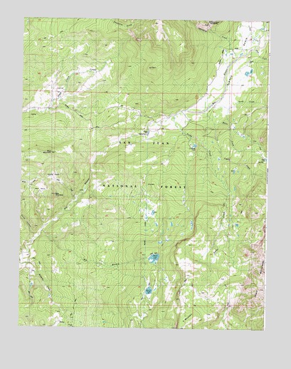
Harris Lake, CO USGS Topographic Map
Click on map above to begin viewing in our Map Viewer.

This topographic map contains these locations and features:
Feature Name Type Latitude Longitude GNIS ID View Map
Bear BasinBasinN37.1800°W106.8681°190996View Map
Bear MountainSummitN37.1789°W106.8575°190995View Map
Benson CreekStreamN37.1506°W106.8745°191015View Map
Big BranchStreamN37.1639°W106.8631°191008View Map
Blanco BasinBasinN37.2299°W106.7689°203513View Map
Blanco DamDamN37.2036°W106.8114°196980View Map
Blanco River TrailTrailN37.1847°W106.8648°191010View Map
Blanco TunnelTunnelN37.1361°W106.8114°1947479View Map
Blue MountainSummitN37.1958°W106.8600°190998View Map
Buckles LakeReservoirN37.1402°W106.8092°190985View Map
Castle CreekStreamN37.2078°W106.7775°191014View Map
Crescent LakeReservoirN37.1992°W106.7872°201489View Map
Fish CreekStreamN37.2381°W106.7567°190697View Map
Harris Brothers and Boone Number 1 DamDamN37.1417°W106.8089°200076View Map
Harris LakeReservoirN37.1536°W106.8067°191005View Map
Harris Lake DamDamN37.1533°W106.8095°200600View Map
Indian Trail CanyonValleyN37.1553°W106.8731°191007View Map
Leche CreekStreamN37.2106°W106.7995°191004View Map
Leche Creek TrailTrailN37.1253°W106.7700°169396View Map
Opal LakeLakeN37.1940°W106.7505°203514View Map
Slesinger DamDamN37.1983°W106.7873°201488View Map
South CreekStreamN37.2181°W106.7745°191031View Map
Sparks CanyonValleyN37.1619°W106.8674°191006View Map
Spring BasinBasinN37.1853°W106.8567°190999View Map
Squaretop Guard StationLocaleN37.2211°W106.8534°191000View Map
V MountainSummitN37.1297°W106.7873°191024View Map
V Rock TrailTrailN37.1917°W106.7561°203517View Map
V Rock TrailheadLocaleN37.1314°W106.8106°196979View Map
White CreekStreamN37.2128°W106.7842°191033View Map

Note: Coordinates in the location and feature list above are referenced to NAD83 datum.


Copyright (C) 2008-2024 Ryan Niemi / Sunset Dynamics ... All Rights Reserved