TopoQuest Logo
Do you find TopoQuest useful?
Help keep TopoQuest running and adding new maps/features by donating!
Bitcoin:  19c7KJd3qBynnjoSw5npx9KScwjBe4ifkT
Litecoin:  LXs6TkuXGGXo1vDsWCkWVdjQX94eUKd6ui
Home View Maps Find Maps Find Places Resources & Links


Hartsfield, Georgia Topographic Map

USGS Map Title: Hartsfield, GA
USGS Map MRC: 31083B8
DRG (GeoTIFF) Download: o31083b8.tif


Neighboring USGS Topographic Map Quads:


  Sale City, GA  
31084C1
 

  Doerun, GA  
31083C8
 

  Sigsbee, GA  
31083C7
 

  Cotton, GA  
31084B1
 

  Hartsfield, GA  
31083B8
 

  Moultrie, GA  
31083B7
 

  Meigs, GA  
31084A1
 

  Chastain, GA  
31083A8
 

  Coolidge, GA  
31083A7


Map MRC Location:

N32°
W84°
N32°
W83°
H8 H7 H6 H5 H4 H3 H2 H1
G8 G7 G6 G5 G4 G3 G2 G1
F8 F7 F6 F5 F4 F3 F2 F1
E8 E7 E6 E5 E4 E3 E2 E1
D8 D7 D6 D5 D4 D3 D2 D1
C8 C7 C6 C5 C4 C3 C2 C1
B8 B7 B6 B5 B4 B3 B2 B1
A8 A7 A6 A5 A4 A3 A2 A1
N31°
W84°
N31°
W83°

Hartsfield, GA USGS 1:24K Topographic Map Preview:
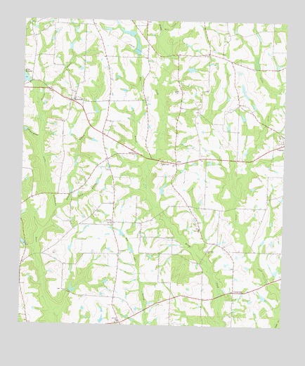
Hartsfield, GA USGS Topographic Map
Click on map above to begin viewing in our Map Viewer.

This topographic map contains these locations and features:
Feature Name Type Latitude Longitude GNIS ID View Map
BayPopulated PlaceN31.1919°W83.9266°331108View Map
Bay ChurchChurchN31.1927°W83.9327°343919View Map
Bethany ChurchChurchN31.1957°W83.9460°311130View Map
Big BranchStreamN31.1913°W83.9399°311304View Map
Bridge Creek CemeteryCemeteryN31.1919°W83.9346°343924View Map
Bridge Creek Primitive Baptist ChurchChurchN31.1919°W83.9335°354853View Map
Bridge Creek School (historical)SchoolN31.1388°W83.9024°343925View Map
Bridge Creek Structure Number 83 DamDamN31.2302°W83.9216°340848View Map
Bridge Creek Structure Number 83 LakeReservoirN31.2303°W83.9200°340849View Map
Brushy BranchStreamN31.2485°W83.9349°311918View Map
Center HillPopulated PlaceN31.1391°W83.8980°331366View Map
City of FunstonCivilN31.1989°W83.8770°2403672View Map
Collier School (historical)SchoolN31.1666°W83.9571°343935View Map
Colquitt County Volunteer Firefighters Association Fire Station 41 BayBuildingN31.1912°W83.9261°2604666View Map
Emory Carlton Airport (historical)AirportN31.2205°W83.9268°343956View Map
Funston DivisionCivilN31.1488°W83.9185°1936279View Map
Hamilton SchoolSchoolN31.1269°W83.9524°356151View Map
HartsfieldPopulated PlaceN31.2169°W83.9760°331923View Map
Hartsfield Post OfficePost OfficeN31.2169°W83.9769°352175View Map
McNeil School (historical)SchoolN31.1299°W83.9732°343984View Map
Mill CreekStreamN31.2463°W83.9346°318214View Map
Moss LakeReservoirN31.2393°W83.9459°341755View Map
Moss Lake DamDamN31.2352°W83.9449°341754View Map
Moss Lake Dam NorthDamN31.2435°W83.9482°341756View Map
Moss Lake NorthReservoirN31.2452°W83.9502°341757View Map
Oak Grove ChurchChurchN31.1560°W83.9105°319763View Map
Piney BranchStreamN31.1760°W83.9774°320692View Map
Rose Hill Baptist Church CemeteryCemeteryN31.1668°W83.9578°2767394View Map
Rose Hill ChurchChurchN31.1669°W83.9568°321918View Map
Sinners Friend ChurchChurchN31.2082°W83.9802°323037View Map
Slocumb BranchStreamN31.2157°W83.9924°323085View Map
Thigpen BranchStreamN31.2007°W83.9918°324065View Map
Watery BranchStreamN31.1721°W83.9832°324911View Map
Zion Hill ChurchChurchN31.1646°W83.9146°325688View Map

Note: Coordinates in the location and feature list above are referenced to NAD83 datum.


Copyright (C) 2008-2025 Ryan Niemi / Sunset Dynamics ... All Rights Reserved