TopoQuest Logo
Do you find TopoQuest useful?
Help keep TopoQuest running and adding new maps/features by donating!
Bitcoin:  19c7KJd3qBynnjoSw5npx9KScwjBe4ifkT
Litecoin:  LXs6TkuXGGXo1vDsWCkWVdjQX94eUKd6ui
Home View Maps Find Maps Find Places Resources & Links


Harvard, Nebraska Topographic Map

USGS Map Title: Harvard, NE
USGS Map MRC: 40098E1
DRG (GeoTIFF) Download: o40098e1.tif


Neighboring USGS Topographic Map Quads:


  Harvard NW, NE  
40098F2
 

  Harvard NE, NE  
40098F1
 

  Stockham, NE  
40097F8
 

  Inland, NE  
40098E2
 

  Harvard, NE  
40098E1
 

  Saronville, NE  
40097E8
 

  Fairfield NW, NE  
40098D2
 

  Fairfield, NE  
40098D1
 

  Edgar NW, NE  
40097D8


Map MRC Location:

N41°
W99°
N41°
W98°
H8 H7 H6 H5 H4 H3 H2 H1
G8 G7 G6 G5 G4 G3 G2 G1
F8 F7 F6 F5 F4 F3 F2 F1
E8 E7 E6 E5 E4 E3 E2 E1
D8 D7 D6 D5 D4 D3 D2 D1
C8 C7 C6 C5 C4 C3 C2 C1
B8 B7 B6 B5 B4 B3 B2 B1
A8 A7 A6 A5 A4 A3 A2 A1
N40°
W99°
N40°
W98°

Harvard, NE USGS 1:24K Topographic Map Preview:
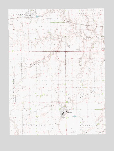
Harvard, NE USGS Topographic Map
Click on map above to begin viewing in our Map Viewer.

This topographic map contains these locations and features:
Feature Name Type Latitude Longitude GNIS ID View Map
Aurora Cooperative Elevator Company ElevatorLocaleN40.5203°W98.0587°1882432View Map
Aurora Cooperative Elevator Company ElevatorLocaleN40.6189°W98.0973°1882334View Map
City of Clay CenterCivilN40.5255°W98.0550°837923View Map
City of HarvardCivilN40.6201°W98.0961°2394316View Map
Clay CenterPopulated PlaceN40.5217°W98.0553°828169View Map
Clay Center (historical)LocaleN40.5217°W98.0592°1882434View Map
Clay Center CemeteryCemeteryN40.5325°W98.0503°828170View Map
Clay Center Community Medical ClinicHospitalN40.5217°W98.0553°1882426View Map
Clay Center Dental ClinicHospitalN40.5217°W98.0553°1882427View Map
Clay Center Historical MarkerParkN40.5247°W98.0559°1882438View Map
Clay Center Police DepartmentBuildingN40.5216°W98.0569°2739901View Map
Clay Center Police DepartmentBuildingN40.5217°W98.0556°1882428View Map
Clay Center Post OfficePost OfficeN40.5210°W98.0560°1882430View Map
Clay Center Public LibraryBuildingN40.5217°W98.0556°1882431View Map
Clay Center Public SchoolsSchoolN40.5236°W98.0509°1882440View Map
Clay Center Volunteer AmbulanceBuildingN40.5205°W98.0556°2553733View Map
Clay Center Volunteer Fire DepartmentBuildingN40.5216°W98.0569°2553251View Map
Clay CountyCivilN40.5244°W98.0513°835839View Map
Clay County CourthouseBuildingN40.5214°W98.0550°1882436View Map
Clay County FairgroundLocaleN40.5292°W98.0587°1882439View Map
Clay County Sheriff's OfficeBuildingN40.5212°W98.0550°1882437View Map
Crooked Creek Country ClubLocaleN40.5267°W98.0553°1882435View Map
HarvardPopulated PlaceN40.6189°W98.0973°829840View Map
HarvardLocaleN40.6167°W98.0976°1882336View Map
Harvard City ParkParkN40.6242°W98.0953°1882397View Map
Harvard Historical MarkerParkN40.6242°W98.0953°1882398View Map
Harvard Police DepartmentBuildingN40.6192°W98.0972°1882339View Map
Harvard Post OfficePost OfficeN40.6195°W98.0975°1882338View Map
Harvard Public LibraryBuildingN40.6192°W98.0976°1882340View Map
Harvard Public SchoolsSchoolN40.6222°W98.0906°1882344View Map
Harvard Rest HavenHospitalN40.6231°W98.0926°1882335View Map
Harvard Volunteer Fire and RescueBuildingN40.6176°W98.0983°1882337View Map
Hultine DamDamN40.5733°W98.0003°1766947View Map
Hultine ReservoirReservoirN40.5726°W98.0022°1766948View Map
Saint Joseph Catholic ChurchChurchN40.6225°W98.0948°1882343View Map
Township of LynnCivilN40.5685°W98.1090°838120View Map
United Church of ChristChurchN40.5200°W98.0562°1882433View Map
United Church of ChristChurchN40.6150°W98.0959°1882341View Map
United Methodist ChurchChurchN40.6211°W98.0989°1882342View Map
Zion Lutheran ChurchChurchN40.5217°W98.0564°1882429View Map

Note: Coordinates in the location and feature list above are referenced to NAD83 datum.


Copyright (C) 2008-2025 Ryan Niemi / Sunset Dynamics ... All Rights Reserved