TopoQuest Logo
Do you find TopoQuest useful?
Help keep TopoQuest running and adding new maps/features by donating!
Bitcoin:  19c7KJd3qBynnjoSw5npx9KScwjBe4ifkT
Litecoin:  LXs6TkuXGGXo1vDsWCkWVdjQX94eUKd6ui
Home View Maps Find Maps Find Places Resources & Links


Harvey Mountain, California Topographic Map

USGS Map Title: Harvey Mountain, CA
USGS Map MRC: 40121F1
DRG (GeoTIFF) Download: o40121f1.tif


Neighboring USGS Topographic Map Quads:


  Corders Reservoir, CA  
40121G2
 

  Straylor Lake, CA  
40121G1
 

  Bullard Lake, CA  
40120G8
 

  Poison Lake, CA  
40121F2
 

  Harvey Mountain, CA  
40121F1
 

  Champs Flat, CA  
40120F8
 

  Bogard Buttes, CA  
40121E2
 

  Pine Creek Valley, CA  
40121E1
 

  Antelope Mountain, CA  
40120E8


Map MRC Location:

N41°
W122°
N41°
W121°
H8 H7 H6 H5 H4 H3 H2 H1
G8 G7 G6 G5 G4 G3 G2 G1
F8 F7 F6 F5 F4 F3 F2 F1
E8 E7 E6 E5 E4 E3 E2 E1
D8 D7 D6 D5 D4 D3 D2 D1
C8 C7 C6 C5 C4 C3 C2 C1
B8 B7 B6 B5 B4 B3 B2 B1
A8 A7 A6 A5 A4 A3 A2 A1
N40°
W122°
N40°
W121°

Harvey Mountain, CA USGS 1:24K Topographic Map Preview:
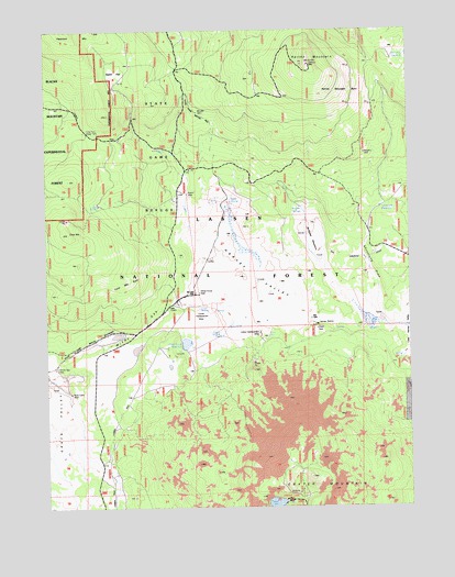
Harvey Mountain, CA USGS Topographic Map
Click on map above to begin viewing in our Map Viewer.

This topographic map contains these locations and features:
Feature Name Type Latitude Longitude GNIS ID View Map
Aspen FlatFlatN40.7377°W121.1027°256354View Map
Aspen WellWellN40.7066°W121.0794°256358View Map
Barrell Pit ReservoirReservoirN40.7416°W121.0102°256552View Map
Burgess CabinLocaleN40.7182°W121.0175°257704View Map
Burgess MeadowFlatN40.6946°W121.0327°257706View Map
Burgess SpringsSpringN40.7024°W121.0377°257707View Map
Burgess WellWellN40.7174°W121.0164°1665840View Map
Cone MountainSummitN40.6968°W121.1180°258636View Map
Cone Mountain BurnAreaN40.6871°W121.0991°221444View Map
Cone SpringSpringN40.6776°W121.0730°1665850View Map
Cone Two Water TankReservoirN40.7229°W121.1116°1665851View Map
Cones HeadquartersLocaleN40.6763°W121.0741°258639View Map
Crater LakeLakeN40.6259°W121.0477°258888View Map
Crater Lake CampgroundLocaleN40.6268°W121.0427°275043View Map
Dixie SpringSpringN40.7049°W121.0650°259406View Map
Harvey MountainSummitN40.7410°W121.0361°261131View Map
Harvey Mountain BurnAreaN40.7341°W121.0261°1665865View Map
Harvey Mountain LookoutLocaleN40.7407°W121.0350°275042View Map
Harvey ValleyValleyN40.6724°W121.0214°261132View Map
Lost SpringSpringN40.7032°W121.1108°262964View Map
Lyons HeadquartersLocaleN40.6704°W121.0536°263087View Map
Lyons SpringSpringN40.6698°W121.0662°1665887View Map
Lyons WellWellN40.6702°W121.0497°1802902View Map
Rock Cabin WellWellN40.6546°W121.1205°265471View Map
Shoestring DrawValleyN40.6743°W121.0100°266129View Map
Shoestring ReservoirReservoirN40.7037°W121.0107°1665903View Map
White Horse ReservoirReservoirN40.6681°W121.0765°269005View Map
White Horse WellWellN40.6810°W121.0397°1802903View Map
Windy GapGapN40.6710°W121.0925°1665927View Map
Windy Gap WellWellN40.6607°W121.1250°269231View Map

Note: Coordinates in the location and feature list above are referenced to NAD83 datum.


Copyright (C) 2008-2025 Ryan Niemi / Sunset Dynamics ... All Rights Reserved