TopoQuest Logo
Do you find TopoQuest useful?
Help keep TopoQuest running and adding new maps/features by donating!
Bitcoin:  19c7KJd3qBynnjoSw5npx9KScwjBe4ifkT
Litecoin:  LXs6TkuXGGXo1vDsWCkWVdjQX94eUKd6ui
Home View Maps Find Maps Find Places Resources & Links


Haskell, Oklahoma Topographic Map

USGS Map Title: Haskell, OK
USGS Map MRC: 35095G6
DRG (GeoTIFF) Download: o35095g6.tif


Neighboring USGS Topographic Map Quads:


  Leonard, OK  
35095H7
 

  Coweta, OK  
35095H6
 

  Red Bird, OK  
35095H5
 

  Concharty Mountain, OK  
35095G7
 

  Haskell, OK  
35095G6
 

  Taft, OK  
35095G5
 

  Okmulgee NE, OK  
35095F7
 

  Boynton, OK  
35095F6
 

  Beland, OK  
35095F5


Map MRC Location:

N36°
W96°
N36°
W95°
H8 H7 H6 H5 H4 H3 H2 H1
G8 G7 G6 G5 G4 G3 G2 G1
F8 F7 F6 F5 F4 F3 F2 F1
E8 E7 E6 E5 E4 E3 E2 E1
D8 D7 D6 D5 D4 D3 D2 D1
C8 C7 C6 C5 C4 C3 C2 C1
B8 B7 B6 B5 B4 B3 B2 B1
A8 A7 A6 A5 A4 A3 A2 A1
N35°
W96°
N35°
W95°

Haskell, OK USGS 1:24K Topographic Map Preview:
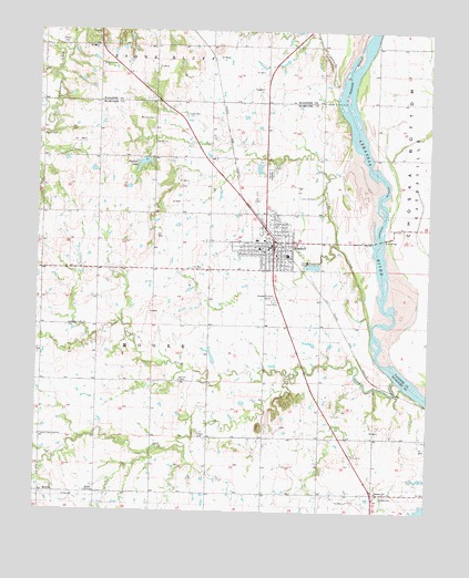
Haskell, OK USGS Topographic Map
Click on map above to begin viewing in our Map Viewer.

This topographic map contains these locations and features:
Feature Name Type Latitude Longitude GNIS ID View Map
Ash CreekStreamN35.7848°W95.6355°1089726View Map
Cane Creek Site 1 DamDamN35.7518°W95.6253°1757251View Map
Cane Creek Site 1 ReservoirReservoirN35.7505°W95.6262°1757252View Map
Church of the Living GodChurchN35.7695°W95.7489°1091362View Map
Coal CreekStreamN35.7979°W95.6433°1091497View Map
Coburn LakeReservoirN35.7501°W95.6253°1755331View Map
Coburn Lake DamDamN35.7501°W95.6253°1755330View Map
Concharty CreekStreamN35.8582°W95.6544°1091601View Map
Creek ChurchChurchN35.7654°W95.6486°1091812View Map
Friday CemeteryCemeteryN35.7701°W95.6983°1093050View Map
Gary BridgeBridgeN35.8212°W95.6405°1093144View Map
Gibson CemeteryCemeteryN35.8712°W95.7422°1093182View Map
HaskellPopulated PlaceN35.8204°W95.6741°1093591View Map
Haskell AirportAirportN35.8302°W95.6684°1102496View Map
Haskell CemeteryCemeteryN35.8381°W95.6755°1093592View Map
Haskell DivisionCivilN35.7869°W95.6949°1937724View Map
Haskell High SchoolSchoolN35.8261°W95.6847°1790358View Map
Haskell LakeReservoirN35.8407°W95.7166°1093594View Map
Haskell Lake DamDamN35.8418°W95.7153°1755340View Map
Haskell Middle SchoolSchoolN35.8258°W95.6851°1790359View Map
Haskell Police DepartmentBuildingN35.8185°W95.6753°2757614View Map
Haskell Post OfficePost OfficeN35.8149°W95.6754°1814370View Map
Haskell Volunteer Fire DepartmentBuildingN35.8184°W95.6740°2656889View Map
JamesvillePopulated PlaceN35.7551°W95.6405°1100534View Map
Mary White Elementary SchoolSchoolN35.8208°W95.6804°1790673View Map
MidwayPopulated PlaceN35.7548°W95.7486°1100635View Map
Midway ChurchChurchN35.7551°W95.7322°1095379View Map
Mount Zion CemeteryCemeteryN35.8523°W95.7130°1095620View Map
Mount Zion ChurchChurchN35.8459°W95.7119°1095631View Map
Oknoname 101004 DamDamN35.8401°W95.6803°1755352View Map
Oknoname 101004 ReservoirReservoirN35.8395°W95.6799°1755353View Map
Oknoname 101009 DamDamN35.7884°W95.6936°1755360View Map
Oknoname 101009 ReservoirReservoirN35.7901°W95.6941°1755361View Map
Phyllis CemeteryCemeteryN35.8476°W95.7489°1096610View Map
Pleasant Valley ChurchChurchN35.7984°W95.7394°1096765View Map
Salt CreekStreamN35.7851°W95.6686°1097687View Map
Simmons ChapelChurchN35.7843°W95.7042°1098055View Map
Town of HaskellCivilN35.8187°W95.6805°2412732View Map
Township of MooreCivilN35.7918°W95.7086°1824620View Map

Note: Coordinates in the location and feature list above are referenced to NAD83 datum.


Copyright (C) 2008-2024 Ryan Niemi / Sunset Dynamics ... All Rights Reserved